

Thinksnow18
-
Posts
4,144 -
Joined
-
Last visited
Content Type
Profiles
Blogs
Forums
American Weather
Media Demo
Store
Gallery
Posts posted by Thinksnow18
-
-
3 minutes ago, BuffaloWeather said:
Forecast for airport
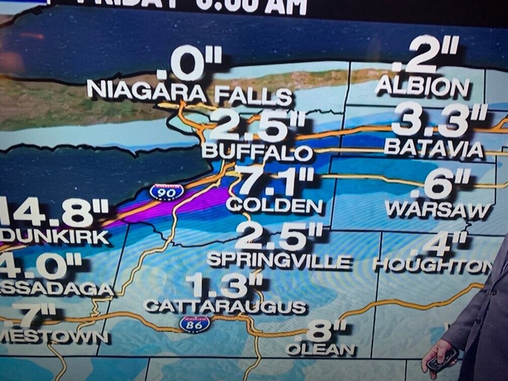
TonightSnow showers likely before 10pm, then snow after 10pm. The snow could be heavy at times. Areas of blowing snow after 9pm. Low around 24. Breezy, with a southwest wind 22 to 25 mph, with gusts as high as 37 mph. Chance of precipitation is 100%. New snow accumulation of 5 to 9 inches possible.ThursdaySnow. The snow could be heavy at times. High near 27. Southwest wind 11 to 18 mph, with gusts as high as 33 mph. Chance of precipitation is 100%. New snow accumulation of 3 to 7 inches possible.Thursday NightSnow, mainly before 4am, then a chance of snow showers after 4am. Low around 20. Southwest wind 5 to 8 mph becoming calm after midnight. Chance of precipitation is 80%. New snow accumulation of 2 to 4 inches possibleSo 10-20” range.
-
15 minutes ago, lakeeffectkid383 said:
Channel 4 newest model run brings the bullseye even further south. Gonna be a true nowcasting event.
Mike Is on an island by himself
-
12 minutes ago, BuffaloWeather said:
Feeling really optimistic after looking at Michigan, we will have a stronger band then they do and thats 1"+ per hour already.
And look at that trajectory!
-
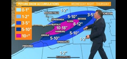
While I NEVER feel comfortable about LES, seeing all 6 models pretty much lockstep right now does make me a bit more optimistic. And looking at the snowfall forecast map from the NWS the biggest difference is the stripes of snow north of Buffalo have widened by a few miles. The 8-12” now solidly gets near the 990 and the 4-8 gets all the way to Tonawanda by the 290. This is different from yesterday when those areas were more in the 2-4 category, and the 8-12” area was a cutoff right near my location.
-
 1
1
-
-
9 minutes ago, SouthBuffaloSteve said:
12z runs locked into a very nice agreement! The original call from KBUF still looking spot on. Might not be our double whoppers with cheese meal but I'm still down! Let's get this show on the road!

Most of those included all of metro Buffalo north-side and south side. Looks good ATM
-
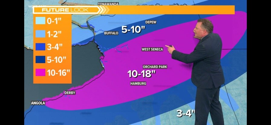
1 minute ago, Buffalo Bumble said:
My call, from north to south:
* My house (Snyder, just west of Williamsville): <1"
* BUF Airport: 4"
* Lancaster/Depew: 12"
* Ebenezer (West Seneca): 18"
* Orchard Park: 8"
* Hamburg: 6"
Too low for the airport. Foot at KBUF 8” in Williamsville 3-6 for west Amherst/Snyder and I sgeee with the rest
-
1 minute ago, TugHillMatt said:
That was a classic show.
-
1
-
 1
1
-
-
4 minutes ago, SouthBuffaloSteve said:
Almost forgot the RGEM at 6! Looks so much better! Knew something was off with yesterday’s run. This gives a huge confidence boost to the NWS forecast with a park job right over the metro!

That map makes perfect sense of a 240-250 flow
-
1 minute ago, SouthBuffaloSteve said:
HRRR with a big paint brush tip this morning.

My guess is that’s the model Mike is using. That’s an almost carbon copy if his map.
-
6 minutes ago, lakeeffectkid383 said:
Idk what to think. It’s gotta be super tough to forecast right now. Models have shifted south but history tells us these things come north 5 miles so not sure. I think Mike’s map looks alright, maybe just shift everything north 5 miles.
That’s my thought because he has warning snowfall in Chautauqua county. His heaviest is Boston hills. I made fun of him last year for this and out of the three Mets yesterday (Don, Todd and himself) he was the only one this south. Don even stated that he and Todd discussed this and after reading BW and his conversation with Tom Niziol I feel all three of them collaborated.
-
4 minutes ago, lakeeffectkid383 said:
And did you notice what Aaron did? Even though the color shades show a further south solution, he shifted his totals north of the coloring…he’s not just blindly following bad guidance.
-
1
-
-
3 minutes ago, lakeeffectkid383 said:
Yep I agree with these two…mike was out on a raft in the pacific…
-
Expecting between 6-10” is my guess as I’m probably just a mile or two north of the heaviest snows for this one. West Seneca, Cheektowaga, Lancaster, South Buffalo and Depew Jackpot this one IMO.
-
29 minutes ago, Buckeyes_Suck said:
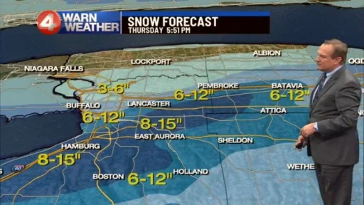
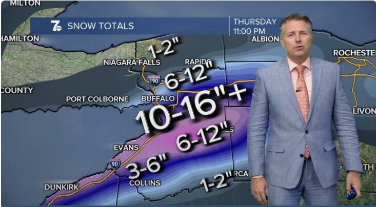
Warnings issued for 8-15, I’ll take that.

I just watched WIVB…Mike Cejka is about 25 miles south of the NWS with his Placement of the band and snow accumulation.
-
 1
1
-
-
Just now, BuffaloWeather said:
Yeah looks good 10-15" with 1-2 spots getting 20". I don't know why everyone is down on this event, its a pretty good one. Some years like two years ago we go the entire year with one good band.
I’m not down on it! It’s a share the wealth type of event. I’d take 8-9” over nothing any day.
-
3
-
-
13 minutes ago, SouthBuffaloSteve said:
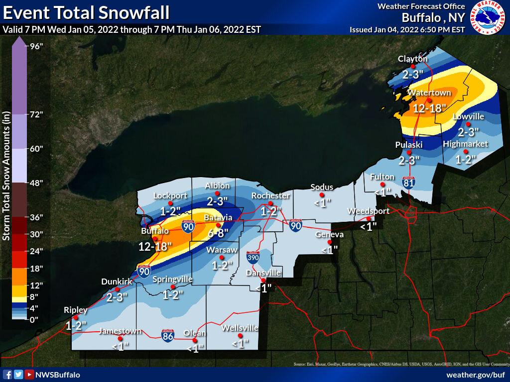
Pick your poison I guess? Of course the RGEM had to flip a little more north...One half of Erie County is getting 4-8" and the other half 10-16". NWS map looks fine! Might have to spread the bullseye a few miles south but not much. Pop the warnings for N Erie S Erie Genesee advisory for touching squares and let it rip!

Bottom 3 are very similar in location and amounts. That seems the logical outcome. HRRR is still drunk from the holidays…
-
1
-
-
4 minutes ago, BuffaloWeather said:
The NAM has a more WSW flow for entire duration of event. A brutal forecast with that low passing to SE and the shortwave to the NW. One of the more difficult LES forecast in awhile. Can understand why KBUF is holding off so long. The event starts tomorrow afternoon, less than 18 hours away.
I thought Tom Niziol was using the NAM? In his estimation it kinda gets everyone from the Niagara/Erie Co border to Hamburg?
-
My question is all the verbiage states warning criteria snows in all 4 zones in the WSW…so why not raise it to a warning and smooth out details as it takes shape in later runs?
-
46 minutes ago, lakeeffectkid383 said:
I look at all the models. Best model for lake effect IMO is the RGEM, and when other guidance starts showing similar output regardless of the model it gives it more credence. Anything can happen but there’s no reason to ignore the trends which unfortunately for us don’t seem to be going in the right direction for a huge event.
Huge event? No. A foot? I’m not going to throw that away
-
1
-
-
3 minutes ago, lakeeffectkid383 said:
Updated map. Keeps on shrinking.
now in the 8-12” zone here, barely.

The bullseye is shrinking but the area actually widened
-
59 minutes ago, SouthBuffaloSteve said:
Yeah that system is making me a bit nervous now. GFS says don’t worry but RGEM and ICON say panic.
Few good blurbs from DP…
When have you EVER looked to the ICON fir Lake Effect?!?!?!
-
1 minute ago, lakeeffectkid383 said:
Yeah no way. Maybe they wait until after tonight’s 00z runs to pull the trigger on warnings. I mean sure somewhere in Erie County is gonna get warning amounts so issuing a warning is almost a sure thing but where would you put the bullseye right now if you had to make a call. I agree with your map earlier and think the bullseye will be around WS somewhere but man I could see it being Amherst/Williamsville or Hamburg/OP.
Don just said he thinks they’ll call it in the next half hour.
-
DP is on WIVB…the right met to have in right now
-
1
-
-
25 minutes ago, SouthBuffaloSteve said:
https://www.weather.gov/buf/lesEventArchive?season=2010-2011&event=B

Then a lake plume developed by
early afternoon on a 260 flow and intensified by 3 pm or so as it
rolled into the Buffalo Southtowns.
The band then lifted north a bit on a 255 flow during the early
evening and remained pretty much locked in place for the next 30
hours or so.  None of the parameters for lake effect were
outstanding...but they were all quite favorable for a near perfect
early season lake effect plume off Erie...850 mb temps of -11c...a
fairly high equilibrium level/inversion (l0k ft.)...very good
moisture fields below the inversion, good snow growth, no shear and
moderate winds. There was the typical thunder and lightning we see
during early season events but nothing extreme. The wind fields
finally weakened with increasing shear as a surface ridge built in
by Friday morning (3rd)...disrupting and dissipating the band.
Snowfall amounts were incredible within the band. A general 30 to 40
inches fell in about a five mile strip which ran from Lackawanna and
southeast Buffalo...east northeast across northern West Seneca,
south Cheektowaga, Depew and Lancaster over to Alden. Amounts
dropped off steadily to the south...with about a foot in Orchard
Park and less further south. The real story was the northern
gradient though. Amounts dropped from two feet to a dusting in just
a 3 or 4 mile distance! This was evident along north-south roads
like Transit and Harlem. For example, no measurable snow fell at
Main and Harlem, but two feet at Walden and Harlem. The Buffalo
Airport was right at the cutoff...with 2 inches at its northwest
comer and a foot at its southeast comer! Further west...no snow fell
in Buffalo at North St., 4 inches at City Hall and a foot at HSBC
arena...probably the most remarkable gradient ever seen across the
city!
This event had major impact...not only in the 300,000 or so people
affected ...but from a major backup and shut down of the NYS Thruway
from Exit 52 to 54...with hundreds stranded for almost 24 hours.
Activity off Lake Ontario...usually fairly similar to Erie...did not
materialize nearly as well this time. There was a broad area of snow
showers and heavier snow...but single banding never did develop.
Shear was much greater and temperatures a bit milder and marginal.
A general 5 to 8 inches fell across areas where the snow persisted
longest...one just north of Watertown over to Harrisville ...
I also just learned that 240 is more north Buffalo as 250 is Cheektowaga airport…that means the area from roughly the 990 south to Hamburg or just north slightly is fair game in a 240-250 vector


Upstate/Eastern New York- Jan 5-7 Lake Effect Snow Event
in Upstate New York/Pennsylvania
Posted
7-16” for Williamsville