

North and West
-
Posts
2,519 -
Joined
-
Last visited
Content Type
Profiles
Blogs
Forums
American Weather
Media Demo
Store
Gallery
Posts posted by North and West
-
-
I miss those days. Still watch the 96 blizzard coverage for nostalgia.
I do that with January and February 1994 to make me feel like I’m in sixth grade again.
.-
 2
2
-
-
-
If there was blocking would this be a much bigger storm right
That’s assuming all other data points were identical, which we would have no way of knowing.
.-
1
-
-
996mb just a tad bit south of the benchmark....

Clears up that double barrel b.s. look in the previous tracking guidance
Enjoy your snow!!!!

https://ocean.weather.gov/Atl_tab.php
.-
1
-
 1
1
-
-
This has the post-Super Bowl 2014, December 5, 2002, February 7, 2003, feel to it. A nice, normal snowstorm.
.-
4
-
-
Hopefully this one is a little colder than Super Bowl last year and it’s overnight so there’s no issue with the snow sticking. I remember in Long Beach for that one the beginning was rain and we wasted a good amount on non accumulating snow. Up where I am now it was considerably better.
I was just thinking that (MMU scored well on there) or the December 5, 2002 event.
. -
I expect this will come back to the bench mark. Nothing wrong with a 3-6/4-8 storm. Especially when we got nothing so far

.-
1
-
-
The emotion displayed over getting or not getting a few flakes is interesting. Sorta. Not really...
.-
1
-
 1
1
-
-
If that happens, so be it. I have no control over the weather. Not sure how he's so confident about the MJO though. When NOAA is even unsure and there is no clarity in modeling yet. Maybe he's right. Maybe he isn't. We're still waiting for that epic pattern composite he made to show up.
He’s got a 50/50 chance, and I’ve become more convinced in my elder age that seasonal forecasting is that.
.-
2
-
-
NWS Eastern Region.

STOP THE COUNT
.-
1
-
 1
1
-
4
-
-
Wasn’t there a winter in the 2010s that was just as good or close to it?
Maybe? 2014 was nice for that, and we had some good storms during the decade, but 1994 stuck out for the main reason that it was record cold, countless ice and snow events, and then some big snow in February.
This happened after years of nothing… it’s extra special like when your team wins for the first time in years.
It also helped that I was 11 and grew up BEGGING for it to snow throughout elementary school and it seemingly never, ever did, and I had to sit and watch the weather channel and marni stanier’s ceiling fan infomercial while waiting on the five day business planner :50 after the hour.
.-
2
-
-
I started my weenie career on Bill Evans forum.
Oh man! I remember Bill himself going on his forum prior to the February 2003 storm to let us know it was going to be a doozy.
These forums would have been BONKERS if they had existing in 1994. Still my favorite winter of all time.
.-
2
-
-
well central park had no snow and even without snow with this air mass would have been in the single digits 25 years ago..

That’s a 10°+ temperature swing. How do you figure?
. -
yup 2-4 inches of snow that doesn't mix or changeover is highly underrated.
Agreed! I like those moderate all-snow storms that are in the 6-12 range… pretties things up, it’s cold so it’s powder, easy to clean, no ice, but doesn’t break your back clearing it off.
.-
1
-
-
Either way we're going to get some snow out of it.
A lot better than what happened yesterday, right?
.-
2
-
-
Nah, I've been scanning weather forums for decades. This is odd.
I think it’s just exhaustion from COVID, missing out on today’s snow, and getting back into normal work/school/family life on the first day after a long break.
.-
2
-
-
last february says hi. enso climo doesn't mean anything anymore
You obviously know a lot more than I do, but the long ranges fluctuate so much, who the hell knows in the end.
. -
Like a Virga… dry air filtering in for the umpteenth time
.-
2
-
-
A significant snowfall in DC, it's about damn time. If I manage to get a snow shower out of this I'll be happy.
Good for them. Let them enjoy it. We’ll get ours, whether it’s this year or next. We’ve been very spoiled.
Kind of reminds me of having your plate overflowing and you’re annoyed someone else is going up to the buffet. (Pre-Covid, of course)
.-
1
-
-
This is a miss for NYC metro…
c’est la vie say the old folks
.-
2
-
-

.-
2
-
1
-
-
Can you post the snow map?

.-
1
-
-
My hopes are for a coating to a inch here locally. Would be nice to get with the artic airmass coming in. DCA towards acy is going to get crushed! Good for them
Right? Of course I like a good storm, but I can’t have one all of the time. Let someone else enjoy it. I’m sure there are people down the shore that have missed out recently. I’ve had a ton of really good ones for years.
The last big miss was February 2010? So what. That’s 12 years now. Not a bad track record.
.-
1
-
-
You know what to expect
You just dont like it though

.-
1
-
1
-
1
-


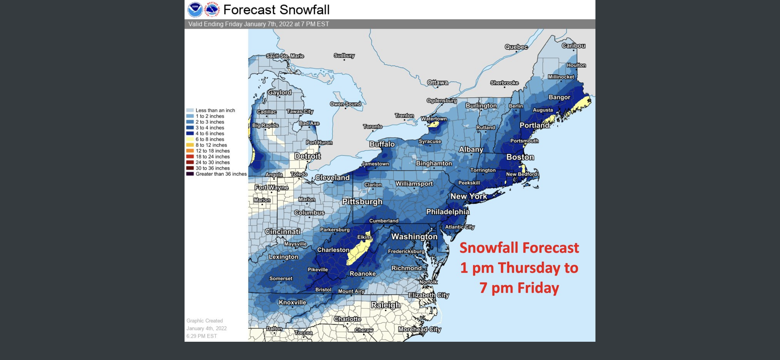
Small or possibly moderate wintry event possible for a portion of the NYC subforum Friday morning-early afternoon 1/7/22
in New York City Metro
Posted
+1 for the Meta mid-‘90s reference
.