

Hotair
-
Posts
548 -
Joined
-
Last visited
Content Type
Profiles
Blogs
Forums
American Weather
Media Demo
Store
Gallery
Everything posted by Hotair
-
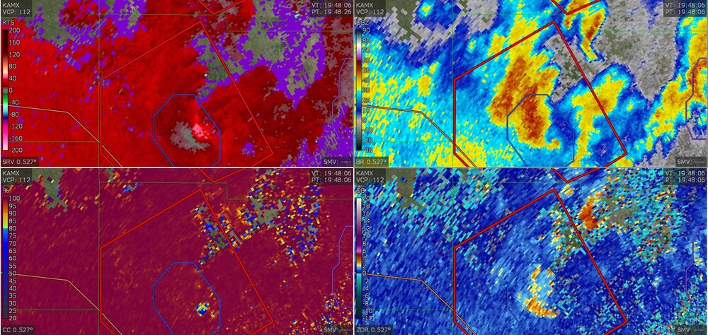
First reports of tornadoes spawning in Florida from Ian Giovanni Rizzotti (2-1) (80-73) (0-0) @Gio_wx · 5s Debris ball over the Everglades in Miami-Dade County, Florida. Likely a significant tornado over a highly rural area.
-
-
Treyce Jones @FLweather_wx said In 30-36 hours, 12z HWRF & HMON both show Ian as a high end Cat 4 just off the FL coast. This is looking increasingly concerning. The impacts are likely going to be devastating. Be safe everyone! worrisome that recon is indeed also showing the type of intensification that could easily take Ian into high end C4 territory.
-
Are any of the models running now accounting for the latest intensity recon is finding at this hour? Ian looks stronger now than NHC had forecast at 11 am. Those of you who study gulf canes, is it a sound assumption that higher intensity will resist eastward steering more resulting in a more Northward track for longer vs a weaker storm?
-
No significant impacts from land interaction are evident in the latest recon and radar presentation. Assuming it continues to travel along bathtub temperature waters, it’s becoming more and more likely that C4 can be achieved later today
-
Video is starting to trickle in from some of the affected areas in Pinar del Rio. Widespread damage seen. Many roofs blown off. Disastrous for that region
-
Try as I can I still don’t see a NÉ component to motion on radar. Sort of straight North. Is there a loop that shows this better? I’m going by keys radar
-
I traveled to Lakeland to stay with our son. Looks like euro says I’m gonna have front row seats. Without storm surge of course, New evacs now issued for western Lee County (including Sanibel & Captiva). impacts could be MUCH bigger Venice, Punta Gorda, Fort Myers than had previously been anticipated. impacts begin tomorrow, worst tomorrow afternoon through Thursday morning.
-
I’ll take a Sarasota landing from these latest runs at this point. Especially if it comes in along near empty corridors and stays inland I mean it’s going to be a terrible storm any way you slice it. Might as well spare High cat 3 winds into Tampa Bay which has the highest population center of the entire west coast region.
-
Isla de La Juventud and Pinar del Rio are about to get a whopping when Ian makes landfall with close to Cat 3 strength. Electric utilities in that part of the island are as poor if not worse than what Puerto Rico has. Last cane in those areas power was not restored for several weeks.
-
Indeed. I mean total property damage would probably be much lower if it comes in hot well South of TB and goes inland than if it stays parallel to TB and churns water into the bay for hours. but my guess is that people South of Ft Meyers have not been too keen on preparations for a Major LF event
-
The 18z euro just reminded me of Charley in 2004
-
Recon finding 107 mph winds. This might get to Cat 3 by the 11 pm advisory and prior to landfall at Pinar Del Rio Cuba
-
Update: Tampa Bay International Airport to suspend operations at 5 p.m. on Tuesday ahead of Hurricane Ian per governor
-
Tampa intl airport says may begin to shut down operations in next 24 hours Update: Tampa Bay International Airport to suspend operations at 5 p.m. on Tuesday ahead of Hurricane Ian per governor
-
Geez. I can see from my outdoor cameras in my home in Tampa that it is raining hard right now ground is going to be soaked by the time Ian rains arrive
-
-
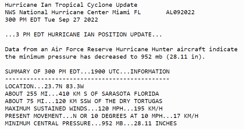
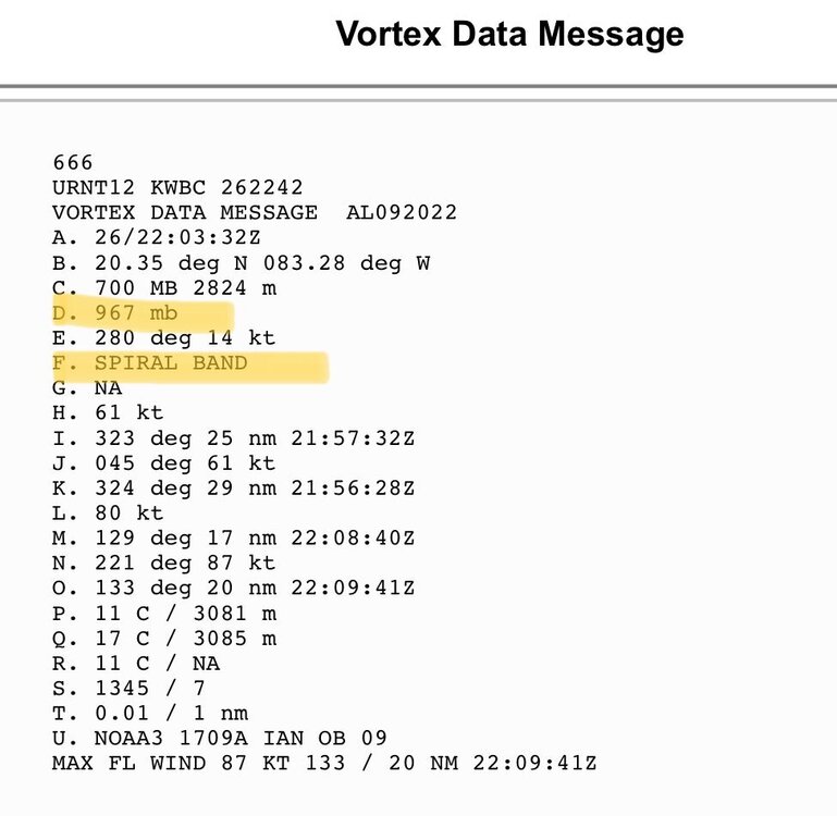
latest recon data shows that the pressure of Ian has continued to fall to about 966 mbar supporting the Cat 2 call by NHC NE quadrant is where the action is hottest. DMAX action tonight could goose it further. As is this is about 6 mb stronger than what NHC published at 5 pm
-
Recon flights are headed into Ian now. Always good to see Cuba allow NOAA to use its airspace to recon these storms.
-
Satellite probably suggested even higher perhaps?
-
From NHC discussion 5 pm 2. There is the danger of life-threatening storm surge along much of the Florida west coast where a storm surge warning has been issued, with the highest risk from Fort Myers to the Tampa Bay region. Residents in these areas should listen to advice given by local officials.
-
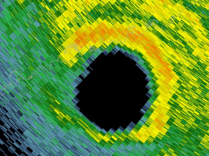
Eyewall is closed. If we luck out it will be in ERC mode when It makes an approach on the coast.
-
“National Hurricane Center director calls Ian forecast a "near worst-case scenario" for the Tampa area.” “This would be the storm of a lifetime for many Tampa Bay residents,” he added. for a long time I’ve admired the power of these beautiful storms. While I know they are destructive and deadly I still hold Nothing but awe. Looking at the visual on satellite today I have to say that Ian has more than earned my respect and if it goes on to destroy my home I will try not to be bitter or angry. A formidable cane is a thing of beauty for me. I’m sure I’m not the only one on this board who feels this way.
-
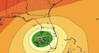
It’s bad enough that latest model runs took a further jog East. NHC incoming 5 pm will likely put TB dead center on their cone
-
What’s the over under that Ian gets retired after this week?


