

StormChazer
-
Posts
1,231 -
Joined
-
Last visited
Content Type
Profiles
Blogs
Forums
American Weather
Media Demo
Store
Gallery
Everything posted by StormChazer
-

MO/KS/AR/OK 2019-2020 Winter Wonderland Discussion
StormChazer replied to JoMo's topic in Central/Western States
12K and 3K NAM giving Tulsa a pretty hazardous morning commute(especially if that sleet verifies). -
MO/KS/AR/OK 2019-2020 Winter Wonderland Discussion
StormChazer replied to JoMo's topic in Central/Western States
Sure does look like something is shaping up in the vicinity just 1 week out, not bad odds, I'll take it for now. Also a surprise 3-4 inches in Tulsa this Friday on the latest run of the GFS. -
MO/KS/AR/OK 2019-2020 Winter Wonderland Discussion
StormChazer replied to JoMo's topic in Central/Western States
Euro and gfs both agree on a winter system coming through a week from tomorrow. I think this is the last storm I’ll give any hope into before calling it quits this winter. Now we wait. -
MO/KS/AR/OK 2019-2020 Winter Wonderland Discussion
StormChazer replied to JoMo's topic in Central/Western States
Euro just isn't biting on this at all. Someone is going to cave this weekend though. Will it be the GFS or Euro. Furthermore, who has performed better this season so far? Also, NWS in Tulsa. -
MO/KS/AR/OK 2019-2020 Winter Wonderland Discussion
StormChazer replied to JoMo's topic in Central/Western States
Well then... -
MO/KS/AR/OK 2019-2020 Winter Wonderland Discussion
StormChazer replied to JoMo's topic in Central/Western States
Tulsa gets about 3-4 inches of sleet and 1/2 of freezing rain on the GFS 12Z -
MO/KS/AR/OK 2019-2020 Winter Wonderland Discussion
StormChazer replied to JoMo's topic in Central/Western States
Shaping up to be another intense run of the GFS -
MO/KS/AR/OK 2019-2020 Winter Wonderland Discussion
StormChazer replied to JoMo's topic in Central/Western States
I hear you! Hahaha. I've been watching this time frame for a bit now, FV3 has overall been pretty consistent at making up for the last 4 years with this storm. GFS has the moisture more to the south, but nudge that precip shield up 150 miles and itll look about the same as the FV3. Euro has a small icy area in the Arklatex area but that's about it. 7 days out and all major models say there's cold air and precip, some join them together for a great day, some don't, but the ingredients are there. -
MO/KS/AR/OK 2019-2020 Winter Wonderland Discussion
StormChazer replied to JoMo's topic in Central/Western States
Keeping my eyes open at mid week next week(Feb 5-8). Looks like there's cold air and a storm swinging through the area around that time. GFS keeps it warm, Operational GFS throws snow and ice our way and the Euro is more northeast with the storm but does show some ice with snow way north. -
MO/KS/AR/OK 2019-2020 Winter Wonderland Discussion
StormChazer replied to JoMo's topic in Central/Western States
I LOVE IT! Haha, I'm snow starved so this is is like a sip of water in the desert. Is it enough? No, but it's enough to get me by just a little longer. I just stood outside my work staring up at the sky letting the flakes hit me. It's sad that it's come down to this, but it is what you make of it. Euro and operational GFS pickin up on some snow in OK next Friday. -
MO/KS/AR/OK 2019-2020 Winter Wonderland Discussion
StormChazer replied to JoMo's topic in Central/Western States
.DISCUSSION... A strong cold front is just about to enter the northwest corner of the forecast area, and this front will sweep southeast across the area this afternoon and evening. Scattered showers or areas of light rain will continue to increase in coverage ahead of the front, with a transition to a light wintry mix by later this afternoon and evening as temperatures fall below freezing. Have sped up the transition, and expanded the potential area affected by winter weather based on current trends, following the NAM12 for temperature trends behind the front. Will hold off on any advisories at this point, and continue to monitor trends over the next few hours. Update on the way. TSA -
MO/KS/AR/OK 2019-2020 Winter Wonderland Discussion
StormChazer replied to JoMo's topic in Central/Western States
HRRR 12z Edit: Just realized you posted a higher res of this, WeatherDemon. -
MO/KS/AR/OK 2019-2020 Winter Wonderland Discussion
StormChazer replied to JoMo's topic in Central/Western States
Hmmmm. Nam entertaining the idea of some snow after all up here. 1-2 inches with a very narrow band of 6 inches. If the low closes off, someone in NE OK/NW AR may get a surprise out of this. Not holding onto my breath though. -
MO/KS/AR/OK 2019-2020 Winter Wonderland Discussion
StormChazer replied to JoMo's topic in Central/Western States
TSA Discussion DISCUSSION... Forecast focus remains squarely on the strong storm system set to move through Friday night and into Saturday, with strong thunderstorms, accumulating snow, significantly colder temperatures, and low wind chills all possible. Models continue to struggle with consistency in timing and the eventual path of the surface and upper level features, and as such, low confidence remains in the details surrounding this event. Presently, low stratus deck continues across most of the forecast area, with expansion of the cloud deck likely to lead to at least mostly cloudy skies most locations by daybreak. Expect cloudy skies to persist for much of the day as low level moisture expands ahead of a fast moving disturbance that will push through the region tonight. Have kept toward the lower end of guidance for temperatures today due to the expected cloud cover. Showers and/or drizzle will be possible overnight as the disturbance moves through. Clouds should diminish some behind the disturbance, resulting in highs expected to be a few degrees warmer than today. Cloud cover will increase again from the west during the day Friday as the stronger system approaches, with the initial rain still expected to hold off until the afternoon. Isolated thunderstorms ahead of the approaching cold front still look to be a good bet, especially across southeast Oklahoma, given forecast instability. Any strong thunderstorm potential should be limited to areas near the Red River, where CAPEs of 500-1000 J/kg are currently forecast. With the current models trending slower, the thunderstorm potential will linger into early Saturday morning. This slower trend will also delay the onset of any notable wintry precipitation until after daybreak Saturday. It continues to look like most areas will see rain with a transition to snow, although there still looks like there could be a narrow buffer time frame when freezing rain/sleet could be possible. Accumulations of either will be negligible with snow dominating in the wintry precipitation department. Besides the slower model trend, there is also a more southerly trend than the 15/00Z suite, more like the 15/12Z suite. If this trend holds, this could place the maximum amounts in eastern Oklahoma farther south than the Kansas border and perhaps similarly in northwest Arkansas. For now, will go with a broad brush 2 to 3 inch area north of I-40 given the difficulty in pinpointing where any snow band might set up. Precipitation remains likely to move out by early Sunday morning. With regards to the expected cold temperatures, the cold air intrusion does not look quite as strong this morning as it did 24 hours ago. Forecast temperatures from Saturday night into early next week will be a few degrees higher this cycle but not significantly so. The likelihood of single digit wind chills late Saturday night and early Sunday morning remains high. There will be a good warmup early next week immediately ahead of the next system set to move through Tuesday and into Wednesday. This system will have some winter weather potential as well, although details with this one are even more uncertain than the weekend system. -
MO/KS/AR/OK 2019-2020 Winter Wonderland Discussion
StormChazer replied to JoMo's topic in Central/Western States
For those interested, here is the average(mean) of all 50 ensembles over the last 5 runs of the Euro. As you can see, there is definitely a trend to higher amounts in NE Oklahoma. In order from oldest to newest. -
MO/KS/AR/OK 2019-2020 Winter Wonderland Discussion
StormChazer replied to JoMo's topic in Central/Western States
While I never got my hopes up for this system for Tulsa. Seeing that if the forecast was just 2 or so degrees cooler we could be looking at some amazing snow is frustrating. Feels like wasted opportunities. -
MO/KS/AR/OK 2019-2020 Winter Wonderland Discussion
StormChazer replied to JoMo's topic in Central/Western States
Anyone wanting to see where the snow is via visible satellite today.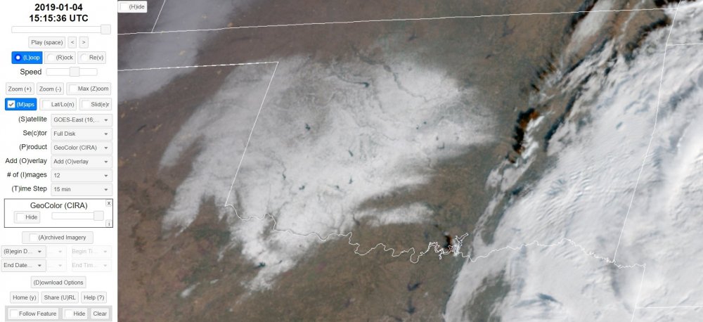
-
MO/KS/AR/OK 2019-2020 Winter Wonderland Discussion
StormChazer replied to JoMo's topic in Central/Western States
Happy for my OKC friends, disgusted for my fellow Tulsans.....that system had SO much potential. BUT, the season is still young! Just have to keep looking towards the future. The year with the most, highest snowfall totals is February. So we still have plenty of time! -
MO/KS/AR/OK 2019-2020 Winter Wonderland Discussion
StormChazer replied to JoMo's topic in Central/Western States
Euro hits Tulsa with nearly 1/2 inch of freezing rain and then buries it in 7 inches of snow. OKC gets hammered too. -
MO/KS/AR/OK 2019-2020 Winter Wonderland Discussion
StormChazer replied to JoMo's topic in Central/Western States
Thanks for sharing that. New Euro is coming in, and continues the trend since last night. It now encapsulates Tulsa in the snow zone. -
MO/KS/AR/OK 2019-2020 Winter Wonderland Discussion
StormChazer replied to JoMo's topic in Central/Western States
Yeah, very unprepared, but after the bust in December, I think all the Mets were trying to play it extremely safe. I’m very concerned about tomorrow. HRRR and meny other models are kicking out a ton of sleet and freezing rain on Tulsa. -
MO/KS/AR/OK 2019-2020 Winter Wonderland Discussion
StormChazer replied to JoMo's topic in Central/Western States
Wow really? Do you have any link or way to look into that pile up more? -
MO/KS/AR/OK 2019-2020 Winter Wonderland Discussion
StormChazer replied to JoMo's topic in Central/Western States
One of the local Mets here in Tulsa seems pretty unconvinced that we could get in on anything but rain tomorrow. Models definitely seem to suggest otherwise though. Latest gfs dumps an unholy amount of freezing rain and sleet on Tulsa. -
MO/KS/AR/OK 2019-2020 Winter Wonderland Discussion
StormChazer replied to JoMo's topic in Central/Western States
Yeah, it'll be interesting to see if the sleet in OKC makes it up to Tulsa, it's certainly cold enough for it. -
MO/KS/AR/OK 2019-2020 Winter Wonderland Discussion
StormChazer replied to JoMo's topic in Central/Western States
HRRR is constantly spitting this thing out quicker than the NAM. Here's 8AM on the HRRR And here's 8AM on the NAM. The NAM is lagging behind by about 4 hours right now, which in this scenario, where a single degree makes a world of difference, that's pretty substantial.


