
Bosswx
-
Posts
163 -
Joined
-
Last visited
Content Type
Profiles
Blogs
Forums
American Weather
Media Demo
Store
Gallery
Everything posted by Bosswx
-
Looking all rain for me as of now.
-
CMC way north.
-
More than 4" from these two storms and im done with winter. Bring on spring after that.
-
Fv-3 screws anyone south of Trenton.
-
Fv-3 screws anyone south of Trenton.
-
Gfs and Icon have me right on R/S line a mile north of me would have 7" and 1 mile south would have 4"
-
3k has a heavy band that goes through south of 1-195.Should help accumulate on roads.
-
Hoping for some snow Friday. Looks good on the Nam but then again its the NAM. Expecting to get screwed on the Monday threat, the usual N and W get snow while I get 33 and rain.
-
Im at 12.1" for the season here.
-
DUMPING here. Looking out the window is hypnotizing. Temp dropping down to 29.8 and rh rose to 76%. I think this would definitely be a 1" hr band or more.
-
DUMPING here. Looking out the window is hypnotizing. Temp dropping down to 29.8 and rh rose to 76%. I think this would definitely be a 1" hr band or more.
-
I went bold. 3-6" is still definitely possible for us.
-
Hoping this doesn't trend way north. Id like to keep it a little south of where the 12k nam is now. Thinking 2-4" for me.
-
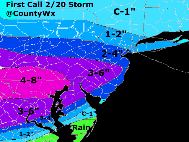
First call snow map. Will probably be updated tomorrow.
-
Think dry air may be a problem? The high will be lingering around until the precip shield comes in.
-
Raining in Toms River now after sleet.
-
Gfs and Fv-3 would get me back to almost average.
-
Still sleeting in Toms River. Not accumulating though.
-
Parts 1 and 2 Obs - 2/10-2/12 Winter Storm
Bosswx replied to KamuSnow's topic in Philadelphia Region
Hope this doesn't all melt before the evening. Had 2" before leaving. -
Hug the Navgem! Lol
-
Looks like a fun weekend of tracking!
-
Nothing here yet. Got down to 3 last night.
-
The only threat I have left from this storm is a flash freeze. Oh well, onto the next.
-
The storm isn't even onshore yet. Once it is hopefully we can get a better idea from the models.
-
Ended up with 1.75" not a bad event.
