PositiveEPOEnjoyer
-
Posts
509 -
Joined
-
Last visited
Content Type
Profiles
Blogs
Forums
American Weather
Media Demo
Store
Gallery
Everything posted by PositiveEPOEnjoyer
-
Spring 2024 Medium/Long Range Discussion
PositiveEPOEnjoyer replied to IWXwx's topic in Lakes/Ohio Valley
you can’t really ignore the MJO imo. phase 6 is quite a strong warm signal for this time of year even when taking into account the ENSO. don’t really care what that awful new AI model is showing at hour 336 or whatever. -
Spring 2024 Medium/Long Range Discussion
PositiveEPOEnjoyer replied to IWXwx's topic in Lakes/Ohio Valley
MJO really doesn't support it, but we'll see. -
Spring 2024 Medium/Long Range Discussion
PositiveEPOEnjoyer replied to IWXwx's topic in Lakes/Ohio Valley
at this point, I'll believe it when I see it. Same exact thing was supposed to occur last month and we all know how that turned out. -
2024 Short/Medium Range Severe Weather Discussion
PositiveEPOEnjoyer replied to Chicago Storm's topic in Lakes/Ohio Valley
you can continue to shoot yourself in the foot. fine by me. -
2024 Short/Medium Range Severe Weather Discussion
PositiveEPOEnjoyer replied to Chicago Storm's topic in Lakes/Ohio Valley
yeah, @Chicago Storm was right in saying that you should read more and post less. -
March 2024 General Discussion
PositiveEPOEnjoyer replied to MazooWeather's topic in Lakes/Ohio Valley
I've come to learn that the OP GFS is just a god-awful model. I wouldn't really take whatever it's showing in the medium-long range seriously. Although to be fair, the other deterministic models are quite putrid too. -
February 2024 General Discussion
PositiveEPOEnjoyer replied to Spartman's topic in Lakes/Ohio Valley
very disappointing, and also a bit surprising that ORD "only" topped out at 74 today. -
I wouldn't bet on it. Besides the CFS being garbage, long range modeling has been way too cold this season, and has also had a tendency to overdo the extent of high-latitude blocking. If anything, I wouldn't be surprised if the overall warm pattern continues to strengthen as the month progresses (especially if we get a high amplitude MJO wave to traverse through phase 6). Our source region is rather iffy, and with a lack of meaningful snow cover throughout the CONUS combined with warm soil temps, things could get really out of hand.
-
February 2024 General Discussion
PositiveEPOEnjoyer replied to Spartman's topic in Lakes/Ohio Valley
I think KRFD is running a bit warm. Still impressive tho -
February 2024 General Discussion
PositiveEPOEnjoyer replied to Spartman's topic in Lakes/Ohio Valley
I'm sure they can handle one coldish day before the next torch comes in shortly afterwards. -
February 2024 General Discussion
PositiveEPOEnjoyer replied to Spartman's topic in Lakes/Ohio Valley
impressive
-
DCA: +4.7 NYC: +5.3 BOS: +5.5 ORD: +7.5 ATL: +2.0 IAH: +2.4 DEN: +2.5 PHX: -1.0 SEA: +0.7
-
Winter 2023/24 Medium/Long Range Discussion
PositiveEPOEnjoyer replied to Chicago Storm's topic in Lakes/Ohio Valley
The models (particularly the Euro/Eps) have done a horrendous job in handling the Pacific for a while now, so this is no surprise. -
Winter 2023/24 Medium/Long Range Discussion
PositiveEPOEnjoyer replied to Chicago Storm's topic in Lakes/Ohio Valley
the GFS completely obliterates the PV as well.
-
February 2024 General Discussion
PositiveEPOEnjoyer replied to Spartman's topic in Lakes/Ohio Valley
I think the March 2012 heatwave was at least a 1 in 4000-year weather event based on the studies I’ve read on it. -
Winter 2023/24 Medium/Long Range Discussion
PositiveEPOEnjoyer replied to Chicago Storm's topic in Lakes/Ohio Valley
You should work on keeping your temper under control, as I’ve done nothing to elicit such an emotional/defensive response out of you (my birth year has no relevance either). Anyway, the last few springs have finished on the warm side of average, featuring plenty of mild/warm days, so I’m not sure what the problem is. -
Winter 2023/24 Medium/Long Range Discussion
PositiveEPOEnjoyer replied to Chicago Storm's topic in Lakes/Ohio Valley
Not trying to be a dick but you need to keep your expectations in check considering you live in Michigan. -
Winter 2023/24 Medium/Long Range Discussion
PositiveEPOEnjoyer replied to Chicago Storm's topic in Lakes/Ohio Valley
wrong

-
Winter 2023/24 Medium/Long Range Discussion
PositiveEPOEnjoyer replied to Chicago Storm's topic in Lakes/Ohio Valley
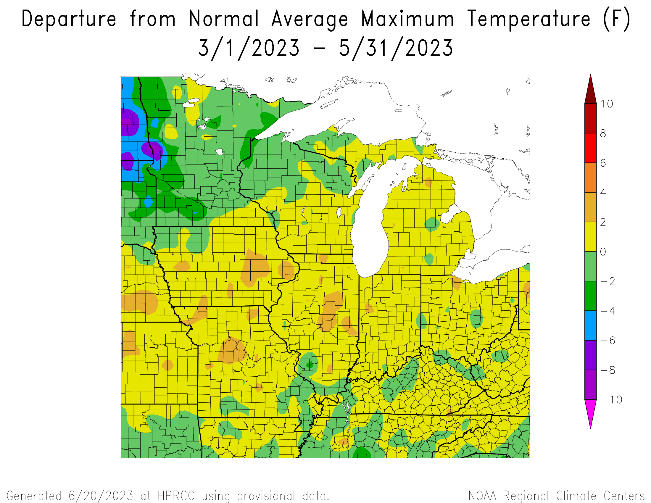
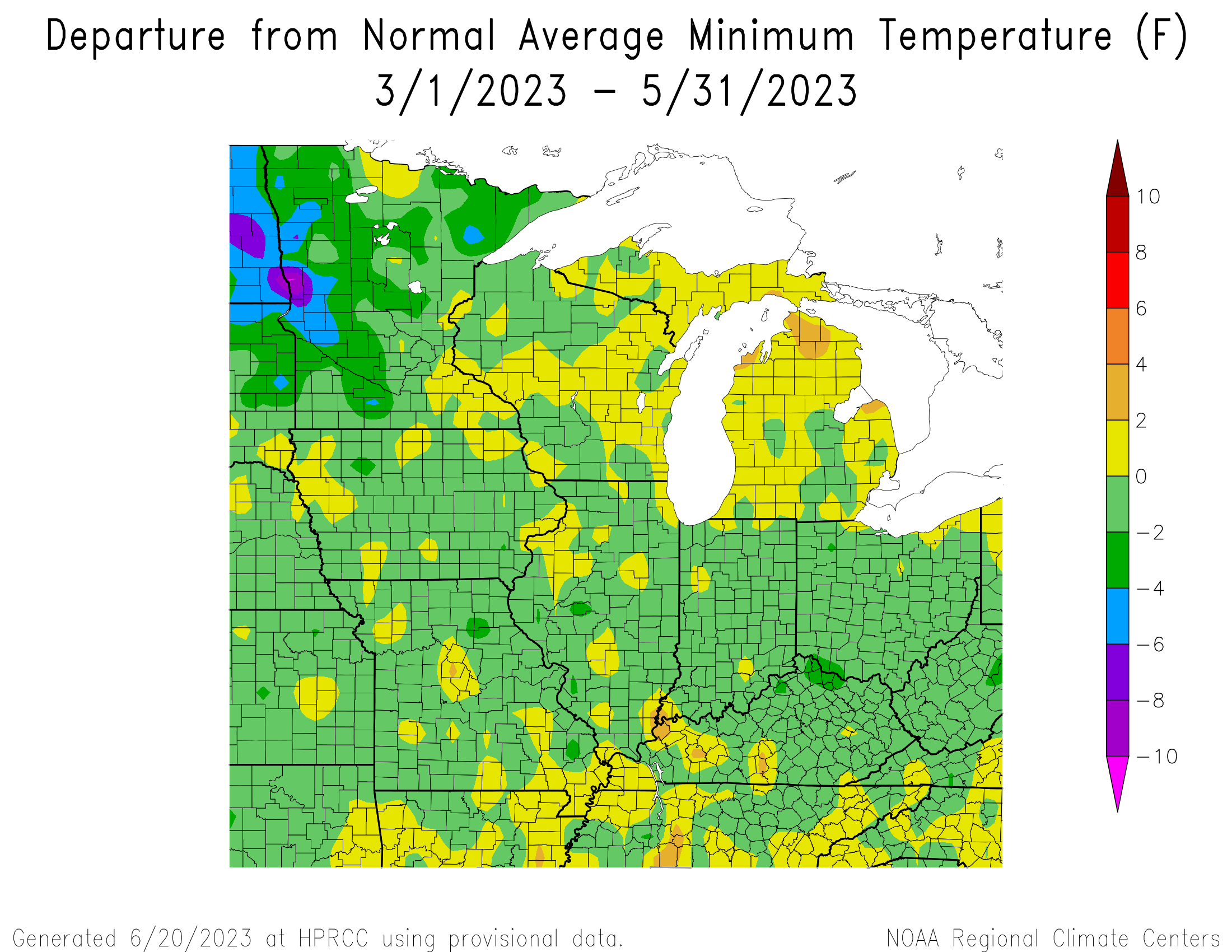
Last spring finished above average… -
Winter 2023/24 Medium/Long Range Discussion
PositiveEPOEnjoyer replied to Chicago Storm's topic in Lakes/Ohio Valley
My birthday’s also on the 11th, neat coincidence -
Winter 2023/24 Medium/Long Range Discussion
PositiveEPOEnjoyer replied to Chicago Storm's topic in Lakes/Ohio Valley
lol -
Winter '23-'24 Piss and Moan/Banter Thread
PositiveEPOEnjoyer replied to IWXwx's topic in Lakes/Ohio Valley
That dude is a fucking idiot lmao -
February 2024 General Discussion
PositiveEPOEnjoyer replied to Spartman's topic in Lakes/Ohio Valley
last I checked, 55-32 = 23 -
El Nino 2023-2024
PositiveEPOEnjoyer replied to George001's topic in Weather Forecasting and Discussion
interesting as Larry Cosgrove (along with some others) were hinting at the possibility of this March being very mild. Idk, just a bit skeptical of the cold March idea, but I guess we'll see. Probably doesn't mean much, but the super long range GEFS has a warm start to March as well.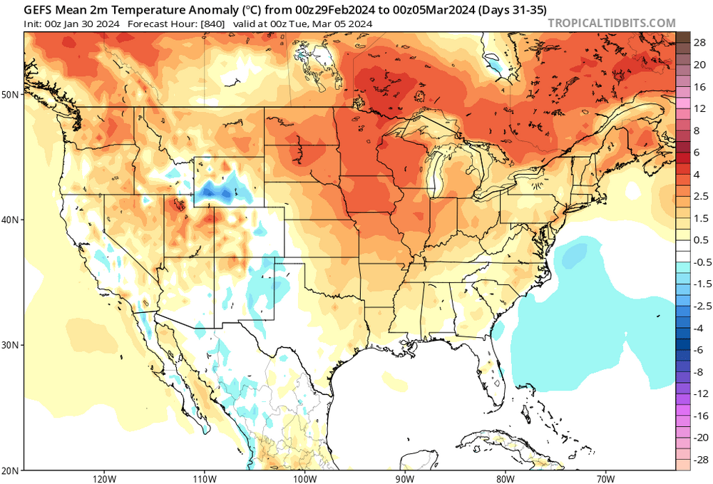
-
Winter 2023/24 Medium/Long Range Discussion
PositiveEPOEnjoyer replied to Chicago Storm's topic in Lakes/Ohio Valley
2021 was a nice spring overall, wouldn't mind a repeat of that.