PositiveEPOEnjoyer
-
Posts
509 -
Joined
-
Last visited
Content Type
Profiles
Blogs
Forums
American Weather
Media Demo
Store
Gallery
Everything posted by PositiveEPOEnjoyer
-
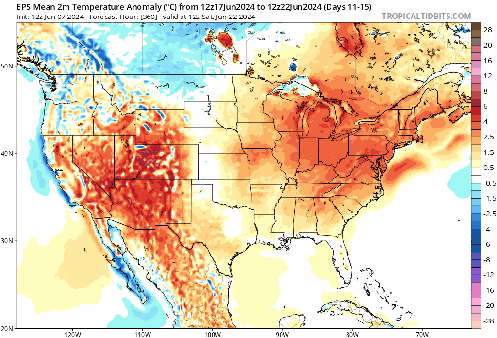
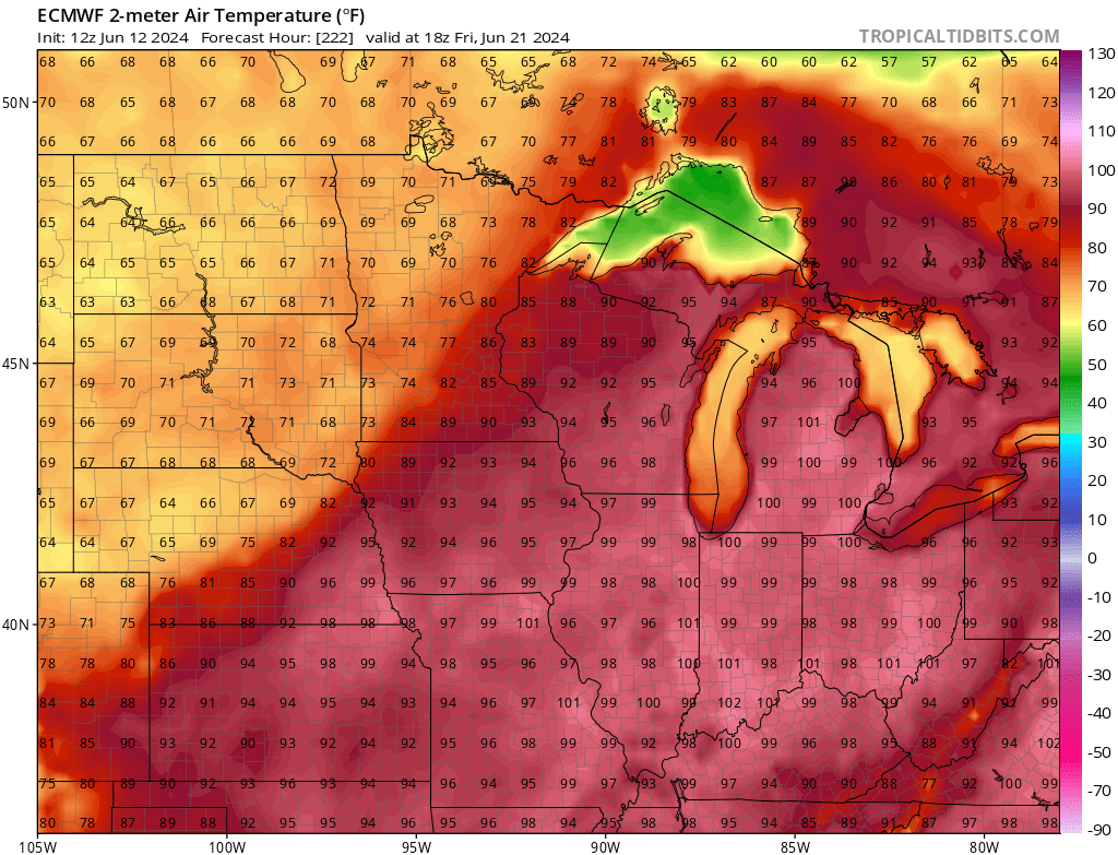
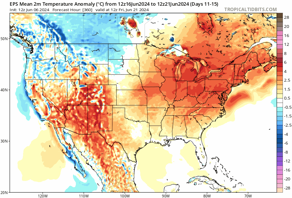
June 16th-21st (and beyond?) Heatwave
PositiveEPOEnjoyer replied to Geoboy645's topic in Lakes/Ohio Valley
should easily break the record high tomorrow at ORD given how temps performed today. 100 is probably just out of reach, though. -
June 16th-21st (and beyond?) Heatwave
PositiveEPOEnjoyer replied to Geoboy645's topic in Lakes/Ohio Valley
The GFS may as well be defunct. Hell, I wouldn't be surprised if the GEM was outperforming it at this point. -
June 16th-21st (and beyond?) Heatwave
PositiveEPOEnjoyer replied to Geoboy645's topic in Lakes/Ohio Valley
This is just a taste of what’s to come. July and August are going to be absolutely brutal -
continuing to trend hotter
-
Summer 2024 Medium/Long Range Discussion
PositiveEPOEnjoyer replied to Chicago Storm's topic in Lakes/Ohio Valley
enjoy.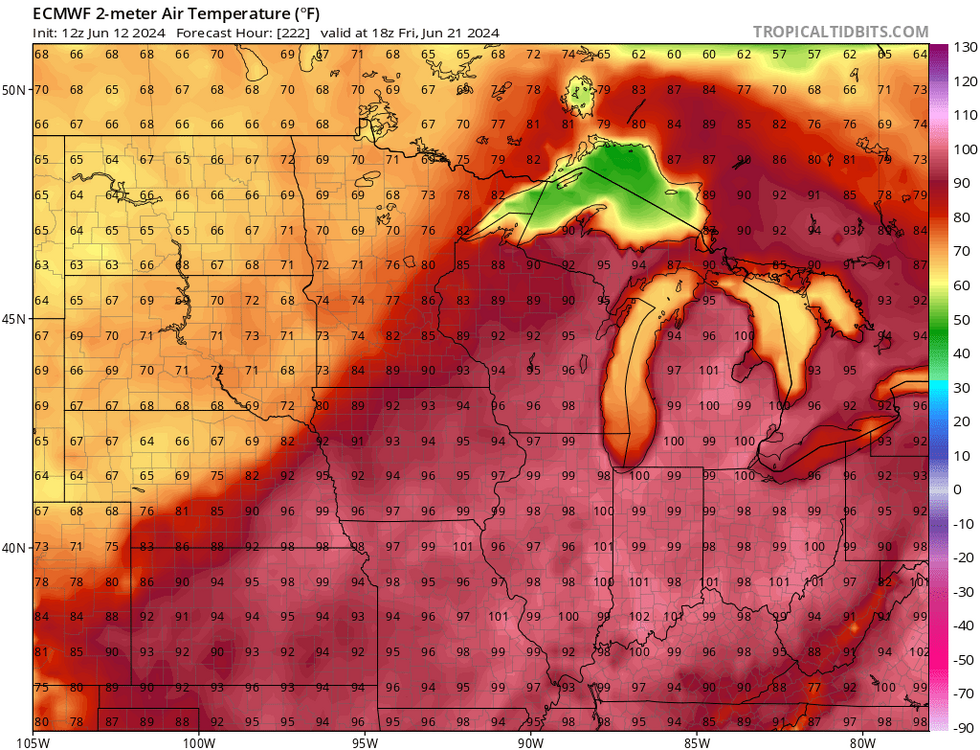
-
lol just stop, seriously
-
Summer 2024 Medium/Long Range Discussion
PositiveEPOEnjoyer replied to Chicago Storm's topic in Lakes/Ohio Valley
GEFS has been running too cold for a while now. It will correct warmer with time. -
Summer 2024 Medium/Long Range Discussion
PositiveEPOEnjoyer replied to Chicago Storm's topic in Lakes/Ohio Valley
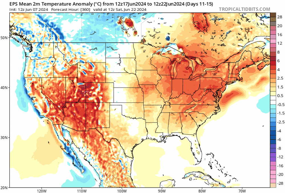
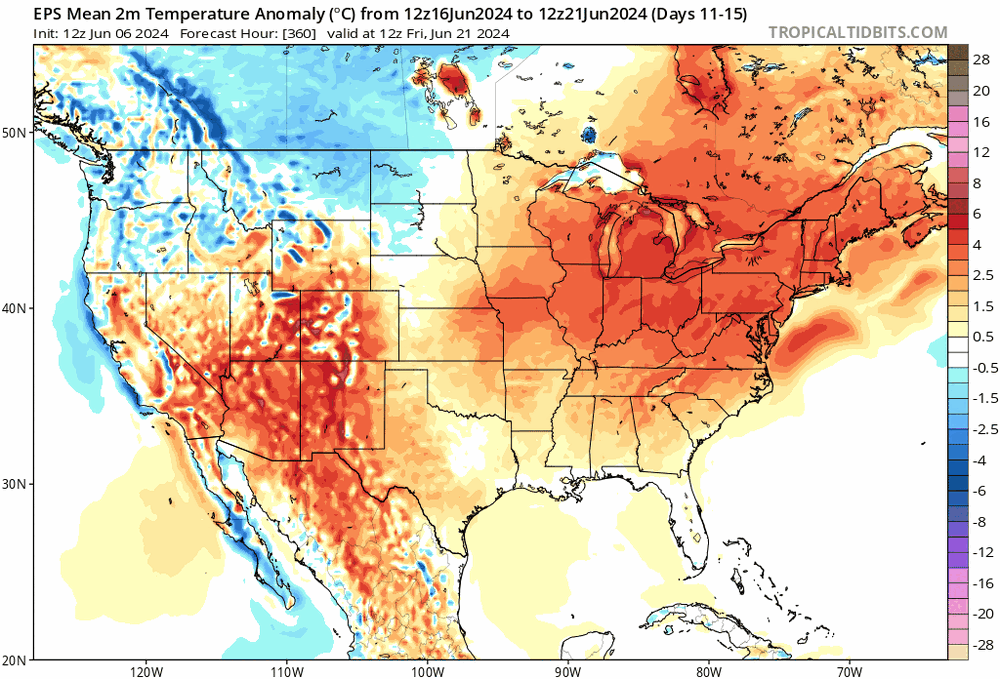
The pattern being modeled for the 2nd half of June is looking pretty ugly. The GEPS in particular is just an absolute blowtorch, and this is just a taste of what's to come. Can't even being to imagine what will happen in July/August when boreal summer teleconnections mature, but we'll see. -
Spring 2024 Medium/Long Range Discussion
PositiveEPOEnjoyer replied to IWXwx's topic in Lakes/Ohio Valley
Nah man, it’s not going to be the “it gets hot every year” type of heat, this year is different. It’s also not clear that this June will be “more moderate” yet. -
Spring 2024 Medium/Long Range Discussion
PositiveEPOEnjoyer replied to IWXwx's topic in Lakes/Ohio Valley
I'm not a big heat fan myself, but I honestly think some of you are in denial, no offense. There isn't a single variable that will lead to the avoidance of a death ridge this year. Check out the SSTs/OHC in the Gulf/SE region. Speaks for itself. -
Spring 2024 Medium/Long Range Discussion
PositiveEPOEnjoyer replied to IWXwx's topic in Lakes/Ohio Valley
100% expected actually given upcoming MJO progression/tropical forcing response. Won't last long tho, so enjoy. -
DCA: +2.0 102 NYC: +1.8 100 BOS: +1.7 99 ORD: +2.4 104 ATL: +1.5 102 IAH: +2.0 107 DEN: +2.4 104 PHX: +1.8 120 SEA: +1.3 99
-
Spring 2024 Medium/Long Range Discussion
PositiveEPOEnjoyer replied to IWXwx's topic in Lakes/Ohio Valley
This summer (and likely autumn) is going to be a literal torch fest for the entire country (except Alaska), and it's actually starting to concern me. Even without factoring climate change into it, the state of tropical forcing and internal variability itself favors heat to a rather extreme degree this year. Enjoy the next few weeks because it's looking ugly afterwards. Worth noting that 1988 happens to be one of the better analogs for this summer, which is rather unfortunate as a modern 1988 regime would be potentially catastrophic. -
May 2024 General Discussion
PositiveEPOEnjoyer replied to HillsdaleMIWeather's topic in Lakes/Ohio Valley
I would not be surprised if this ends up being the hottest summer on record for this sub. Niña onset with descending +QBO is pretty much a guarantee for a blowtorch summer, though I don't think we see much in the way of extreme heat until later on in July/August. -
Spring/Summer '24 Banter and Complaint Thread
PositiveEPOEnjoyer replied to IWXwx's topic in Lakes/Ohio Valley
none whatsoever here -
Spring 2024 Medium/Long Range Discussion
PositiveEPOEnjoyer replied to IWXwx's topic in Lakes/Ohio Valley
so bad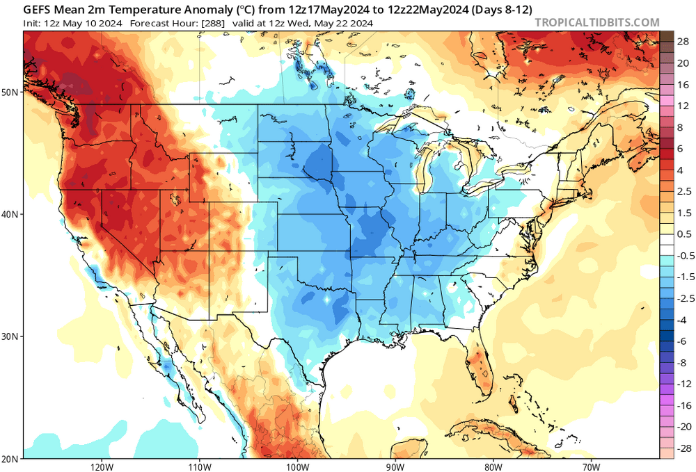
-
It's been a wonderful spring here in the Midwest. Sorry to hear it hasn't been as nice on the EC.
-
May 2024 General Discussion
PositiveEPOEnjoyer replied to HillsdaleMIWeather's topic in Lakes/Ohio Valley
I get that 2012 was technically warmer due to the freak March heatwave, but as a whole, I actually prefer this spring over 2012 in my area specifically. -
May 2024 General Discussion
PositiveEPOEnjoyer replied to HillsdaleMIWeather's topic in Lakes/Ohio Valley
This might just be the nicest spring I've ever experienced in my lifetime. Springs around these parts tend to not be very pleasant, but this one has been an exception for sure. -
Spring 2024 Medium/Long Range Discussion
PositiveEPOEnjoyer replied to IWXwx's topic in Lakes/Ohio Valley
Still doesn't change the fact that it's been one of the warmest springs on record for this sub as a whole, with the mild (albeit on the wet side) pattern looking to continue for the foreseeable future. -
Spring 2024 Medium/Long Range Discussion
PositiveEPOEnjoyer replied to IWXwx's topic in Lakes/Ohio Valley
AI models suggesting we see some legit heat towards the final week of the month. Either way, looks seasonable to above average for the most part. -
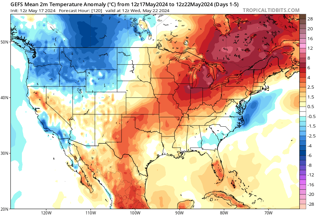
Spring 2024 Medium/Long Range Discussion
PositiveEPOEnjoyer replied to IWXwx's topic in Lakes/Ohio Valley
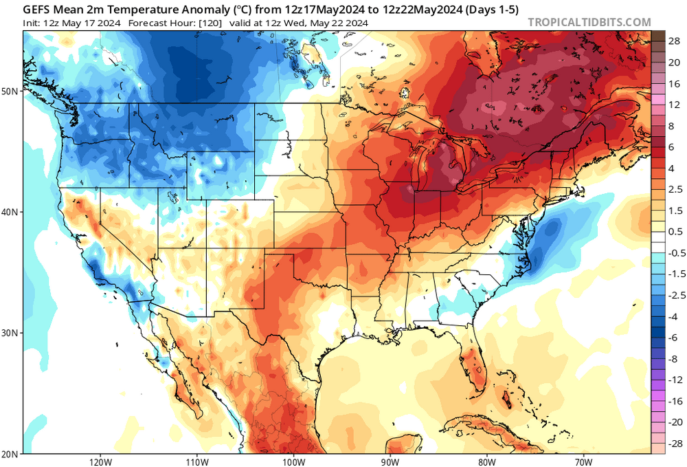
good to see the models are still horrendously cold biased. -
April 2024 General Discussion
PositiveEPOEnjoyer replied to PositiveEPOEnjoyer's topic in Lakes/Ohio Valley
ORD is currently running a +2.4 departure and will likely finish around +3, good for a top 15 warmest April on record. That's a bit more than just "slightly above" imo. -
April 2024 General Discussion
PositiveEPOEnjoyer replied to PositiveEPOEnjoyer's topic in Lakes/Ohio Valley
that actually happened not too long ago in 2014 when ORD finished right at -5. But yeah, hard to imagine that happening now. -
April 2024 General Discussion
PositiveEPOEnjoyer replied to PositiveEPOEnjoyer's topic in Lakes/Ohio Valley
the incessant downplaying of warmth on this board is really starting to get old.