

Henry's Weather
-
Posts
1,479 -
Joined
-
Last visited
Content Type
Profiles
Blogs
Forums
American Weather
Media Demo
Store
Gallery
Posts posted by Henry's Weather
-
-
Not sure what this difference means

-
Just now, Patrick-02540 said:
I loved that storm. Was in Woods Hole for that one and ended up with 14 or 15 if I recall.
It was my first sentient 2-footer
-
 1
1
-
-
1 minute ago, ORH_wxman said:
Yeah there are some similarities aloft. But Feb 2013 had a monster high to the north and this one doesn’t.
No doubt. We certainly won't make as much use for QPF as Feb 2013 did
-
1 hour ago, ORH_wxman said:
Not super similar but some of the variables are…Dec ‘92 had a strong ULL diving down through VA and this one comes in further north but due to the eastern southern stream low, we end up with an easterly flow for a time that is somewhat similar. Dec ‘92 had a potent high pressure up north too which while not very cold, it really increased the pressure gradient and helped cause the huge winds (90+ mph gusts on the exposed shore)
Airmass was pretty marginal in Dec ‘92 as well
I'm thinking that of all the big dogs synoptically, Feb 2013 might be an excellent match: (antecendent cold nonwithstanding)

-
2
-
-
With the boob phenomenon, this gets complex, but still can clearly see consensus on a capture and loop near the cape

-
1
-
-
1 minute ago, FXWX said:
I think the issuance of specific snow amount maps at this time is unwarranted and does more harm than good. The numbers on the these maps are going to change over the next 2 days, and when they do, all folks are going to remember is how much snow was predicted for their backyard and now it has changed. It leads folks mocking forecasters; they don't care about the reason, all they know is the number change? I am ok with forecasters issuing FIRST CALL outlooks with appropriate caveats. At this stage of the game, I think it is completely acceptable to use general probability terms on maps. Here some of the terms I'm using... Ex. Moderate to High probability of heavy snow of at least 10 inches; Moderate to high probability of seeing less than 10 inches; Moderate probability of seeing excessive snow totals more than 15 inches;. Of course the numbers I'm using are subjective. I fully understand the desire for numbers and the now expected call for media folks to post them. But we posting numbers long before we have reasonable confidence in those numbers verifying. A storm like this is a prime example of why many times you need to play it close to the vest. Again, first call maps like 40/70's with his detailed discussion and caveats are fine, but I guarantee there maps being posted now that will undergo major revisions over the next 2 days. Just some ramblings of an old forecaster; lol
This makes a lot of sense, agreed
-
Just now, Ginx snewx said:
These girls with far away eyes. 34 spot in the Berks

More like 28 spot but who's counting?
-
1
-
-
Would be cool to see a true rain to pounding snow event... not common these days
-
@ORH_wxman How similar is this evolution to Dec 1992?
-
Just now, weathafella said:
Lol..I was 46.
My parents were 12
-
1 minute ago, weathafella said:
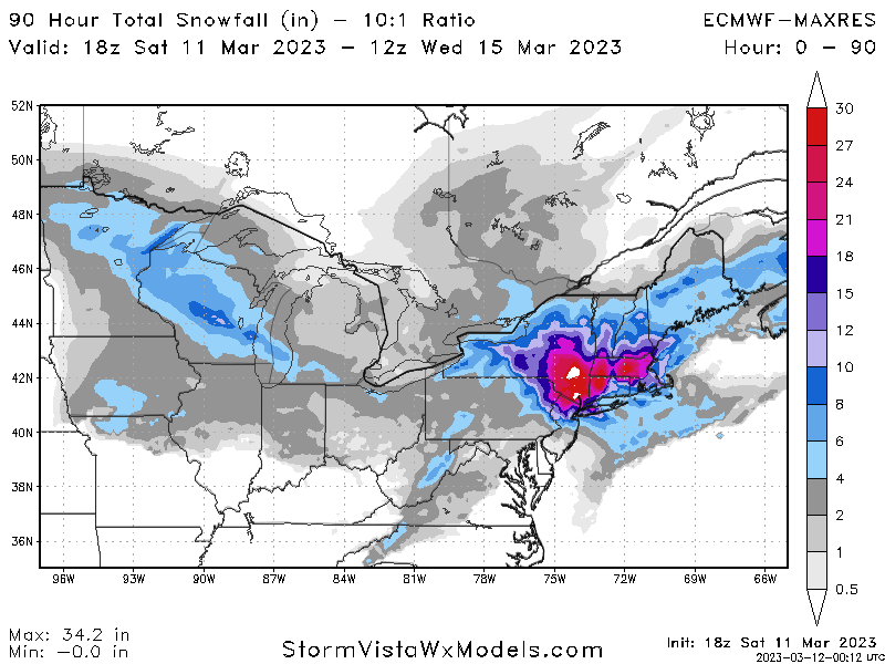
December 92 is walking through that door (? Wasn't alive then)
-
Just now, weathafella said:
I’ll tell you-69 hours it’s flipped in BOS.
12+ hours of thumpage in the metro
-
-
Just now, MJO812 said:

lock it.
-
1
-
-
19 minutes ago, EMontpelierWhiteout said:
Yes, it's a balance between maintaining credibility and giving crews enough time. Logistically speaking, this winter has not required much salt and the like, so maybe less time is needed
-
2 minutes ago, EMontpelierWhiteout said:
Maybe they are being objective, rather than looking through thick snow goggles.
"Objective" is different than being responsible for damage-control. The NWS can't forecast a snowy solution for borderline areas because they are responsible for public works' mobilization, not because they are strictly following guidance. Strict adherence to guidance = "objective", only yields a snowier forecast than the one they put out. They are more conservative not for the purpose of fundamental accuracy, but for risk management at this distance
-
 1
1
-
-
9 minutes ago, CoastalWx said:
This is amazing. So many solutions.
Such a cool system, stepping aside from IMBY insecurities. Pinwheels and pinwheels
-
Just now, weathafella said:
What? Lol
Must be some spring time zone mischeviousness
-
Who needs a pingpong table when you have tropicaltidbits.com?
-
It is nice though to see that we still certainly need highly discerning meteorologists to interpret computer outputs.
-
My God, I'd hate to have to make a forecast for the general public on this one.
-
1
-
-
All in all, we can see that the envelope of possibilities is still very wide. Going to probably be another 24 hours before more clarity emerges
-
1
-
-
Just now, ORH_wxman said:
I did too…but nuances are gonna be a pain in the ass to deal with on this storm.
Proud of this, lol
-
Just now, Damage In Tolland said:
It’s a great run if you are looking for a monster hit and all snow
Verbatim, that's a bunch of CCB all the way back to the river, perhaps even further


The last hurrah? Putting all the eggs in the Tuesday 3/14 basket
in New England
Posted
Changes between 18z and 0z are thus far not insignificant