

Henry's Weather
-
Posts
1,576 -
Joined
-
Last visited
Content Type
Profiles
Blogs
Forums
American Weather
Media Demo
Store
Gallery
Posts posted by Henry's Weather
-
-
Seems very out of step with all of the guidance
-
1 minute ago, 40/70 Benchmark said:
I may see some CF enhancement Tuesday AM.

Cooking up an update?
-
Just now, George001 said:
Doesn’t look very east to me, the low is NW of the benchmark by a decent amount
He's a troll
-
 1
1
-
-
2 minutes ago, MuddyWx said:

Big boy evolution. Talking Darwin levels.
-
Just now, 40/70 Benchmark said:
What tells you all you need to know about the BL not being much of an issue is that Kuchera is now a bit more aggressive than 10:1.
All about explosiveness in the DGZ. You know this, obviously.
-
2 minutes ago, 40/70 Benchmark said:
Not unless you are on the outside looking in....if the storm materializes as forecast, it won't matter one iota.
Yep, dynamics trump sun angle, anyday
-
 1
1
-
-
1 minute ago, 40/70 Benchmark said:
Hopefully with that a stream, the QPF lift a bit more north than progged.
973 low on the arm of the Cape, Idk if you're gonna be struggling with QPF
-
1 minute ago, wxsniss said:
18z Tues:
925mb winds:

Surface:

Pretty, pretty good
-
Cue the accordion dude freaking out, asking if he should get on a plane

-
1
-
 1
1
-
-
-
3 minutes ago, MuddyWx said:
GEFS east with OP
Really good look here.
-
1
-
-
Might go nuts at hr 78
-
11 minutes ago, 40/70 Benchmark said:
Lol imagine if the s stream was just an artifact of modeling all along....waa wa waaaaaa
Not looking like it

-
Gonna go kablam

-
-
1 minute ago, STILL N OF PIKE said:
I don’t think nam is gonna do much north of route 2 here . I’m at hr 48
Wish pivotal wasn't such a b*tch to use on the phone
-
1
-
-
1 minute ago, Henry's Weather said:
Gonna be a cool run. Northern S/w further south, while southern s/w slightly more meriodonal. If I were to guess, this will be a slightly earlier phase and capture than last run, which should be right over the islands or Cape

Or however you spell it... meridional?
-
1 minute ago, DaDuke said:
Love seeing the multi-generational exchage of knowledge/experience on this thead!
Some of you are old as fuck... others just weening off the teet!!... lmao
Yeah it's a pretty awesome thing
-
Gonna be a cool run. Northern S/w further south, while southern s/w slightly more meriodonal. If I were to guess, this will be a slightly earlier phase and capture than last run, which should be right over the islands or Cape
-
1
-
-
My guess is she runs straight up thru Chatham

-
1
-
-
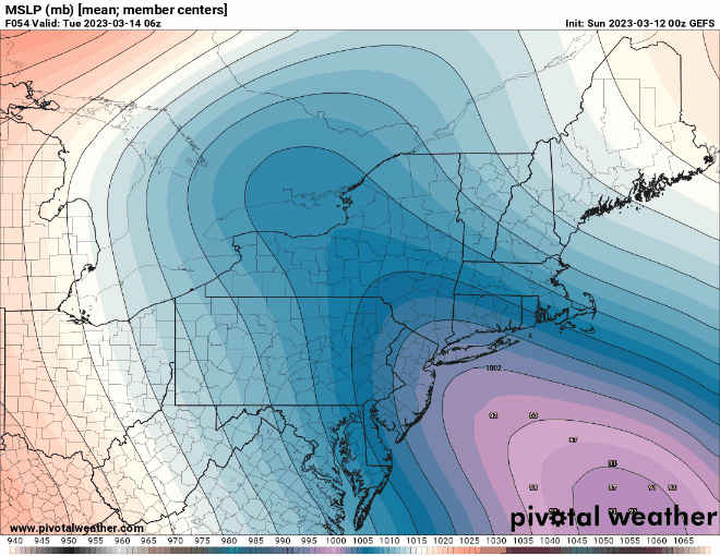
Changes between 18z and 0z are thus far not insignificant
-
Not sure what this difference means

-
Just now, Patrick-02540 said:
I loved that storm. Was in Woods Hole for that one and ended up with 14 or 15 if I recall.
It was my first sentient 2-footer
-
1
-
-
1 minute ago, ORH_wxman said:
Yeah there are some similarities aloft. But Feb 2013 had a monster high to the north and this one doesn’t.
No doubt. We certainly won't make as much use for QPF as Feb 2013 did


The last hurrah? Putting all the eggs in the Tuesday 3/14 basket
in New England
Posted
NAM makes landfall at Islip