

Henry's Weather
-
Posts
1,479 -
Joined
-
Last visited
Content Type
Profiles
Blogs
Forums
American Weather
Media Demo
Store
Gallery
Posts posted by Henry's Weather
-
-
Roughly 3-4 inches out there, moderate intensity now.
I swore I would never do this, but I’ve started to implement interval shoveling. It’s an easy way to eyeball rates too. Currently in the process of becoming crotchety and old, no offense to those here who fit that description
-
 2
2
-
 1
1
-
-
7 pm to 12:30 sleep completed, plan winter walk commencing. It’s pounding out here in West Concord, looks like about an inch from the window
-
15 minutes ago, RUNNAWAYICEBERG said:
Yea, usually tracking the storm produces more euphoria then the actual storm itself.See that’s what I try to avoid right there
-
Just now, STILL N OF PIKE said:
I recall that one well
Yeah it was the 15th
-
 1
1
-
-
3 minutes ago, weatherwiz said:
I swear doing stuff like that has come back to bite me hard. I mean I am constantly always fatigued now. It doesn't matter how much sleep I get. It actually really sucks. I used to go to bed like 2-3 AM and then wake up at 7 lol. I remember a few times staying up for like 2 days in a row

I think I was up for like 42 hours straight when the Dec 08 ice storm was going on.
Oh man, that’s even further than Ive ever been. Never done the 48 hour thing! Haha
-
1
-
-
Just now, weatherwiz said:
Unfortunately, my days of staying up all night are long gone, too old now. I really miss being able to do it. I think it was the 2013 blizzard I stayed up all night for...that was awesome. I miss the days of staying up late for the 0z models, especially during the summer. When I saw a severe threat several days out I never used to go to bed lol...I would just nap throughout the day. Bruins also play tomorrow night so I'll be having a 9% IPA or two so that will knock me down. Maybe I'll get an energy burst.
I think people differ in intensity of interest… ive always been the type to lose tremendous amounts of sleep up to a week out from potential events. You seem similar lol.
These days it’s easier to regulate due to having other things I care about lol. And realizing my fundamental lack of control over outcome despite desire.
-
2
-
-
2 minutes ago, weatherwiz said:
Thundersnow potential overnight drives me nuts. I've had a few occasions when I was a youngin' where I thought I heard thundersnow overnight and fell out of bed...only for it to be the plows. DAMN YOU PLOWS
Is the plan to stay up all night? I’m nyquilling at 7 pm tomorrow
-
About the same, solid warning event. Nice
-
Ooooh GFS is better. I’m forsaking my 6 am wakeup for this, better be good. Gotta get that eight hours
-
Just now, kazimirkai said:
What are WAA and CCB?
Preface: not a met, subject to error.
WAA= warm air advection. This mode of precipitation is caused by warm front mechanics, generally. Warm air moving northward. Pre-mature cyclone.
CCB: cold conveyor belt. This type of snow is a result of cyclonic curvature funneling moist air into the dendrite-forming column in the atmosphere on the cold side of a system. It occurs during the strengthening of a cyclone to near peak strength and continues once it reaches maturity.
subject to correction
-
50 miles more of latitude would’ve done it.
-
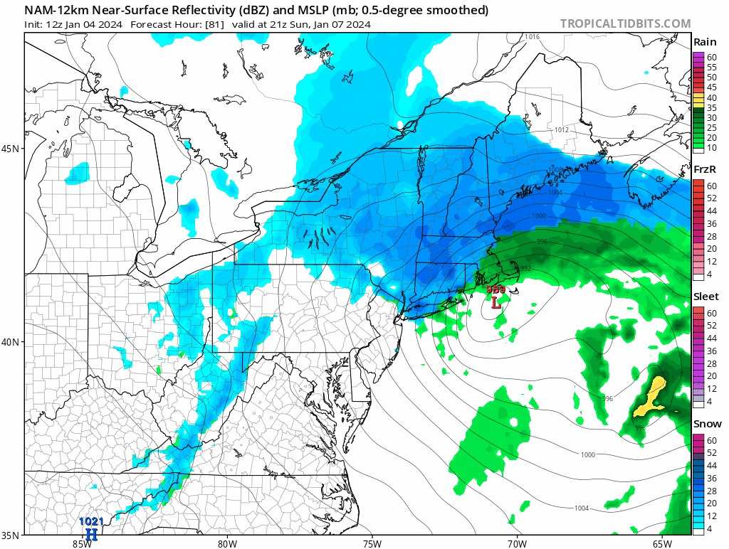
NAM is a whiff for WAA, not for CCB
-
2 minutes ago, CoastalWx said:
Ha, part 1 might whiff.
Definitely exchanging WAA for CCB these past few runs
-
Just now, dryslot said:
Quite bullish i might say,

Woah, that’s amped
-
1
-
-
Had some flurries come through recently, sets the tone for this weekend
-
Just now, Typhoon Tip said:
I thought the 12z was dubiously warm in the lower levels to be honest.
But this gets exhausting chasing the perfect scenario with with plausible excuse after excuse every 6 hours lol. Just letting these model runs come in at this point.
It’s pretty draining dopaminurgically.
-
General tilt seems more positive, slightly more separation between S/Ws. Should be less amped, good news for coastal crowd, bad news for dryslot and dendrite
-
 1
1
-
1
-
-
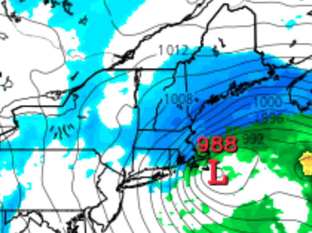
BOX should release their first suite of watches at 4 today, probably going to go for 6-12+ interior, 4-8 along coast excluding cape and islands
-
2
-
-
Folks who imagine that more than a swath of 6-12+ could materialize do not understand the fundamental synoptics of the event. This has never had the firepower to be a long-duration, multi-stream merger blizzard. The question is SECS or low-end MECS (meaning a zone of 12-15), which is entirely dependent at this stage on whether the trailing energy can interact with the initial WAA-causing pulse and close off H5 south of the coast to prolong CCB for a couple more hours. I’ve seen a couple insinuations of 1-2 feet from some here, who are woefully demonstrating their lack of comprehension of or experience with these type of systems.
-
 1
1
-
4
-
 1
1
-
-
-
Im on team CCB over WAA, welcome trend to me
-
1
-
-
That second wave interaction really gets it going

-
1
-
-
1 minute ago, dendrite said:
2nd verse same as the 1st?
Dont know what you’re referencing, but yeah
-
Just now, CoastalWx said:
NAM seems like it will be better with the second s/w interaction. Early predictions.
Glad to see we agree!

January 6-7, 2024 Winter Storm Obs Thread
in New England
Posted
I will say that the HRRR is trending towards less mixing each run for Boston metro