

WesternFringe
-
Posts
848 -
Joined
-
Last visited
Content Type
Profiles
Blogs
Forums
American Weather
Media Demo
Store
Gallery
Posts posted by WesternFringe
-
-
-
13 on my commute to work. 15 currently
-
 1
1
-
-
11 minutes ago, Terpeast said:
Is it like that for 3k too?
Yes, always is. I notice it when comparing Pivotal maps vs TT
-
48 minutes ago, WinterWxLuvr said:
Shame. Looks like Augusta County got the shaft.
We will see. That map my shows 3-4 imby in Augusta County and we tend to do well with actual thermals compared to forecast thermals here in the northwestern parts of the county at least.
-
5 minutes ago, jayyy said:
One thing is for sure… NAM has an actual system there, which is certainly better than 18z’s depiction of a non system
.Hopefully it is picking up on better thermals and the ops are right with the amplitude and track. At this range, both of these can be true
-
2
-
-
7 minutes ago, Terpeast said:
Happy to see the HH GFS, but kinda hard to get too invested when models can't even agree on what kind of storm this is going to be... or if there is even going to be one.
It really has been a difficult storm for the ops and the mesos to nail down specifics like thermals.
On the other hand, it seems the ensembles did well, since we have been tracking this specific sw for about 2 weeks now? Pretty impressive on their part.
It struck me this week that all of my coworkers have been and are aware of this possible winter threat from 5-7 days out. A lot of progress has been made from times in the 1960s when meteorologists would say light snow tomorrow in Staunton followed by 20+” the next day (in-law family stories)
-
1
-
-
21 minutes ago, aldie 22 said:
Just got back from the gym how are the trends?
Current trend is telling the thread how much the latest model gets you in your own backyard.
eta: looks about 9” for me! Lol
-
1
-
 1
1
-
-
26 minutes ago, WEATHER53 said:
So let’s get this thinking about models with some more responses.
It’s being proposed to me that models are not a weather forecast. I disagree. They are a “tool” to help forecasters devise a forecast. I disagree. Their programming and programmers is Not that way and they are Not 4/5/6 different model types all strung together to assist in formulating a forecast each 6 hour period. They are in fact their own prediction of what the weather will be at, for example, 18z Saturday. It’s not a clue nor hint to be strung together with other models to develop a forecast: It Is A Forecast .
Would you just give all the different models’ forecasts as your prediction then? Like if you were trying to make a forecast for 5 days out? Would you just list every possibility all the dozens of models threw out?
Or would you look at the guidance, use your knowledge of weather as a human, and know your climo well enough to use the models as tools to make your own forecast?
eta: sorry @jayyy , I wouldn’t have replied if I saw your suggestion first
-
19 minutes ago, WxUSAF said:
Could about walk from places with <1” to 8”. Razor thin gradient.
Yes, and if that lines sets up close to our backyards, we all hope it’s to our SE and we don’t have to walk to see snow.
-
6 minutes ago, Buddy1987 said:
GFS through 60 maybe looks to be a tad quicker with energy diving southeast out of Texas and slightly better confluence? What’s everyone think?
Def some southeastward progression at 72 with gulf low now..
Slightly better confluence in New England through 72
-
1 hour ago, Heisy said:
24 hour change lol

.Some of this looks like artifacts of timing to me, since the sw has sped up.
-
37 degrees and light snow here in Augusta County nw of Staunton
-
2
-
-
15 minutes ago, psuhoffman said:
1) I was responding to someone else who asked me a question
2) you took issue with it for some reason which I think you just made evident by the bolder part above.
3)Every post after my initial one is your fault. Don’t start a conversation then say “why are we discussing this”.
4) This isn’t a fight about climate change but now I think I understand your issue. You think it is.
5) I’m not talking about our snow chances if it was 20 years ago. I’m taking about what would help this week. And that’s a colder airmass. That’s the trend we need. That’s what was asked to me.
6) We need the same thermals we needed 50 years ago. The temperature water becomes solid hasn’t changed! I DGAF about 20 years ago except to examine what setups we need to get snow NOW!
7) How you gonna objectively assess a snow threat and ignore temperatures?
This became a drawn out thing because of you. You injected yourself into a reply to someone else. That’s fine it’s a public discussion thread. But you took one of the most ridiculous stances I’ve ever come across and kept doubling down on it and now that you have nothing left you turned to a personal attack and some silly “why you going on and on about this” argument when you’re the reason for the whole back and forth.
This is the silliest most illogical argument I’ve ever come across on here. And frankly I think we’re arguing two different things. I’m addressing what we need to snow next weekend and you’re having some anti CC crusade. I’m not cluttering up the main thread anymore with this nonsense. If you want to reply please do it here but I’m done.
Okay, man. You literally direct quoted me two times. I am not talking climate change, I am talking about your contributions to the mid range discussions and how they are super super repetitive and wear on everybody. And who cares if you are done?
-
 1
1
-
-
5 minutes ago, clskinsfan said:
The GFS is a legit weenie run. Like a crazy winter weenie run. Happy mofo New year~
It is about 40” for mby. Legit weenie run. Lol!!
-
2
-
-
3 hours ago, psuhoffman said:
This kind of proves my point...that the temps are the most important issue...the thing I don't get is you act like its a given we will always have temp problems...NO its not...There are plenty of times we had a cold enough antecedent airmass in place that was....wait for it...5-10 degrees colder than the one forecasted this week. And that's why it snowed those times and why it might not this time for many places!
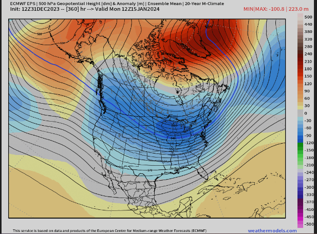
Look at where the thermal boundary is at 850 and surface as the wave approaches
Surface

850...and look where the REAL cold boundary is
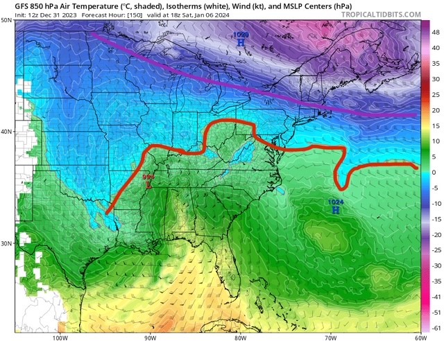
This is NOT what we want or need the thermals to look like as a wave begins its final approach...the WAA hasn't even kicked into high gear yet and were already too warm! We are left relying on everything else to be absolutely perfect to make up for the one main deficiency.
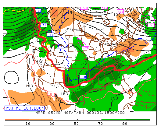
Look at what we WANT the thermals to look like as a strong wave approaches us from the southwest...just so we can remember what COLD ENOUGH looked like, what we actually want the thermals to look like.
January 1996
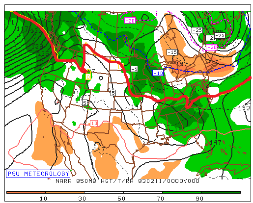
Ok maybe this isn't fair...it's one of our colder big storms and during a Nina. So here is a storm in another strong Nino during a very "warm" winter...at least by those days standards
Feb 1983
And finally...Feb 2010 and at the time this was considered to be a marginal airmass! I remember about 5 days before that event I was discussing with Wes weather the airmass would be cold enough, he thought it was problematic and we were debating if with a perfect track it would be able to overcome the "questionable" airmass... so this was considered marginal and the bare minimum of what we need to be cold enough to snow
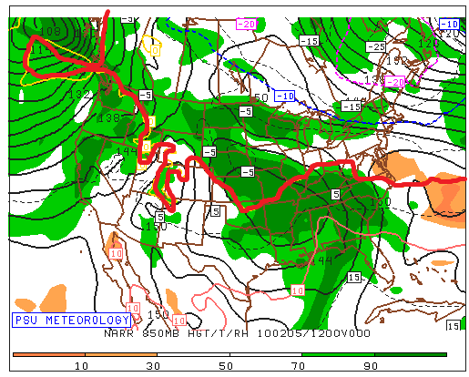
Still miles better than what we have leading up to this event on guidance.
So we could be super picky and analyze what we need from the SLP track and the upper low and the exact amplitude of the wave and the exact composition of the 50/50 and the western trough....but the one obvious flaw that makes it so that we need all that other crap to go 100% perfectly for us to get a big snow in DC is that its NOT COLD ENOUGH.
BTW the reason I have been saying this a LOT lately is because its been true a lot lately and its why its not been snowing much the last 7 years. This is the least edgy controversial thing Ive ever said. Its a melba toast comment. Its like DUH. There is no mystery to why we haven't been snowing as much lately.
THIS IS WHY...Temp anomalies Dec-Feb last 7 winters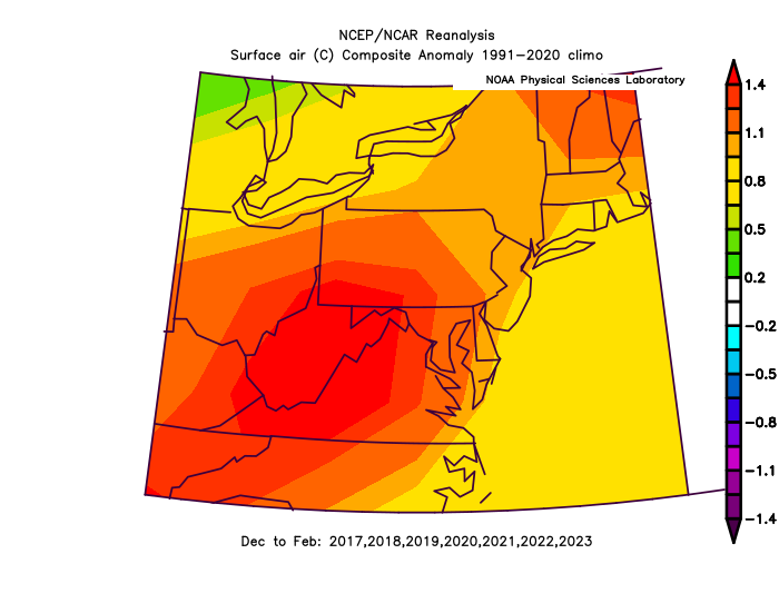
ITS THAT SIMPLE
Say it more. You have proven your point (at least to your self-satisfaction) literally hundreds of times. We all come here to talk about how it might snow and to have fun with it. What is the actual f-ing utility of saying the same thing over and over and over?
At a certain point, who cares if this used to be a snowier set-up? What we all care about is snow chances for next week. We don’t need an incessant and never-ending dissertation why it would have been a better set-up 20 years ago. Who fucking cares? Jesus christ.
Most of us just care about the fun of snow chances next week, and really don’t care where you think it fits historically at all or in the least little bit. This hobby is supposed to be fun and you are a kill joy at times.
It’s that simple.
-
2
-
 2
2
-
2
-
-
1 hour ago, psuhoffman said:1 hour ago, WesternFringe said:
I don’t know. But I know with the marginal thermal situation we need everything else to break near perfectly. 50/50 isn’t perfect rain. SW too amplified rain. Surface track inside at all…rain. I guess you can focus on all those variables but the one simple thing that would change all this in our favor would be if the airmass was maybe 5-10 degrees colder.
I was talking about when you said this. We all know this. Saying it would be different if it were 5-10 degrees colder is meaningless. Of course it would. You say this a lot.
-
1
-
-
27 minutes ago, psuhoffman said:
I’m talking about the DC Baltimore area. You’re a whole different world. And i never said I ever thought it would be colder. I’m just saying if we wanted to make this setup much more likely to end up snowy for DC v just a possibility if a bunch of stuff breaks right…having a colder antecedent airmass if the one variable that would do that. That’s not even controversial. Im not even sure what you’re taking issue with.
Because saying it would’ve been different if it were 5 to 10° colder on every storm in the winter is a meaningless thing to say. Of course it would. That goes for anywhere and any climo. So why keep saying it?
-
1
-
-
17 minutes ago, psuhoffman said:
I don’t know. But I know with the marginal thermal situation we need everything else to break near perfectly. 50/50 isn’t perfect rain. SW too amplified rain. Surface track inside at all…rain. I guess you can focus on all those variables but the one simple thing that would change all this in our favor would be if the airmass was maybe 5-10 degrees colder.
Straw man. When was it ever going to be 5-10 degrees colder in this setup? You and others even told us so from the get go.
ETA: it looks forecast to be cold enough out here to have a really good chance of accumulating snow west of 81. And also up the valley ene from me.
etaa: but what I don’t claim to know is the final result, which is why we all track. If you do know, it is kinda boring I would imagine
-
11 minutes ago, psuhoffman said:
I think the biggest problem is the antecedent airmass just isn’t cold enough for a good but somewhat flawed setup to work. We could over analyze whatever little thing causes this or that. But systems will try to find the Barcelona’s boundary. And the real boundary with the best gradient is to our north.
No one knows the final result yet. As depicted, you may be right, but who knows? It is hubris to think you know more than the models that are not even showing the final outcome yet.
The models don’t even agree with one another and you seem to weight the lowest verification score model (the GFS and it cousin the GEFS) as your bighest deb trend rationale.
-
Just now, DarkSharkWX said:
i know its snow mean but EPS at end of run looks really good, 7" snow mean and >30% chance NW of the fall line for over 6"


So, is winter still canceled?
-
2
-
-
4 minutes ago, Ji said:
If I see another 500mb map 13 days outWhy come to this thread then?
Or are you saying it is time for a separate Jan 6/7 thread? Yes, I said it. Lol
-
1
-
-
13 minutes ago, WEATHER53 said:
Shows6+ hours of snow in DC. How is that a trend of no snow?
Also some of this could be artifacts of timing. Would be more helpful to see a loop of 24 hrs from each run compared to one another
ETA: the increased snow on the Euro from 0z to 12z is something to watch. If it keeps looking like that, it might be a trend towards snowier outcomes for many in the MA
-
7 minutes ago, Weather Will said:
WB 12Z EPS. NW zones still in the game. Couple of big hits still area wide....


Can you get verification scores for the ensemble members anywhere? That would be fun data to have
-
9 minutes ago, WEATHER53 said:
Are you another self appointed corrector of other posters? We have a couple already and that’s enough
No, but I don’t call people names. Can you say the same?
You made a forecast, I commented on it. I still find it literally meaningless to forecast similar probabilities for 4 such disparate outcomes.
eta: and always will
-
1
-


January 6-7 Storm Discussion: we’re due?
in Mid Atlantic
Posted
Not sure what Stormy is looking at, but it was progged to begin as freezing rain/mix and flip to snow around 10:00 and then back to mixing around 12:00. Hoping to cash in on a couple inches of slop during the ‘good’ period.
TWC sent Jim Cantore to Staunton so it must be happening! Lol
eta: 30° and freezing rain and sleet