WesternFringe
-
Posts
1,131 -
Joined
-
Last visited
Content Type
Profiles
Blogs
Forums
American Weather
Media Demo
Store
Gallery
Everything posted by WesternFringe
-

2/26 - Follow-up Hopium Battlezone Storm
WesternFringe replied to DDweatherman's topic in Mid Atlantic
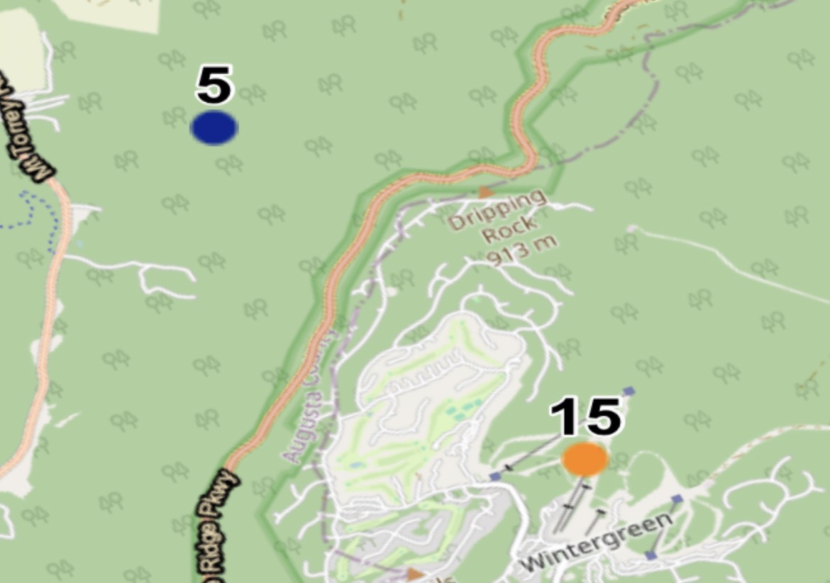
And the central Shenandoah like Bath and Highland and Augusta counties Eta: Is that due to the 500 ull pass just to the south? -
2/26 - Follow-up Hopium Battlezone Storm
WesternFringe replied to DDweatherman's topic in Mid Atlantic
This is true- remember last Tuesday night when most had declared there would be no snow, winter was over, and that the GFS was high? ravensrule and I and like 8 other weenies were the only ones left on the thread! Lol -
Feb 22nd/23rd "There's no way..." Obs Thread
WesternFringe replied to Maestrobjwa's topic in Mid Atlantic
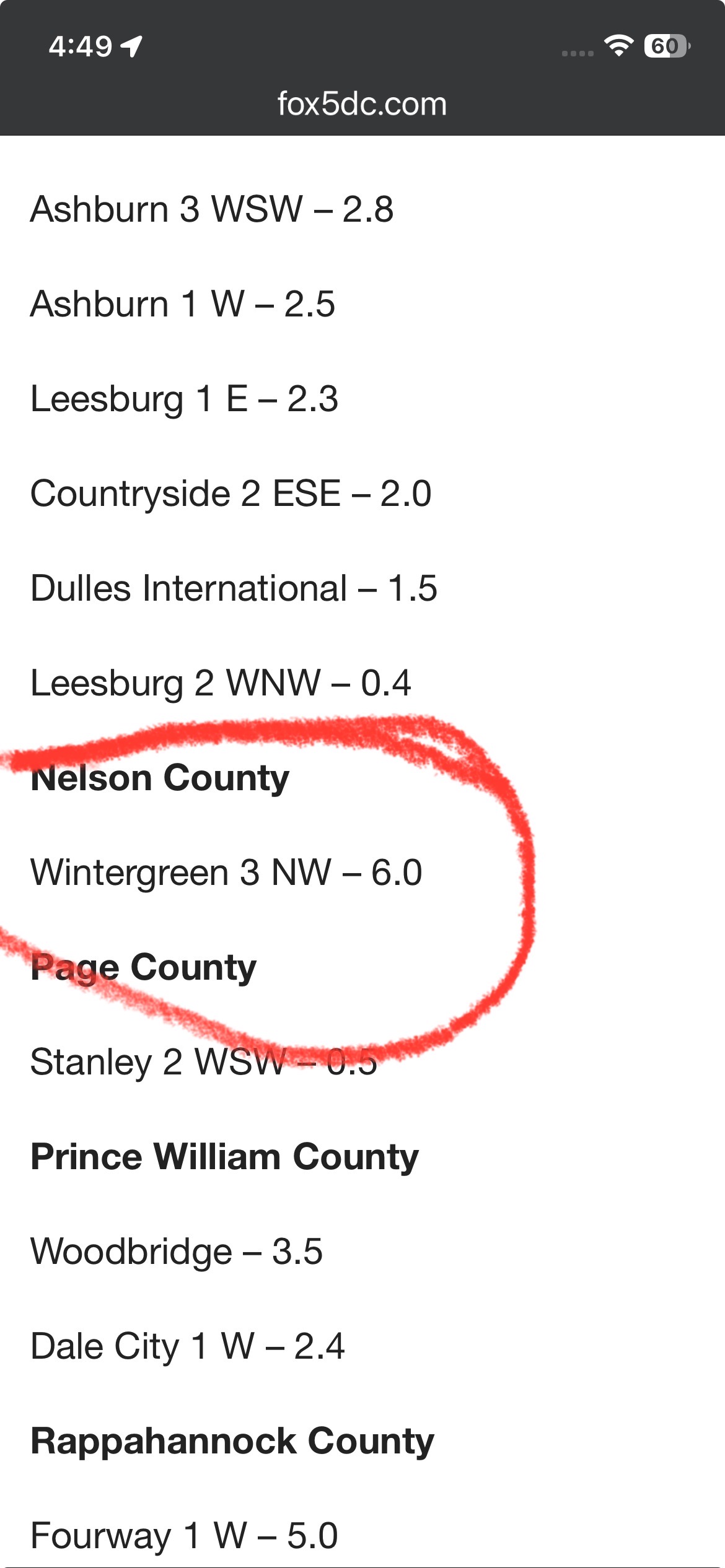
Yeah, I am calling BS on the Wintergreen self report. Up in the northern part of our county (Augusta) had 6” and 5.5” observations by trained spotters up around 4300 ft. I was hiking up near there yesterday and saw it. The other report near Wintergreen around 5” makes a whole lot more sense. Maybe more at the peak at the resort, but 10” more? Not buying that for a minute.
-
Feb 22nd/23rd "There's no way..." Obs Thread
WesternFringe replied to Maestrobjwa's topic in Mid Atlantic
Where did you see that?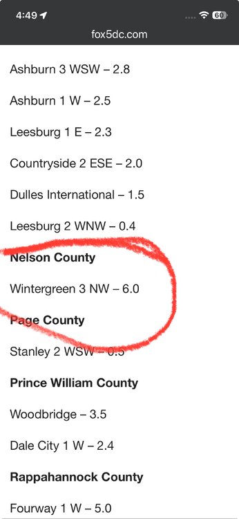
-
Feb 22nd/23rd "There's no way..." Obs Thread
WesternFringe replied to Maestrobjwa's topic in Mid Atlantic
Moderate snow with parachutes and 33 degrees. NW of Staunton in Augusta County. -
Feb 22nd/23rd "There's no way..." Storm Thread
WesternFringe replied to Maestrobjwa's topic in Mid Atlantic
Because people like good trends regardless of the model? -
Late February/Early March 2026 Mid-Long Range
WesternFringe replied to WxUSAF's topic in Mid Atlantic
You just posted 2 sets of maps from different models of 4 consecutive runs showing......trends. -
Late February/Early March 2026 Mid-Long Range
WesternFringe replied to WxUSAF's topic in Mid Atlantic
No, no one does. That is why we are all here tracking the models run to run. If you know how this works out, you should tell us and save us all the time we are investing into tracking. -
Late February/Early March 2026 Mid-Long Range
WesternFringe replied to WxUSAF's topic in Mid Atlantic
So perhaps people calling the time of death on this threat last night was premature? -
Late February/Early March 2026 Mid-Long Range
WesternFringe replied to WxUSAF's topic in Mid Atlantic
I like how everyone now knows for sure what is going to happen on Sunday. Eta- And through the end of the month now, too? -
Late February/Early March 2026 Mid-Long Range
WesternFringe replied to WxUSAF's topic in Mid Atlantic
He has repeatedly said 84-96 hours out, so it matters when the threat is over a given weekend. ETA- So yeah, we usually start getting a good picture by Wednesday. -
Late February/Early March 2026 Mid-Long Range
WesternFringe replied to WxUSAF's topic in Mid Atlantic
Euro had a pretty expansive precip shield for not being able to ‘find the storm.’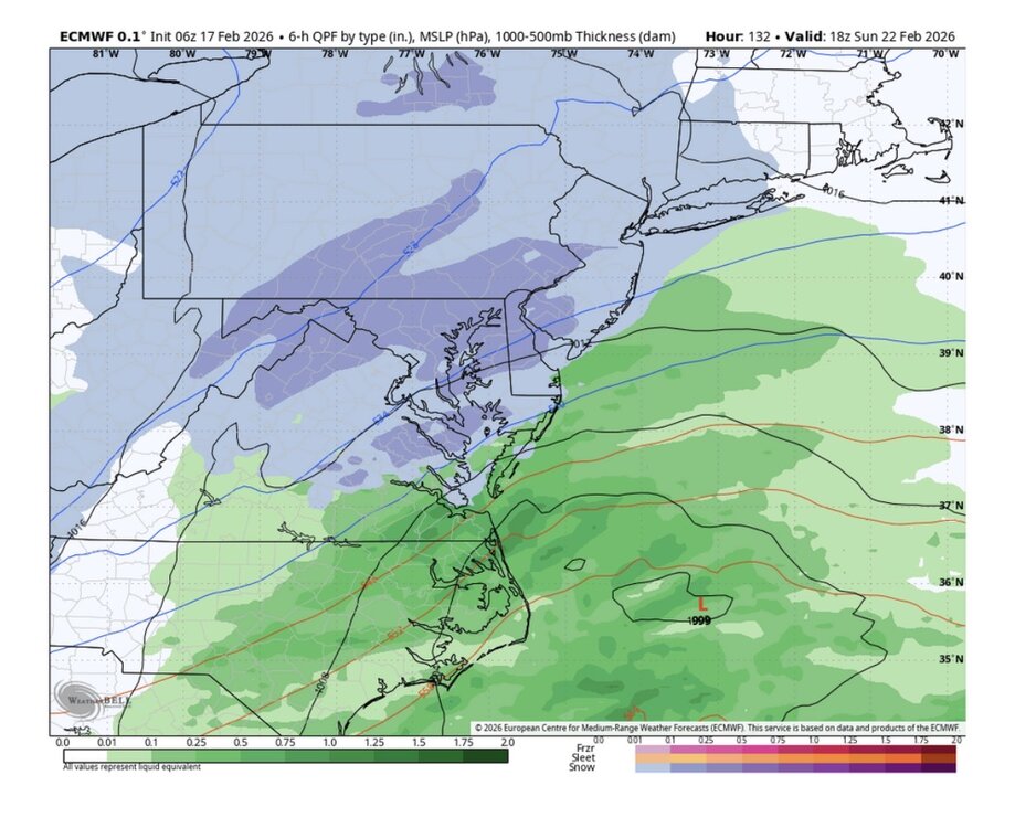
-
Late February/Early March 2026 Mid-Long Range
WesternFringe replied to WxUSAF's topic in Mid Atlantic
Anyone have the kuchie for the Ukie? -
Late February/Early March 2026 Mid-Long Range
WesternFringe replied to WxUSAF's topic in Mid Atlantic
The 6z Euro just gave me 2". -
Late February/Early March 2026 Mid-Long Range
WesternFringe replied to WxUSAF's topic in Mid Atlantic
A winner for whom? You and I get zero snow in Augusta County. -
But he said the CAD was underdone, which would lend credence to the ptype it was showing. Also, the physics based models have all started to say the same thing, lending even more credence to the AI solution.
-
You said it was fools gold but then said the NWS was wrong and the CAD was underdone. But if the CAD was underdone then it gives more credence to the Euro AI solution vs the rainier physics based model solutions. Your two posts together make no sense. Lastly, the Euro AI has the highest verification scores on the planet right now. So your comment about it not being ready for primetime makes no sense to me either.
-
Huh?
-
Couldn’t be worse than this mausoleum lol
-
Had 3 here
-
Uccellini said he would rather be Charlotte for this storm.
-
So it is either suppressed to Georgia or a cutter to NY? Got it!
-
Very light snow and 31° here NW of Staunton in Augusta County.
-
22 degrees and clouding out here in Swoope (Augusta County). Still waiting on snow to start.
-
Same here!