

Greg
-
Posts
2,043 -
Joined
-
Last visited
Content Type
Profiles
Blogs
Forums
American Weather
Media Demo
Store
Gallery
Everything posted by Greg
-
I'm with ya!
-
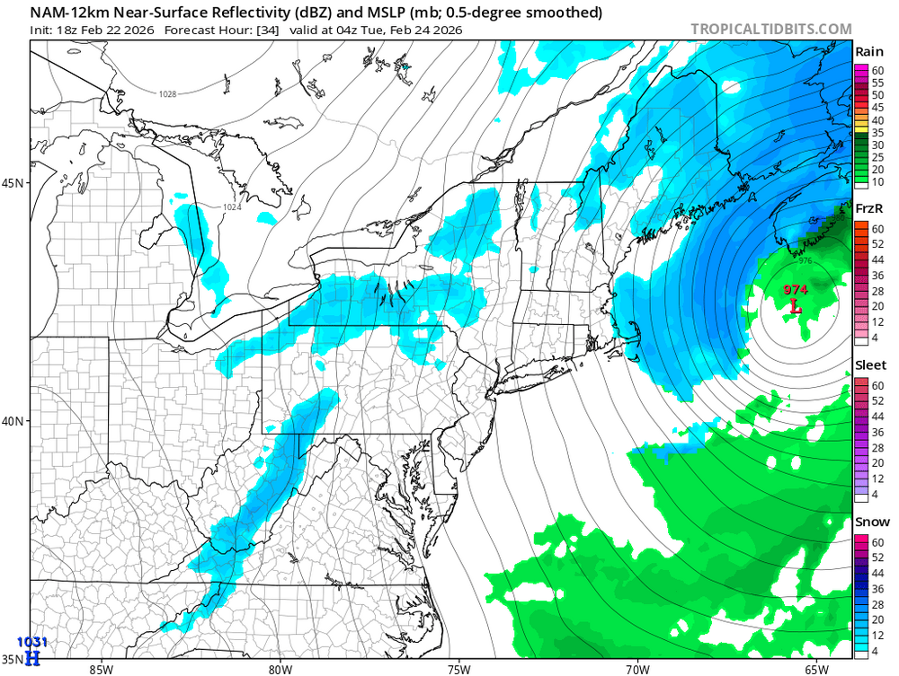
The snow actually stops around 04Z Tue (11PM Monday)
-
Maybe. But if one wants this to stay at or even a little inside the Benchmark, the pressure needs to be slightly lower to stay a little more huggy so heavier preip can get further north.
-
Nam is good but relatively weaker with its central pressure.
-
That makes sense then.
-
Where are you located?
-
That's actually north of Taunton. That's the Mansfield area.
-
Scott is correct it just cuts north
-
I should have said "to Manfield to Brockton." My bad, I made it sound like only that area north. Obviously, not my intention.
-
I knew nothing can keep Jim Cantore from a good, old-fashioned Northeaster. Love it!
-
I think the temps for the upper Cape far Southshore will make the snow too wet and heavy to readily accumulate like that. I still believe that further northwest from Mansfield to Brockton will be it. But where that mega cast band does sets up will be the secondary of course, but where that will be is TBD at this time.
-
And as I stated before they just boosted these up. I believe that Mansfield to Brockton will be the true jacks of this particular storm based upon the latest trajectories now.
-
Yeah, Boston still has you guys in the 12-20" range. Thinking the 20 is the limit there. Highest for the east facing elevations.
-
I think 30" in a one or two areas is more the ceiling for this particular storm overall.
-
The true capture and tug will determine the final track and the where the nowcast banding will truly set up. Also, temperatures will be paramount.
-
Here's the storm forming now.
-
Been pretty dammed steadfast.
-
Don't know if this makes people feel better but the 15Z HRRR still looks good.
-
That is very true that the amount of snowfall is irrelevant, but they just boosted the Boston area into the 18-24" amounts. Converted the Winter Storm Watch to a Winter Weather Advisory for Nantucket. Increased snow totals across east central Massachusetts and Rhode Island to show a widespread 18-24 inches.
-
It appears Boston/Norton put us into that even after seeing the GFS. The only conclusion I can come to is that they believe it a glitch or outlier and the Mesos have a better handle on it. I would love to post their true thinking here on this board to see if this thinking is true.
-
18Z's are usually overamped. Been this way for a long time now. I always adjust the forecast because of this
-
Wouldn't be surprised now.
-
If it is this possibly could be one of the largest busts since March of 2001.
-
I trust the Mesos now vs the longer-range models at this juncture.
-
I think it might be possible for that 20" mark to make it into the Boston area. Not sure but possible. I don't think this will be exclusively just for SE Mass situation.


