

Cobalt
-
Posts
4,865 -
Joined
-
Last visited
Content Type
Profiles
Blogs
Forums
American Weather
Media Demo
Store
Gallery
Posts posted by Cobalt
-
-
2 minutes ago, clskinsfan said:
Look at the Aleutians. Huge difference between a LP and HP there. It sets up the position of the ridge on the west coast. We cannot score consistently with an HP there. That is a cutter pattern almost always.
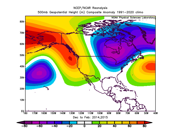
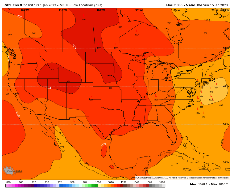
This is true. If anything, it shows how lucky we were in the 13-14 and 14-15 winters. Without the major PNA/EPO help, this isn't far from being a pattern where we're on the wrong side of the gradient (possibly like what we're about to deal with in the D8-14 range):
-
 1
1
-
-
.png.bef28a0310dc6a252c13ca01661f2a55.png)
It's crazy how DCA averaged just 18" during this stretch. Even with the 11-12 and 12-13 duds in there, that's one of the better h5 looks you could expect over such a long average.
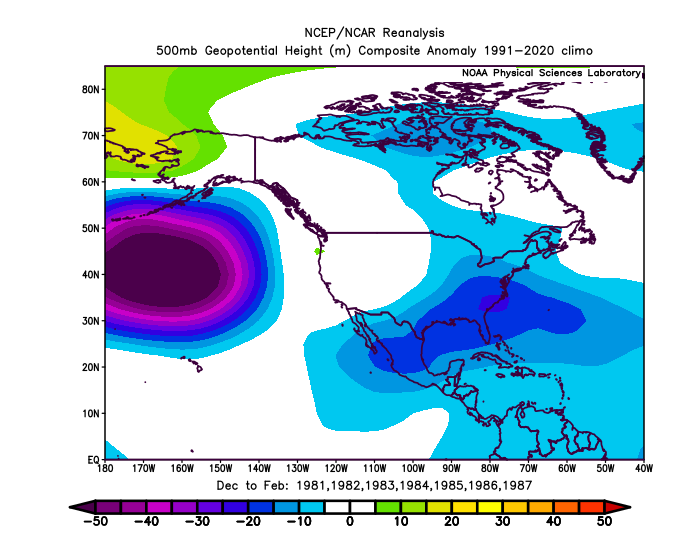
For reference, here's a stretch in the 80s where DCA averaged around 20". Definitely didn't need an insane +PNA/-EPO + cross-polar flow to pull that off. Of course the selected periods end up a bit arbitrary, but this is just meant to show two periods of similar snowiness in separate eras.
-
2 minutes ago, Ji said:8 minutes ago, psuhoffman said:But if speculation the WAR is a result of warming SSTs and if those are permanent umm…
You had 50 inches 2 years ago and Texas froze to death. Winter can still be fierce thankfully
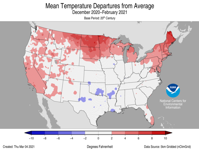
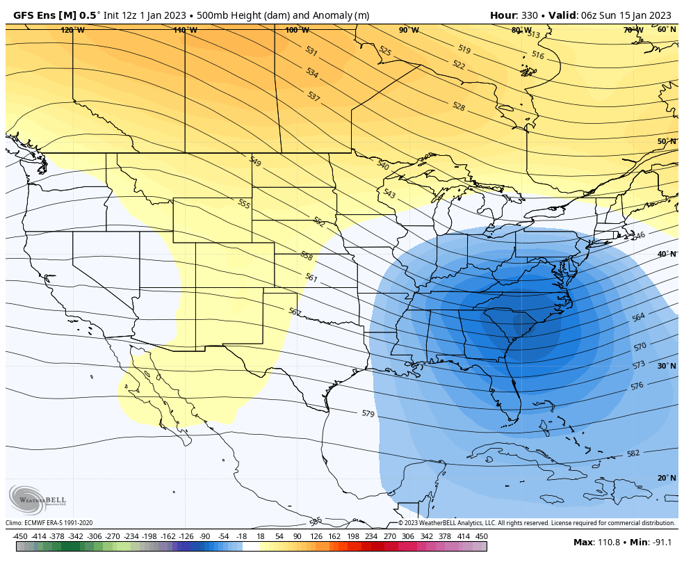
Even in that month (Feb 2021) there was a ridge present off of the East Coast, so despite a -NAO and a part of the TPV entering the country, it was all dumped in the Midwest/Western US.
There's definitely been quite the persistent SE ridge ever since the 2015-16 winter.
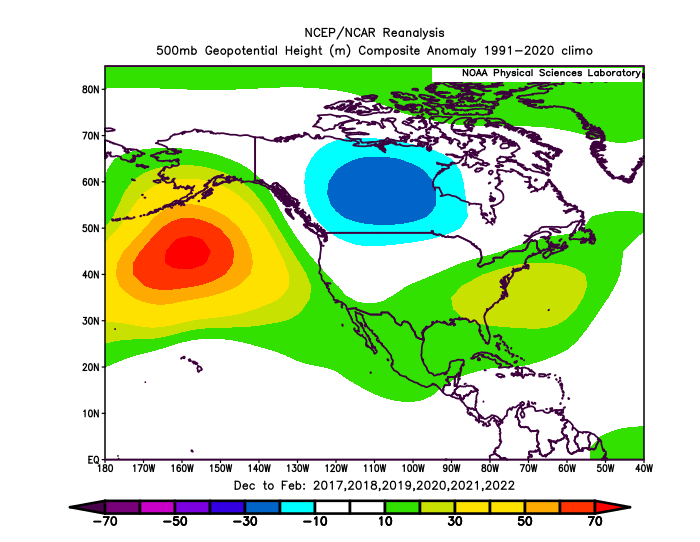
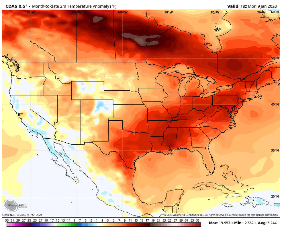
Corresponding temperature anomalies show this as well
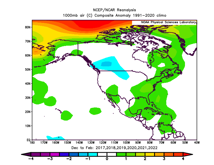
Perhaps it is just a major extreme that will regress closer to the mean in the coming years, or a product of the warm SSTs. A stout favorable El Nino would definitely be a test of which teleconnections are truly running things around here.
-
3
-
-
"Winter is in a bit of a slump" is a funny way for Ji to refer to DCA's least snowy 7 year stretch in its entire history.
-
^ Hard to get substantial snowfall with sustained like warmth like we've seen so far this month. Moderately AN is one thing, but +10-15F seems more akin to November climo.

-
1
-
-
47 minutes ago, Heisy said:
Right in time for Ji vacation

.Would fit remarkably well with what we've seen ever since late Fall, with major -EPO spikes that precede a transient (albeit stout) colder regime in the Midwest/East, taking place every month or so. A similar tanking of the EPO happened close to the 15th back in November, another one near the 18th of December, and now it's plausible that a similar event will take place near the 20th-25th of this month.
-
10
-
-
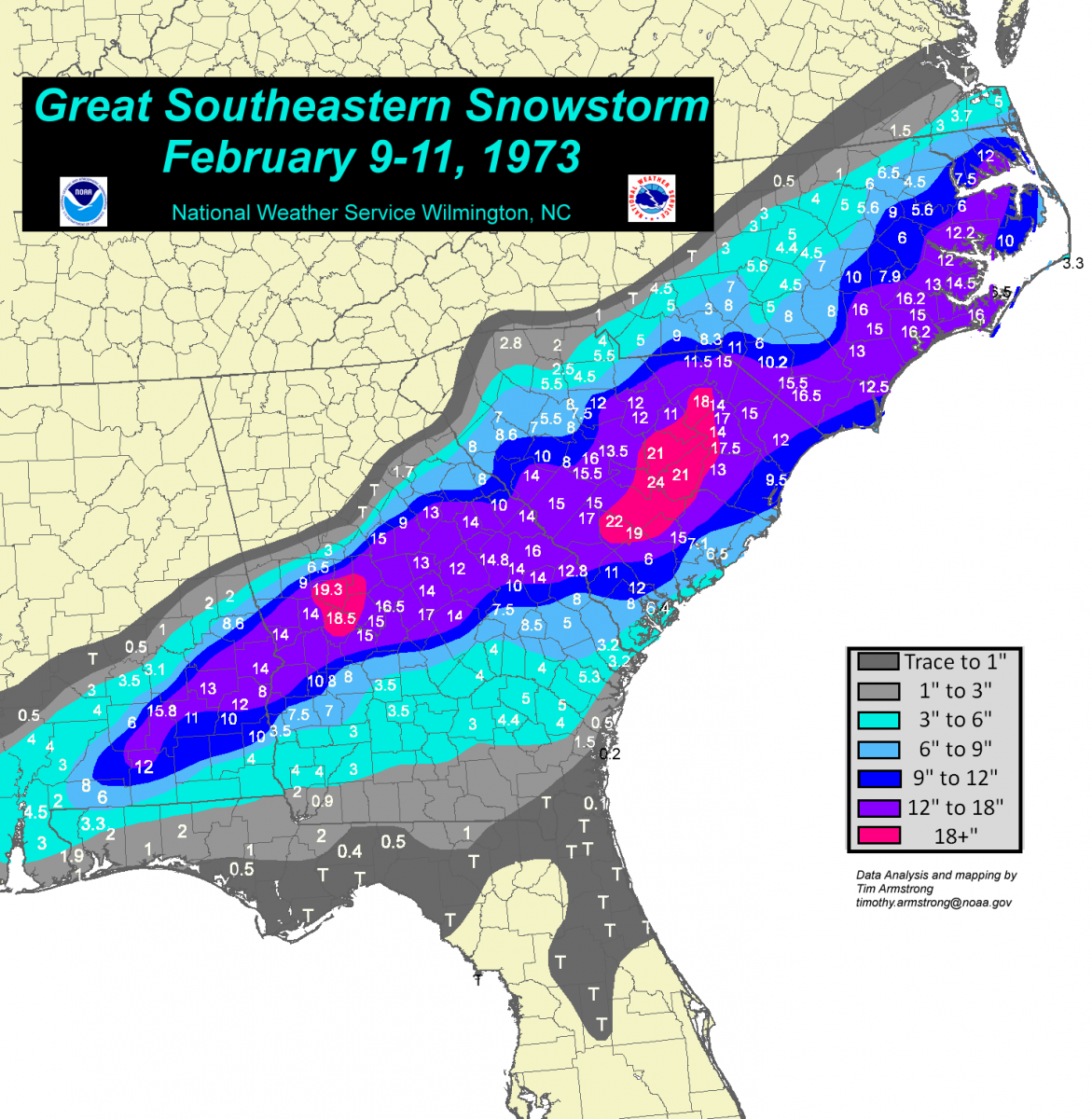
72/73 was an example of a snowless winter that ended up bottoming out at 9F at DCA.. much like this one. That winter might've hurt more though, as it had the infamous Southeast storm in February..
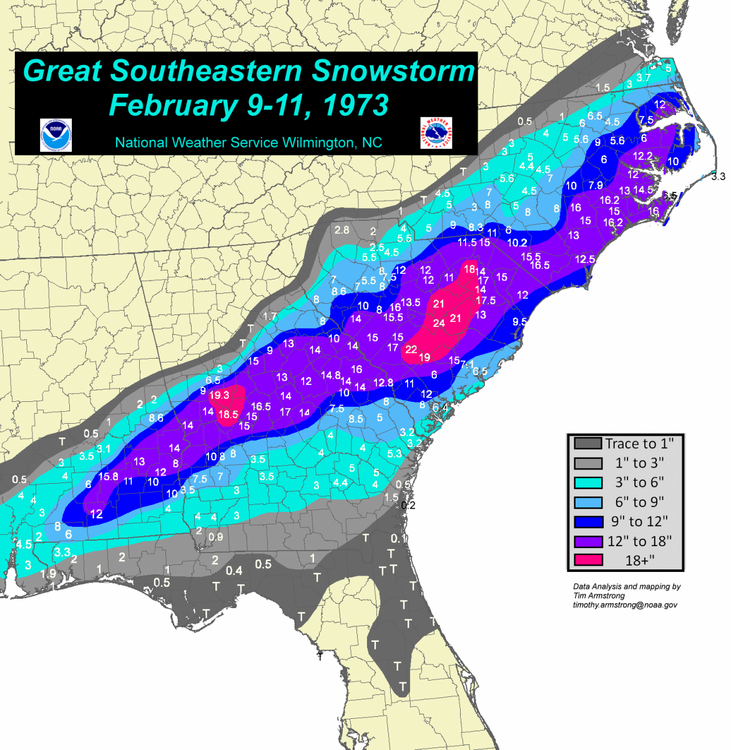
I could not imagine the state of our subforum if something like that took place nowadays.
-
 2
2
-
-
16 minutes ago, psuhoffman said:
Don’t worry. The longwave pattern might look great
but…

Temps still look mostly torched everywhere in N America except the desert SW from constant storms.
Heck of a cold snap taking place on the exact opposite part of the hemisphere.. it's like a Jan 2006 style month in terms of those temp differences. I believe that might've been a similar h500 pattern for us too.
-
18 minutes ago, WesternFringe said:
In the 1970s they were worried about a quickly approaching ice age because of the extreme cold.
This is a common fallacy. Around 10% of peer-reviewed papers discussing the future of our planet's climate in the 70s predicted cooling, meanwhile 62% predicted warming, and 28% had no stance. To be more relevant to this thread, you've mentioned record cold at local sites, but that has been over very short stretches. When just looking at the temperature departures for the past 2 winters across the CONUS, they skew pretty warm.
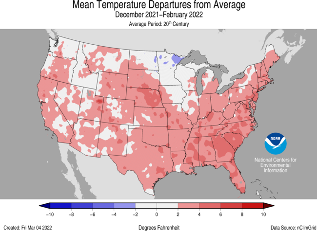
And yes, there were several record cold days or even weeks, notably with February 2021, and a bit less with the chilly January 2022. The issue is that one cold stretch or even month doesn't make a cold winter, and when those major cold patterns haven't aligned, we've defaulted to being much warmer than average.
This is obviously a small sample size but it was mainly meant to go over what you've said about the recent record cold. It's been mostly drowned out by warmer stretches taking up a majority of the rest of the winter, much like we're seeing now. Perhaps things will flip if we sustain a stretch of warmer ENSO years, but expecting cold and snowy seems to only work around 2-3 times per decade.
-
36 minutes ago, psuhoffman said:
PPS... we will still get seasons where the predominant pattern includes both an AK ridge AND an eastern trough so that we get constant injections of cross polar air and snowy years because of it. But those are incredibly rare things and so this is about what our fate is during the majority of the time when that is not the case. And even in those in between years it will still snow some...it's not like we are seeing no snow at all the last 7 years. Last year we got some incredibly unlikely luck with some wave spacing in early Jan and for coastal areas a perfectly timed phase in late January to get snow so I am not saying it won't ever snow...just that it seems to be taking an increasingly unlikely confluence of events to make it happen.
I need to find the graph that demonstrates this, but you could add this to the list of "positives" in the new base state. IIRC we are seeing more extreme -EPO events like Nov and Dec 2022 than we were 20-30+ years ago. As you've mentioned it tends to be a pretty weak signal of snowfall, but in non-nina years (the 13-14 and 14-15s), it can carry an entire AN snowfall season. In the end that would likely just mean that a given decade would have 2-3 PAC driven years, but mitigated by the fact that you'd also be seeing 2-3+ complete duds, with the rest in between (which is basically what we've seen during the past 10 winters). And as you've mentioned, cross-polar flow seems to be losing its bite too, so if we start to fail with even basic cold in those setups.. maybe it's time to find a new hobby in pouring copious amounts of liquid nitrogen into the Pacific ocean.
-
-
The April 18th snow event. I had never seen snow fall that late into the season before, so watching 2-3" of snow pile up during the daytime in mid-April was just incredible.. definitely not used to seeing that late of an event back home.
-
1
-
-
14 minutes ago, Chris78 said:
I don't think it's what we wanted. It definitely moved towards the euro and cmc with dampening out the lead wave and Amping up the next one by the time cold air is moving out.
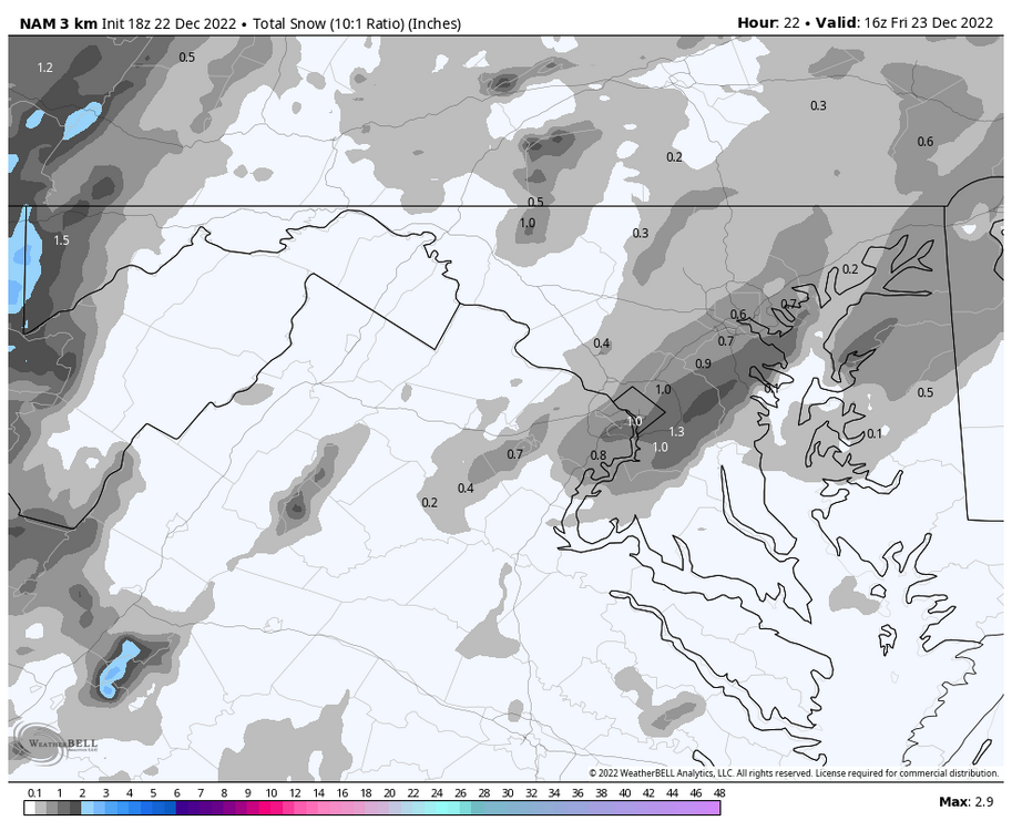
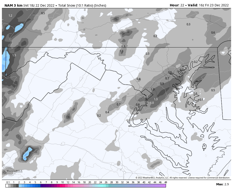
Verbatim the GFS has ~.2-.3" QPF falling over the course of 12 hours (mostly overnight) with temps in the mid 30s. As shown that could provide the first flakes/coating for most of the central subforum area, but as you said it seems to be trending weaker as that second wave comes in stronger and much too late.
-
2 minutes ago, psuhoffman said:
That’s the bar now? Rooting for a repeat of 2002. Lol
Only because of what happened the following year.. Gotta play the long game

-
1
-
-
52 minutes ago, psuhoffman said:
So explain to me what longwave pattern works in that background state, when even in the old “normal” we needed solidly negative anomalies to snow.
Attempting to "reshuffle" patterns nowadays just feels like rearranging the deck chairs on the Titanic.
-
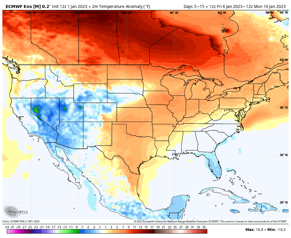
EPS also has an intriguing look out at Day 14. Takeaway is that all 3 of the major ensembles look to mix things up as we enter the D10-15 period.
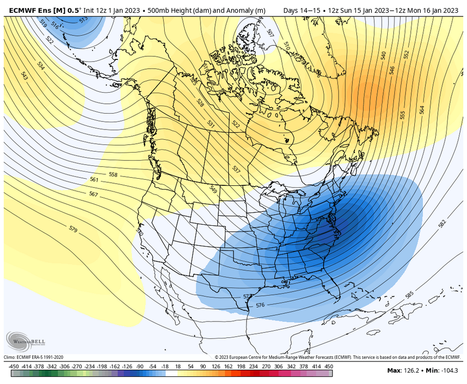
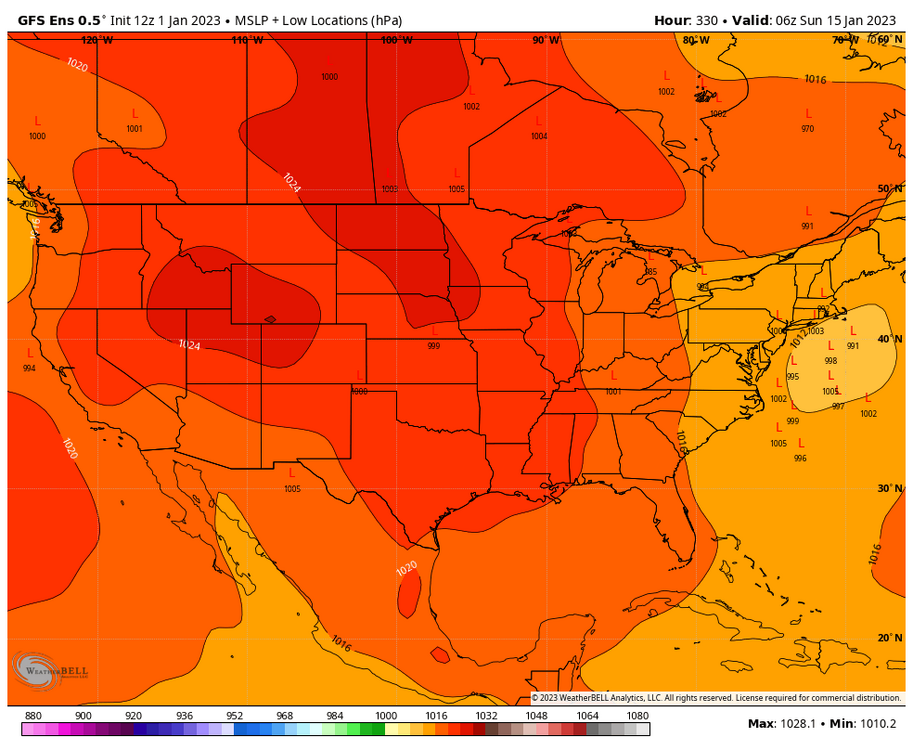
EPS also moderates temperatures quite well, so after an anomalously warm start to the month, the ensemble mean has the following 10 days closer to +1-3F which isn't all too warm during peak cold climo. The temp distribution with +10-15F across much of Canada definitely reminds me of Jan 2021.

-
2
-
-
Pretty surprising to have this substantial of a signal out at D14 for a coastal, as depicted by the GEFS. In the short term, I think our issue with the 6-10th threats simply hinges on how long it will take to flush out the PAC puke, and I can remember a similar thing happening 2 years ago (Jan 1-15th 2021), where it took weeks for things to become less marginal in the East after a longstanding Alaskan low. Hopefully the further we distance ourselves from the recent influx of Pacific air, the more favorable things will become (before the inevitable Feb -PNA fest)

-
3
-
-
1 hour ago, psuhoffman said:
@Maestrobjwa DC snowfall in non Nino years where Manchester MD had similarly to this year virtually no snow through New Years.
3.4”, 4.9”, 2.2”, 4.5”, 10.3”, 3.2”, 3.4”, 0.6”How did you fare early last winter? IIRC DCA had no snowfall whatsoever until January 3rd, with 13.2" falling through the west of the winter. I don't recall there being any events for the Northern parts of the subforum during November or December.
-
Looks like DCA topped out at 22F which would be the coldest maximum temperature for December 24th since records began, narrowly beating out 1989 (23F). The daily average of 15.5F (22/9) also beats 12/24/89's average of 16.5F (23/10), making this the coldest December 24th on record for Washington D.C.
-
4
-
-
22 minutes ago, psuhoffman said:
THIS THIS THIS THIS THIS... we've wasted several blocking periods over the last 5 years because there was still mid latitude ridging despite high latitude blocking.
If North Atlantic/Gulf of Mexico SSTs are to blame for our blocking periods not working out then that would make perfect sense. Our 2 arguably most productive blocking periods during this stretch were Feb 2021 and March 2018, late enough in the season that the Atlantic and the Gulf at least had some chance to cool down. These blocking episodes in December or into January don't work the same as they used to, and that definitely fragments the winter season.
-
2
-
-
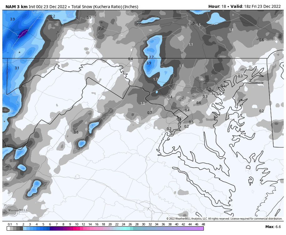
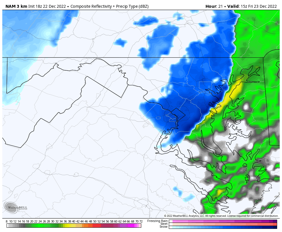
The 0z 3k NAM has its best depiction of the snow associated with the front. Shifted a bit North, but definitely a swath of 1"+ that wasn't as prominent in previous runs.
-
5
-
-
3 minutes ago, nj2va said:
Heyoooo! Tomorrow morning should be fun.
Our epic pattern might be condensed into 5 minutes of +SN tomorrow, but that's all we could ask for given this past week of trends. An old fashioned snow squall would definitely help brighten the mood, the 18/19 and 14/15 winters had some great ones from what I can remember.
-
4
-
-
3k NAM does suggest that there might be a brief period of snowfall associated with the front.

-
5
-
-
33 minutes ago, MN Transplant said:
It looks like the HRRR is running 4-5 degrees colder than the other models, so 10 is a better forecast. Still, a pretty good situation to get DCA low since we aren’t counting on radiational cooling.
My lowest December temp since getting my station in 2011 is 13. Should have no trouble beating that.
Yeah the HRRR is definitely running a bit too cold, but I'm personally interested in DCA's high temp on the 24th. The 3k NAM has the site topping out at just 19F, which would be an extremely cold day for December standards. That would be just the 4th time at the DCA that the high temp failed to get out of the teens during month of December. 12/22/89 (17F), 12/25/83 (14F), and 12/31/62 (18F) are the only other times that's happened at the airport site. If we can't do snow, then at least the cold snap will be something of interest. That said, I greatly appreciate all of the snow reports and pics coming from the western part of the subforum

-
1
-


The Seasonal Snowfall Futility Markers
in Mid Atlantic
Posted
Just curious, what was the latest other winter that this one has now surpassed? I'm honestly surprised that 15/16 produced that early at your location as well.