snowmagnet
-
Posts
962 -
Joined
-
Last visited
Content Type
Profiles
Blogs
Forums
American Weather
Media Demo
Store
Gallery
Posts posted by snowmagnet
-
-
4 minutes ago, losetoa6 said:
6z FTW

Nice! Another post-60 degree storm?
-
8 minutes ago, WinterWxLuvr said:
My feeling is changes galore regarding day 6-10 are coming. 10 days from now we might be saying damn that was fun. Lots of potential. Hope nothing shows up on a model outside of 48 hours.
This is what we need in here. Thanks for the optimism!
-
 3
3
-
-
7 minutes ago, Ji said:1 hour ago, Weather Will said:WB 12Z EURO…week for improvement….


It has a better chance of getting worse than improving
Where is the panic room when we need it for those of you who have empty glasses?
There is plenty of time for positive trends this week.
-
3 hours ago, southmdwatcher said:
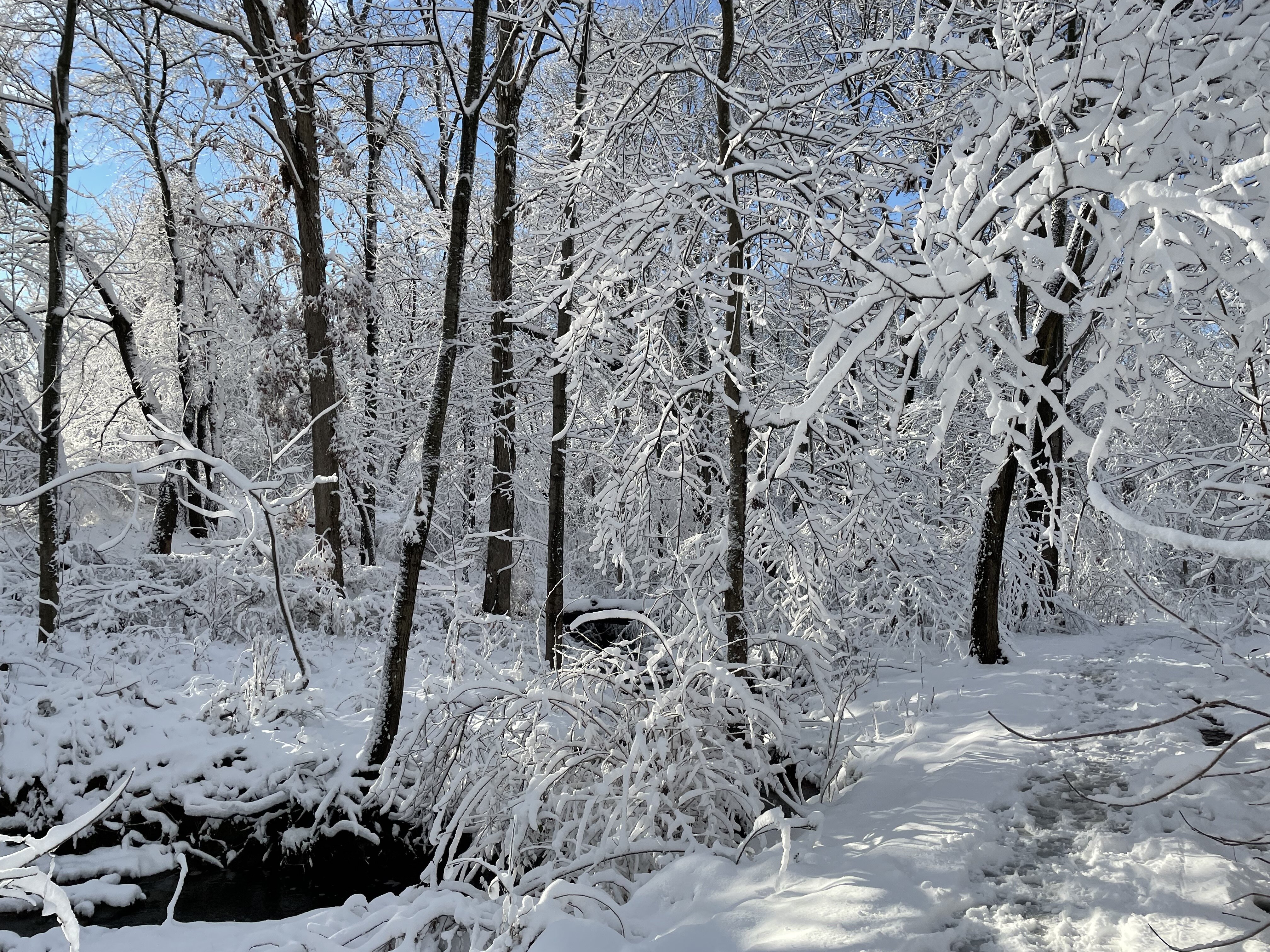
January 25 2000, was the ultimate surprise event aside from the shock of PD1's extreme snowfall. March 1993 wasn't a severe snowstorm, but I was in Richmond Virginia for an event. I got to witness the low center pass directly overhead. The heavy snow(6 inches) of the overnight turned into heavy wind driven rain and temps in the mid 40's. The rain stopped and the winds calmed as the sky brightened and then temperatures crashed to the upper 10's in a two or three hour period with a flash freeze and wraparound snow accumulating several inches.
January and February 1996 was the best year for overall snowfall in southern Maryland, even eclipsing the very special 2009-2010 season. 1994 had all those icing events.
Hands down the best event of my lifetime is PD1. It was the first major snowfall for me. Could barely see the house across the street through the extreme rates and wind. The car engines ended up snowpacked under the hood from the blowing and drifting. Vehicles were practically buried in drifts as the snow ended. Large drifts up to 2nd story windows in southern Maryland and no school for a week as everyone had to help out in digging our street in St. Charles. Never before or since have we had an issue with not getting plowed in each large snowfall within 24 hours.
I grew up in St. Charles too - Garner Ave. I was a kid during PD 1, but I’m pretty sure that began my love of snow. I have definite memories of ‘79, ‘83, and the Veterans Day surprise of ‘87. I always loved when we got more snow than Fairfax (unusual, but it would happen as it has this year!) I’ve lived in Fairfax now for 26 years.
I was pregnant with my daughter during PD 2. It was a welcome week off because I was pretty sick that week. 2009-2010 was definitely my favorite year for snow. I was tracking it and got to have a blast with my kids and my dog. I think my profile pic is from Snowmageddon.
-
2
-
-
I was wondering about that special weather statement. Is the NAM freezing drizzle only for east of town?
-
I love drastic temperature drops, especially during summer thunderstorms. My best memory of a drastic temperature drop is going in to a Caps game years ago in a very warm rainstorm and walking out of the game looking for our car in several inches of snow. The snow was not predicted as far as I know. I think it was probably around ‘97 or ‘98.
-
4
-
-
1 hour ago, clskinsfan said:
We got screwed early in the season last year with the cold air getting trapped on the other side of the hemisphere. We have had plenty of cold this year. It just so happens east did better. It happens. Doesnt make it any less insufferable for those of us to the west. It just is what it is.
I get the frustration, especially when the western zones should be getting more snow than those of us further east. Last year, those of us east of Loudoun had a terrible year, (but better than 2020), so this one has been fairly decent. It would be nice if all of us can get in on a storm. It’s been a while.
-
2
-
-
1 hour ago, psuhoffman said:
Maybe this belongs in the "climo" thread more and if so Mods can move it. But I wanted to point out something regarding what we are struggling with. Since this pattern set in early January we have been cold enough for snow about 90% of the time. Yet 90% of our precipitation has fallen during the 10% we weren't. That isn't just bad luck. That is the most likely outcome at our latitude (south of the mean latitude to support snow) in any pattern without blocking. The current favorable Pac bad Atlantic pattern is better then a no hope shut out the lights pattern we often get if the pac is bad or both are bad. Historically we could overcome a bad pac with a good atlantic sometimes but lately with the PAC on fire and the base state warmer it seems when the pac is bad it just torches the whole continent and the NAO can't save us. So realistically to get a really high probability snowy pattern we need BOTH to cooperate. Still a good pac isnt awful and it will put us in the game and eventually we might get lucky on some waves...but wanted to explain why we need luck. For most this is nothing you don't already know but we have some new posters.
I am going to really really really simplify this. And for those that know more yes its possible to get a storm on the back side of a trough in a NW flow with upper level driven energy and vorticity or with localized WAA along a NW to SE oriented front. But those aren't the typical way we score so lets just make this simple here.
Most storms are going to lift the thermal boundary north. As they amplify they will pump ridging ahead of them from the southerly flow. The cold boundary will lift with it north. If we don't have anything to resist this...we are too far south to end up on the cold side unless we get extremely lucky and a wave tracks just southeast of us out of pure chance.
With blocking that is not the case. I am using Feb 2010 to illustrate this point.

Look at the pacific. This would be absolutely awful without blocking. The mean flow into the central US is all from the SW. But we have that huge block with a northerly flow locked into the northeast so we actually want that southwest flow to our west to take the STJ and throw it up into the cold. Now look at the actual storm track.
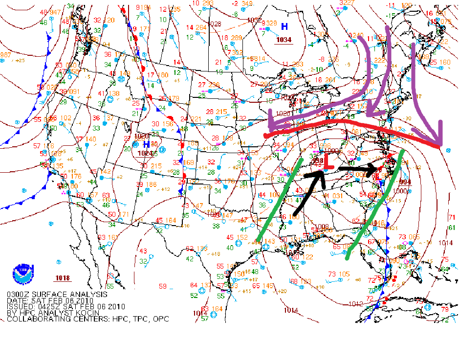
The primary for the 2010 storm was cutting to Ohio. But it ran into the blocked flow and was forced to turn east, develop a secondary, and slide east and out under us. Because of the block we had a HUGE window to win. ANy storm that tried to track anywhere between those green lines was going to end good for us because of the block. Nothing could cut so it would have to turn east under us.
Right now we have a great pacific pattern putting a trough in the east. But without a block we have to get that trough to align absolutely perfectly to get a system to track just southeast of us by pure chance. There is nothing to "block" a storm from cutting west. So basically below is our current "win" box. We have to get a storm to accidentally track within that tiny red box.

Again, its not impossible. We do get plenty of our snow from these patterns by luck without blocking...and if we get enough chances eventually we should get lucky...but I do think the big winters of 2014 and 2015 which I've said were probably flukes and not indicative of a typical outcome from pac driven no blocking patterns, skewed some wrt what to expect. This pattern is way way better than if the pac was a mess like most of the last 5 years. If we arent going to have a -NAO this at least puts us in the game. But it's a really frustrating pattern in that it is cold and you think it should snow...but we have to get the storm track to be absolutely perfect for it to actually happen.
This is really useful for those of us who have never read college meteorology books for fun. I knew that the PAC had been horrific for several years, but I thought we were supposed to get a favorable Atlantic at some point. Hoping for a random block.
I appreciate the explanation of Feb 2010 -it was such an amazing month. My Facebook memories started popping up today. I didn’t remember that we got several inches a few days before the Feb 6th storm.
-
43 minutes ago, psuhoffman said:
For this region in general our snowiest period is Dec 1-March 15. About 1/3 of our annual mean snowfall is from Feb 15-March 15. Yet some people want to throw that away every single year. WTF
Thank you. I never understand the pessimism by early February. We had quite a lot of it in here during January too. Some years we get our biggest snows in March.
-
2
-
-
3 minutes ago, Yeoman said:
So you have access to real time models and discussions on this site but you go to WTOP for your forecasts?
No. I don’t even listen to the TV Mets anymore. I just happened to hear it in the car on the radio and wondered where that came from!
-
I kinda like this warmish afternoon. 46 in Fairfax. Not looking forward to warm rain turning to cold rain.
-
1
-
-
I just heard on WTOP that Friday will feature rain changing to sleet and snow during the day. Did I miss something?
-
1 hour ago, WxUSAF said:
Do it
I started a February long range thread. can someone pin it?
-
I’ve never started a thread, but hopefully my name will bring us some luck. Phil said winter isn’t finished, so let’s keep Stormtracker busy with the pbp’s this month.
-
I’ve never heard of this storm and I’m surprised my parents had never mentioned it. They were both living/working in DC at the time. How is this not in the top 10 storms of DC? I know the DC has a snow hole, but the cutoff couldn’t have been that different if people were experiencing this in Silver Spring!
-
It’s February 2nd and Phil saw his shadow, so we have more winter to go. Can we start a new thread now? This one is 140 pages and January is over.
-
12 minutes ago, BristowWx said:
I understand this now. this is a loop of the past 5 euro runs. It has trended from a nothing burger to a triple with cheese. interesting to see it like that
Thanks for picking that up. I didn’t realize that was what it was showing. It does seem the Euro is trending more frozen.
-
S
1 minute ago, SomeguyfromTakomaPark said:Yesterday's 12z run had DC at 58 degrees 7am Friday, today's 12z has DC at 35 degrees 7am Friday.
Trending to the GFS?
-
1 minute ago, stormtracker said:

That works too, but we don’t usually get that lucky!
-
I’m happy to accept a 33 degree rain on Friday if we can get the Coastal storm to end the weekend.
-
26 minutes ago, Weather Will said:
WB 12Z GFS Sunday storm

This showed up last week on January 27th. I got a screen shot of it and sent it to my boss - a snowstorm would be her birthday gift. Hope the GFS has this one right.
-
 3
3
-
-
1 minute ago, SnowenOutThere said:
I like the weekend storm on the GFS

Love this!
-
3 minutes ago, Imgoinhungry said:
What is record for most freezing rain in dc metro?
You should probably look at Jan ‘94. Not sure if that was a record amount, but the cold freeze afterwards was brutal and the ice stayed a long time.
-
3
-
 1
1
-
-
I saw that the NWS discussion now mentions the cold front and chance for a changeover Friday morning. It seems that they are hesitant to go there after the last anafrontal debacle. They also mentioned a coastal low possibility on Sunday…
-
1
-


February Medium/Long Range Discussion
in Mid Atlantic
Posted
Then I think it’s been over about 100 times this winter.