greendave
-
Posts
85 -
Joined
-
Last visited
Content Type
Profiles
Blogs
Forums
American Weather
Media Demo
Store
Gallery
Everything posted by greendave
-
light flurries in Burlington the last 10mins. On top of a light dusting that fell overnight.
-
January 30th- Feb 1st ULL and coastal storm obs
greendave replied to JoshM's topic in Southeastern States
Receipts? -
Tell 'em what you want 'em to hear... The next headline on WRAL... "Surprise mid-week storm could produce more snow than last weekend's historic storm for some"
-
January 30th- Feb 1st ULL and coastal storm obs
greendave replied to JoshM's topic in Southeastern States
I figured that had to be the case. To pick it apart further - I can see where "maybe" there's a slim chance its happened for all 100 before - but would include IP and FZRA/ZR. That being said - this has to be the first time ever for all 100 to verify WSW for all Snow. Has to be. Right? -
The “I bring the mojo” Jan 30-Feb 1 potential winter storm
greendave replied to lilj4425's topic in Southeastern States
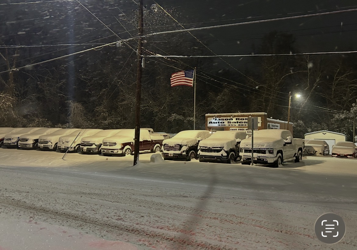
Burlington 12:01am 2/1/26. 24hrs of snow ~7” total. Finally subsided around 1am. Heaviest precip 2-8pm.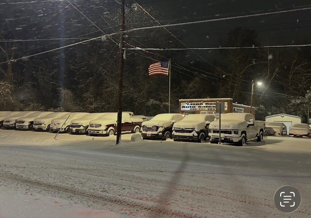
-
The “I bring the mojo” Jan 30-Feb 1 potential winter storm
greendave replied to lilj4425's topic in Southeastern States
I’m making this post after not looking at anything since around 9am. I hate it for WakeCo peeps. with that out of the way. Climatology and geography always wins. Aside from high altitude, high latitude, and lake effect zones. I’ll continue to stand by that Alamance county is the absolute most perfect geographic location for snow anywhere in the US, and anywhere in the world, yes the world, in terms of a CAD environment. models sucked for the most part - esp most short range. It’s been snowing nonstop since 11:30 pm last night but was so light that at 10:30 am we had a mere 0.75” of accumulation and extreme doubt and disappointment settled in but I made a post about peeking returns coming up through Randolph county…then it happened. 1pm hit and it has dumped ever since. Not the most accumulation for the storm, but I’d garner a guess of 6-7” and still dumping. I’ve been outside enjoying and cooking (ribs and chix) on the smoker ever since. For here the storm exceeded the most last minute expectations. I need to review but kudos to the GFS mostly, 2ndly the Euro. And as far as I can tell the ICON and RDPS for crushing the NAM and HRRR. Pure joy from mby in Burlington. Can’t do this again anytime soon, looks like that may be unavoidable. Cant wait to dig in to the post-storm analysis on this one. It’s been agonizing. -
The “I bring the mojo” Jan 30-Feb 1 potential winter storm
greendave replied to lilj4425's topic in Southeastern States
Per previous discussions fair to say we’re likely 2 miles apart. Not a great sample size but thus far you have 1.5” I have 0.75”. I think you could literally split Alamance co in half - hwy 49 and up union ridge rd they 62 is the line. Per that latest mess discussion. I keep hope. That being said wouldn’t want to be in Mebane right now. -
January 30th- Feb 1st ULL and coastal storm obs
greendave replied to JoshM's topic in Southeastern States
Watching those returns like a hawk. Could be a hunch but if those survive through to mby (Burlington/Alamance co) then I feel a lot better about avoiding the dry slot here. It’s gonna be close. fwiw. Noticed light snow around 11:30pm, few hours of sleep and woke up to light snow around 4:30 and going now. Very little (dusting) accumulation thus far. -
The “I bring the mojo” Jan 30-Feb 1 potential winter storm
greendave replied to lilj4425's topic in Southeastern States
The Fish says less worry on the crazy dry slot models earlier - now correcting. 4-7” general thought for triangle with the heavier band somewhere south and east. Don’t be surprised to not see decent precip til late afternoon. https://www.facebook.com/share/v/1DMYr6RKhB/?mibextid=wwXIfr -
The “I bring the mojo” Jan 30-Feb 1 potential winter storm
greendave replied to lilj4425's topic in Southeastern States
Sundown: GFS [Maverick NAM suddenly flies off after refusing an easy shot on Jester Euro] Hey, where the hell are you going? Maverick HRRR: Uh... It's not good. It doesn't look good. Sundown NWS: What do you mean, "it doesn't look good"? It doesn't get to look any better than that. I just can't with this storm anymore... -
The “I bring the mojo” Jan 30-Feb 1 potential winter storm
greendave replied to lilj4425's topic in Southeastern States
we wait.
-
The “I bring the mojo” Jan 30-Feb 1 potential winter storm
greendave replied to lilj4425's topic in Southeastern States
47.9" in Delmarva?!?! Book it! -
Southern Crippler - Get well soon Jimbo Storm Obs
greendave replied to BooneWX's topic in Southeastern States
That explains it. Fascinating.
-
Southern Crippler - Get well soon Jimbo Storm Obs
greendave replied to BooneWX's topic in Southeastern States
Make of it what you will. Burlington,NC chain of events thus far… 7pm extremely light snow. 8pm light sleet. 9-11pm very light frz rain/sleet 11:30pm (with a noticeably heavier radar return) snow/sleet mix Doesn’t make sense with warm nose building/thickening at a rapid rate but perhaps heavier returns will push us more towards sleet overnight and not all frz rain as is currently feared? frankly I don’t know what I’ll wake up to. This storm. The nerve. -
Southern Crippler - Get well soon Jimbo Storm Obs
greendave replied to BooneWX's topic in Southeastern States
Shocked to say we have snow in Burlington (1mi ESE of Elon) -
-
More importantly - another 24hrs of agony…wonder….hope?
-
has this been validated? Their FB last post is the 4pm briefing....something smells fishy...
-
Its all your fault...
-
....cause we have a 4 year surplus stockpile.....and we've been bored....
-
April Fools anyone?
-
Beauty is in the eye of the beholder. This winter - the story of the haves and have nots. IMBY - we had storms to track, but ultimately still below average snowfall for the year. In a year where New Orleans, Florida panhandle, CharlestonSC, grand strand and tidewater VA out performed us, its a tough pill to swallow when several "big dogs" were possible, but never came to fruition. In general I acknowledge the "southeastern states" region - probably a solid B+ but that is very sporadic/inconsistent. For me personally, given the extremely high potential of multiple events, but with ultimately low results I give this winter a C-/D+. That being said, I've accepted the fact, applied first dose of Prodiamine before yesterday's storms, the bass will soon be moving up to spawn, and maybe - just maybe (weather related) the morels will give a good flush this year.
-
February 19-20 Major Winter Storm Threat
greendave replied to NorthHillsWx's topic in Southeastern States
This is undoubtedly the best thing that has ever occurred on these forums. Period. -
Feb 2014 had back-to-back storms that I'd argue gave moderate tree damage in the CAD favored areas b/t Triad and Triangle. I know in Burlington - we had a 4-day power outage with the first storm if memory serves me. Noted - Wake and immediate areas avoided these.
-
Fwiw- interesting microclimate observation. made a trip to Greensboro this am - in the vicinity of US70 & Huffine Mill Rd. There was a noticeable amount of ice in the tops of the trees just north of US70. Nothing on surface and did not notice ice anywhere else b/t west side of GSO and Burlington. Back home and noticing that small little area is roughly 40-100’ higher elevation than anywhere else in the immediate area. Cool!