SnowDawg
-
Posts
1,253 -
Joined
-
Last visited
Content Type
Profiles
Blogs
Forums
American Weather
Media Demo
Store
Gallery
Everything posted by SnowDawg
-
Couple days of trends like that and we are sitting really good. That could be a lot to ask for though.
-
Structurally things looked improved but the 850mb winds were screaming even harder out of the south there so stronger warm nose despite the south/weaker jump.
-
I don't even care about snow anymore. I am the biggest sleet fan ever right now lol
-
Yep, the changes early in runs have been positive at 12z and now starting into 18z. They are small, but small changes upstream can lead to larger ones downstream. No different than the changes leading to the sudden flip we saw last night. Just need these trends to actually continue, not just windshield wiper back and forth.
-
As of now yes. Could easily see things trend towards predominantly sleet but gotta prepare for the worst.
-
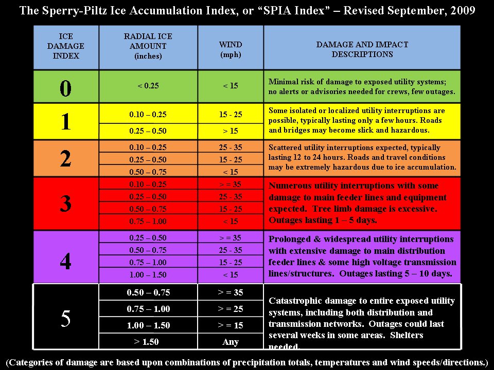
Feels like a good time to share this with the type of ice accumulation being talked about. Unfortunately winds look to get quite gusty during the height of the freezing rain as well. I'm praying for as much sleet as possible now, or for this thing to just cut all the way to Memphis.
-
I hope local communities are starting to get very serious about setting up shelters. This kind of ice with those kind of temps afterwards is a deadly combination.
-
I got 1.6" snow .95 freezing rain Sleet predominant or mixed 10 AM to 11 PM Saturday. Wind gusts low 20s at height of freezing rain.... Would be a catastrophe if that comes to pass. Actually terrified of the 100'+ oak trees around my house in this instance.
-
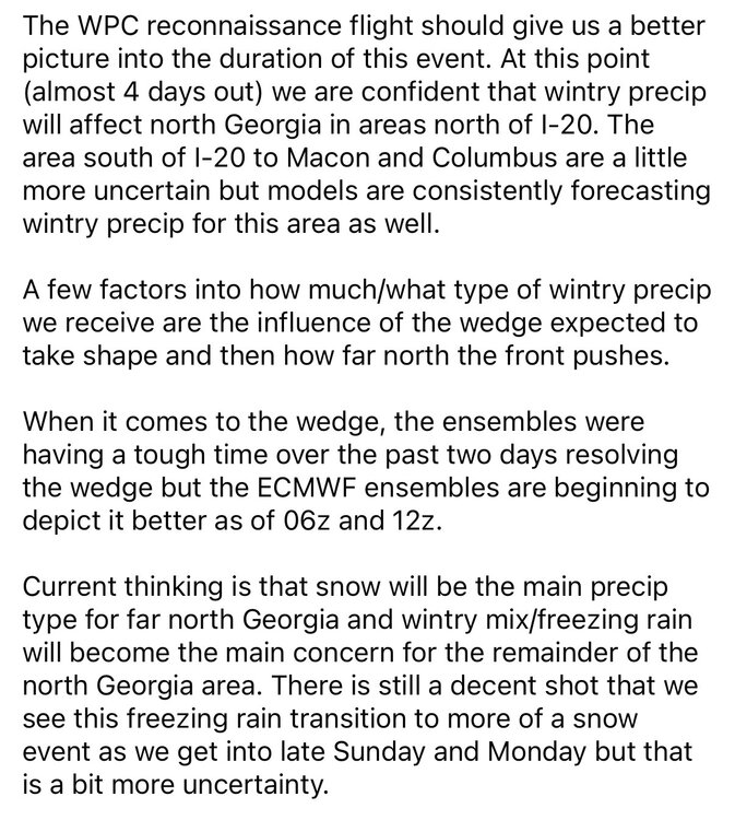
I don't wanna hear that it was just hype from youtube/social media weather accounts either. This was messaging from NWS Atlanta last night. Even going so far as saying they could see more snow being forecast as time went on.
-
Absolute last thing anyone in this region needs to go through after going through Helene....Just an absolute screw you from the atmosphere to us if we can't get this to turn into a sleet fest.
-
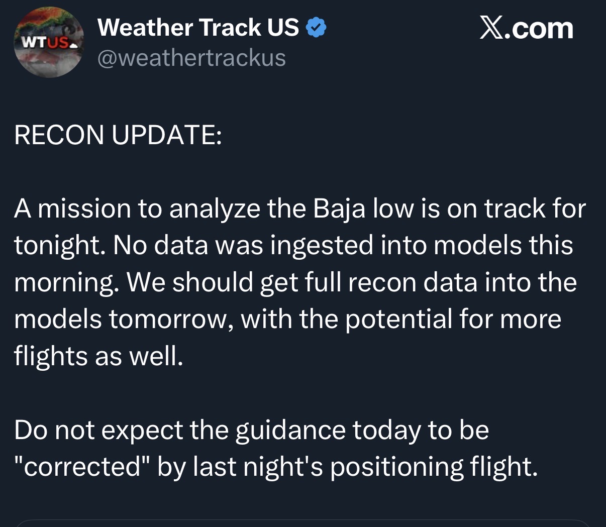
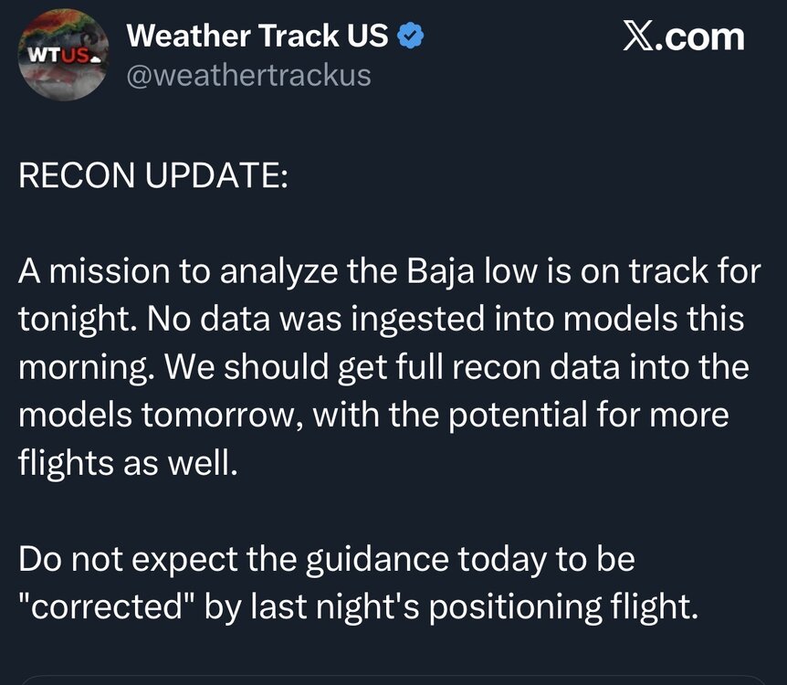
No recon data impacts in the models til tomorrow at the earliest. First data collecting flight is tonight.
-
All three key pieces incrementally improved on the Euro, so I'd expect the result to be slightly improved. We need this to be the start of a trend that baby steps right up til go time.
-
Everything trending towards more ZR is just awful. I'd do anything to see it go back to all sleet or just keep going and get rain. But CMC may be at the ceiling of how far it could cut and it is still ZR... Add in the wind gusts and I'm getting scared. Not much in weather scares me but an ice storm of that magnitude definitely does.
-
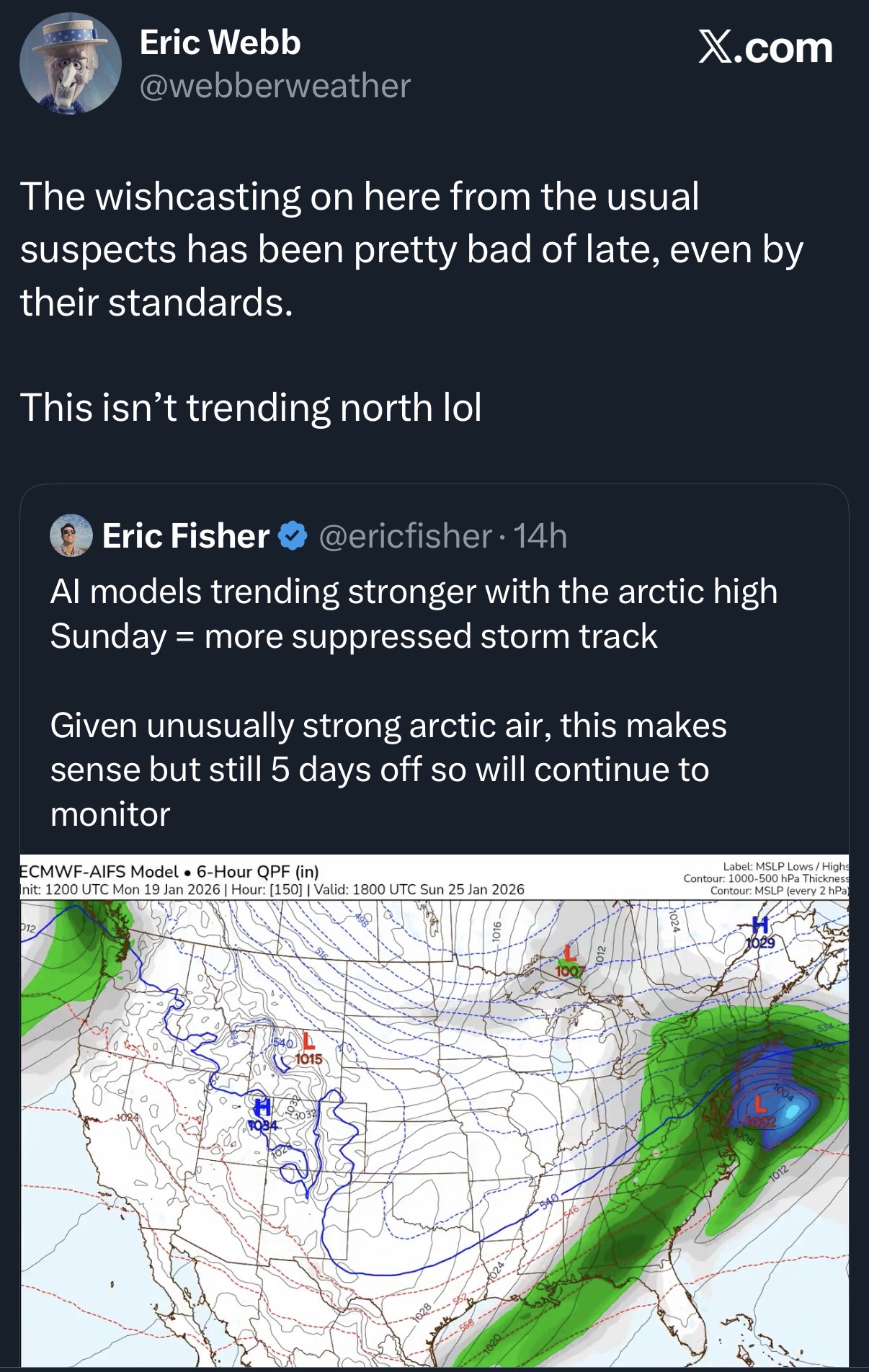
It's moving north, just incrementally. Clear trend though.

-
I just hope the GFS is right at this point. 4-8 inches of sleet would be fun frankly, and the alternative is a life threatening situation for many.
-
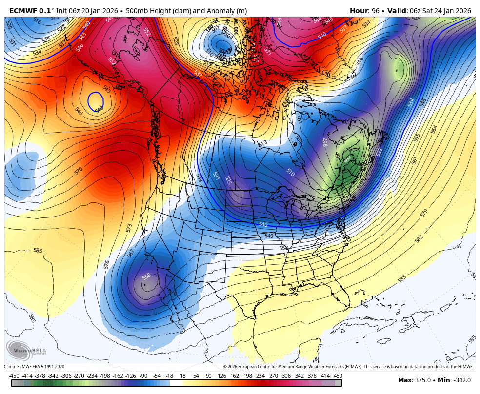
I think the TPV lobe wanting to exit stage right so quickly is what is reducing suppression and letting that HP just get caught in the flow and slide out. Side note, 6z Euro did tick back towards less interaction out west. Need a lot obviously, but trends gotta start somewhere I guess.

-
Cant wait to be posting clown maps for that one this time next week only for it to end up shifting to Miami 3 days out. It can snow to the north or the south, but never the interior southeast anymore. Prove me wrong atmosphere.
-
This needs to live in infamy forever. Just made an absolute fool of himself. Many thought he was going to do this on the last one but of course it was this one. BAM schooled him and many other southern Mets this week, they never wavered.

-
I just don't see how this one could come back at this point. It's not just one thing, but every single thing we need to trend our way going bad. Crazy model failure. Not just people falling for wild OP runs either. The ensembles were rock solid for a couple days.
-
Wow, this thing is really gonna turn into February 2021 by Saturday isn't it? Texas in the deep freeze with snow and ice, and the whole south east 50s and raining.
-
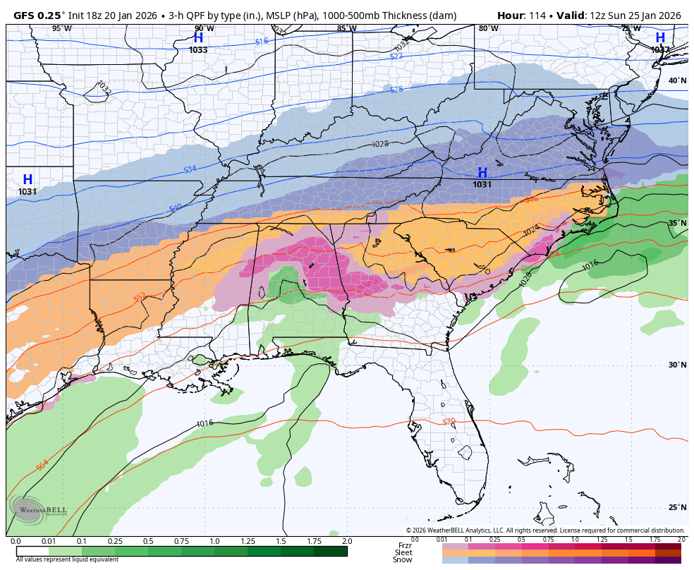
The GFS is showing tons of sleet and a much deeper wedge signature in the temps, but I suppose the timing of onset relative to the HP building in is a big factor.
-
Anyone have any explanation for the lack of sleet on the Euro? It's like all snow or all ice/rain with no in between. I guess it's just so quick with the Baja low that the wedge never gets a chance to build in.
-
Naturally Webb will have nailed the miss over the weekend and then proceed to get embarrassed on this one... Can't get a phase for years and then get screwed the second we need it strung out. Have to just laugh at the ridiculousness of it honestly lol.
-
It's really not that big of a jump if you've watched the trends with the northern shortwave getting stronger and digging further SW. It's just that once it goes far enough to fully phase, the upper level warmth wins out.
-
Warning signs for this have been pretty clear since last night. Need big changes soon with the handling of the upper level energy.