

Chicago Storm
-
Posts
19,211 -
Joined
-
Last visited
Content Type
Profiles
Blogs
Forums
American Weather
Media Demo
Store
Gallery
Everything posted by Chicago Storm
-

Winter 2025-26 Medium/Long Range Discussion
Chicago Storm replied to michsnowfreak's topic in Lakes/Ohio Valley
there's still a good spread, but a majority are a quality hit along/north of the border currently. -
Winter 2025-26 Medium/Long Range Discussion
Chicago Storm replied to michsnowfreak's topic in Lakes/Ohio Valley
bump. -
Fog was significant here the previous two nights. Had an extended period of 1/8SM at ORD on Wednesday night and Thursday night.
-
Today was a fluke, but it goes to show why the new SPC format is flawed trash. The science is currently not good enough and never will be good enough to set a min/max on hail size, wind speed and tor strength in outlooks and MD's.
-
^that's violent, to say the least.
-
https://x.com/Ham_BklynWx/status/2030018538727956893?s=20
-
Winter 2025-26 Medium/Long Range Discussion
Chicago Storm replied to michsnowfreak's topic in Lakes/Ohio Valley
poor take. -
you forgot this one...
-
Winter 2025-26 Medium/Long Range Discussion
Chicago Storm replied to michsnowfreak's topic in Lakes/Ohio Valley
alek is in your head too much. -
kinda unremarkable, if you dig into chicago weather history. it happens more than you think, that is a lack of snow during winter months at times. i'm not just talking recently over the past few years either.
-
essentially. March 2012 (53.5) was warmer than April 2012 (50.7) in Chicago.
-
Winter 2025-26 Medium/Long Range Discussion
Chicago Storm replied to michsnowfreak's topic in Lakes/Ohio Valley
looks like this will have significant pull after-all… -
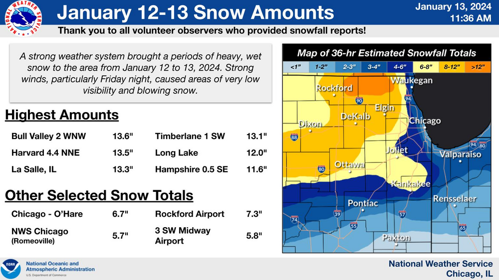
big-time model guidance fail for today's event, and even in event performance was horrendous. where upwards of 4-8" of snow occurred, the hrrr had only a dusting and the euro had only 1-3", for example.
-
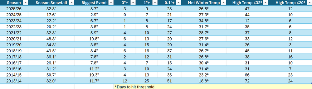
statistical information on winter in chicago, since the historic winter of 2013/14... like i've said, this is the snowiest and coldest season we've seen in years.
-
well, if you’re going that route… then the amount of snow that occurred in november is generally something that is unrealistic.
-
he’s stuck on february.
-
Winter 2025-26 Medium/Long Range Discussion
Chicago Storm replied to michsnowfreak's topic in Lakes/Ohio Valley
i can easily pull that stats and post them -
lol
-
it’s still february.
-
Winter 2025-26 Medium/Long Range Discussion
Chicago Storm replied to michsnowfreak's topic in Lakes/Ohio Valley
november and february were essentially swapped. -
Winter 2025-26 Medium/Long Range Discussion
Chicago Storm replied to michsnowfreak's topic in Lakes/Ohio Valley
Roughly just over 4" of the current seasonal snowfall total of 32.3" was pure LES. -
Winter 2025-26 Medium/Long Range Discussion
Chicago Storm replied to michsnowfreak's topic in Lakes/Ohio Valley
we've had more winter this season than we have in many years. stop your bitching lol. -
Winter 2025-26 Medium/Long Range Discussion
Chicago Storm replied to michsnowfreak's topic in Lakes/Ohio Valley
we had some severe wx events in the area. -
Winter 2025-26 Medium/Long Range Discussion
Chicago Storm replied to michsnowfreak's topic in Lakes/Ohio Valley
The SPV already split, and a SSWE is set to occur as well. -
Winter 2025-26 Medium/Long Range Discussion
Chicago Storm replied to michsnowfreak's topic in Lakes/Ohio Valley
It would be hard to pull any long term statistics regarding that. Maybe tomorrow I’ll check to see how much of the seasonal snow thus far this season was pure LES.


