Chicago Storm
-
Posts
19,232 -
Joined
-
Last visited
Content Type
Profiles
Blogs
Forums
American Weather
Media Demo
Store
Gallery
Everything posted by Chicago Storm
-

Spring 2025 Medium/Long Range Discussion
Chicago Storm replied to Chicago Storm's topic in Lakes/Ohio Valley
Just going to leave this here....png.542f931d810c600e0a006f9d234f67c9.png)
-
i’m concerned for you.
-
As with any other year… For the days/events that are not thread worthy.
-
Let’s get the ball rolling…
-
Big dust storm...
-
Winter 2024-25 Medium/Long Range Discussion
Chicago Storm replied to michsnowfreak's topic in Lakes/Ohio Valley
hunch says you will win that one. -
Winter 2024-25 Medium/Long Range Discussion
Chicago Storm replied to michsnowfreak's topic in Lakes/Ohio Valley
-
Winter (Dec-Feb) 2024/25 will finish as the 10th least snow winter on record for Chicago. Least Snow Winter's (Dec-Feb) 1. 5.7" - 1930/31 2. 6.3" - 1936/37 3. 7.1" - 1921/22 4. 7.9" - 1920/21 5. 8.8" - 1898/99 6. 11.0" - 1889/90 7. 11.6" - 1912/13 7. 11.6" - 1905/06 9. 11.7" - 1890/91 10. 11.9" - 2024/25
-
Chicago Weather Records Tracking
Chicago Storm replied to Chicago Storm's topic in Lakes/Ohio Valley
Winter (Dec-Feb) 2024/25 will finish as the 10th least snowy winter on record for Chicago. Least Snow Winter's (Dec-Feb) 1. 5.7" - 1930/31 2. 6.3" - 1936/37 3. 7.1" - 1921/22 4. 7.9" - 1920/21 5. 8.8" - 1898/99 6. 11.0" - 1889/90 7. 11.6" - 1912/13 7. 11.6" - 1905/06 9. 11.7" - 1890/91 10. 11.9" - 2024/25 -
Winter 2024-25 Medium/Long Range Discussion
Chicago Storm replied to michsnowfreak's topic in Lakes/Ohio Valley
pulling for you not to pick-up some half-assed event(s) that kills the futility chase. at least there's a 3.1" buffer between current and #1. -
Winter 2024-25 Medium/Long Range Discussion
Chicago Storm replied to michsnowfreak's topic in Lakes/Ohio Valley
counterpoint: it actually does have some. -
Winter 2024-25 Medium/Long Range Discussion
Chicago Storm replied to michsnowfreak's topic in Lakes/Ohio Valley
This one has similarities in regards to the main trough sweeping W-E across the CONUS, with it being similarly strung out and evolving as well. Also, there's a secondary wave diving in from the NW, which has some phasing potential. The big thing that is different is that this time the TPV does not exist in S Canada. -
Winter 2024-25 Medium/Long Range Discussion
Chicago Storm replied to michsnowfreak's topic in Lakes/Ohio Valley
It actually has some similarities to the event of a few weeks ago (The Detroit fader). -
Winter 2024-25 Medium/Long Range Discussion
Chicago Storm replied to michsnowfreak's topic in Lakes/Ohio Valley
My view is let people root for what they want. Everyone has their own wants. No one rooting for anything is going to change what actually happens in reality. -
Winter 2024-25 Medium/Long Range Discussion
Chicago Storm replied to michsnowfreak's topic in Lakes/Ohio Valley
Overall, between now and when we push into mid-month, it looks fairly up and down... or what you might consider a typical March. Even though things may end up warmer than average as a whole, with what will be an active weather pattern and quality cold still being replenished in Canada, there most definitely will be some snow chances around...mainly north of I-70 and especially I-80. -
everyone brings up 2011 every single year.
-
Fall/Winter '24 Banter and Complaints Go Here
Chicago Storm replied to IWXwx's topic in Lakes/Ohio Valley
We were in one a little over a week ago. -
The peak coldest temp and wind chill this week at ORD was on Monday night/Tuesday morning. The low temp was -5 and the peak wind chill was -22.
-
2/19-2/20 Significant Winter Storm
Chicago Storm replied to largetornado's topic in Lakes/Ohio Valley
i believe that we only have ever had a handful of members from that area. sort of surprising, given it’s a bigger metro/urban area. -
2/14-2/15 Potential Major Winter Storm
Chicago Storm replied to A-L-E-K's topic in Lakes/Ohio Valley
you do you, guy. -
2/14-2/15 Potential Major Winter Storm
Chicago Storm replied to A-L-E-K's topic in Lakes/Ohio Valley
yep. i get that there 'needs' to be a cop-out or fail-point. however, it isn't convective issues, it very clearly was a trend towards an even more janky H5 evolution...which carries elsewhere. -
2/14-2/15 Potential Major Winter Storm
Chicago Storm replied to A-L-E-K's topic in Lakes/Ohio Valley
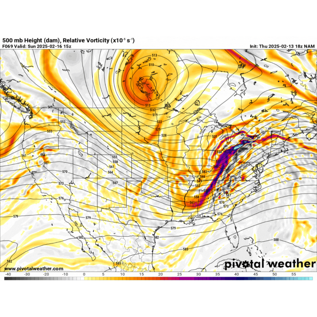
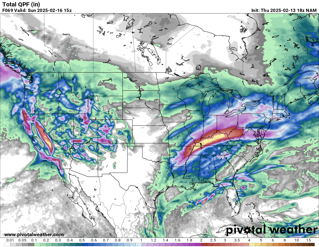
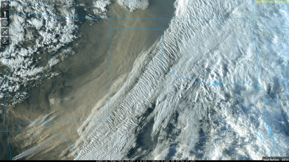
convection most definitely did not block moisture transport, as that heavy convection was modeled for days, even on guidance showing a heavier hit for MI. again, the difference came aloft, with an even jankier H5 look...which is also why the surface low kept trending east. let's take a look at the NAM, which was one of the last to let go of a snowier solution... pretty clear cut look on why things trended southeast and weaker. obviously if you trend H5 jankier, the associated surface low in turn ends up weaker/southeast, and moisture transport/850 low shunted east. also, note on the second image of the heavy convection modeled days ago.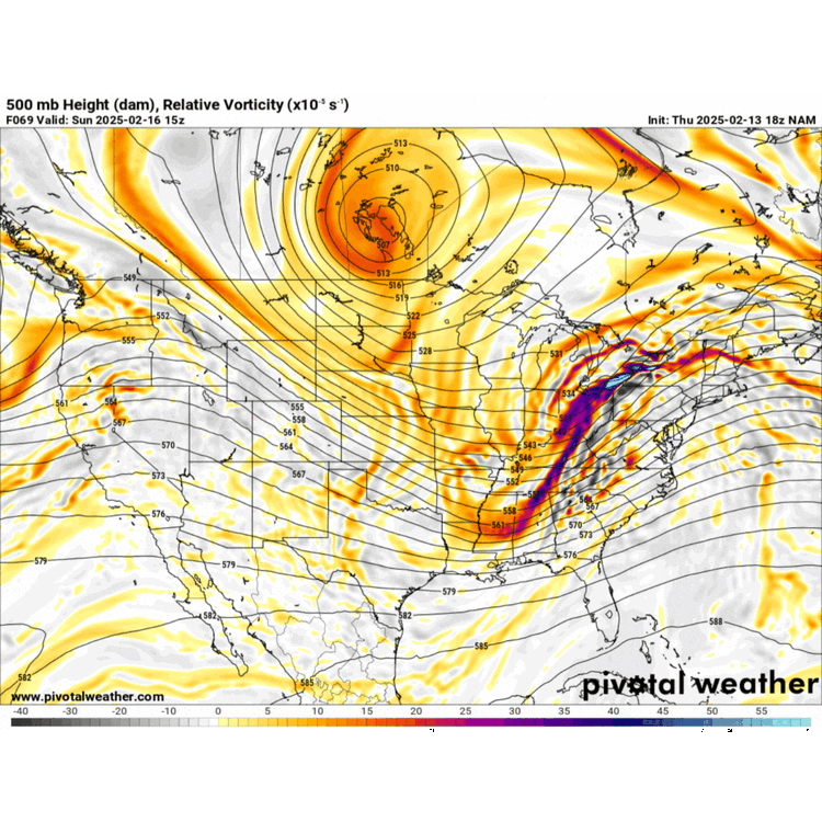

-
2/14-2/15 Potential Major Winter Storm
Chicago Storm replied to A-L-E-K's topic in Lakes/Ohio Valley
but, it’s actually not the reason. look at the H5 changes over the past few days and you have your answer. -
2/14-2/15 Potential Major Winter Storm
Chicago Storm replied to A-L-E-K's topic in Lakes/Ohio Valley
and you say i’m the asshole… -
2/14-2/15 Potential Major Winter Storm
Chicago Storm replied to A-L-E-K's topic in Lakes/Ohio Valley
WAA burst of snow this evening was as advertised. Peaked with a period of SN at ORD, with a final snowfall total of 1.8”. The seasonal snowfall total is now 14.8”.