

Chicago Storm
-
Posts
18,182 -
Joined
-
Last visited
Content Type
Profiles
Blogs
Forums
American Weather
Media Demo
Store
Gallery
Posts posted by Chicago Storm
-
-
I hope you or Izzi is doing the overnight afd lol
You don’t want the latter right now.
. -
-
1.1" at ORD and here on the 15th.
1.5" ORD and 2.5" here on the 17th.
-
 1
1
-
-
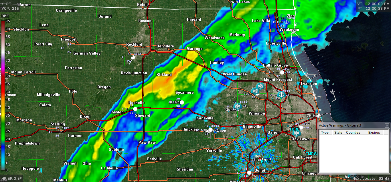
~50dbz in the band of snow in the LOT CWA...

-
Decent shift north of most guidance with this system now.
The UKMET is the farthest NW, with accums even to cycloneville. ECMWF is the farthest SE, with a DAB only to ORD. Most guidance did shift north though, enough to put much of the metro in play for some accums now.
-
Now that we're well past the last 80+ day on record...It's safe to mention 2018 will finish tied for the 3rd most 80+ days in a year for Chicago, with 101 such days.
Most 80+ Days In A Year:
103 - 2005
102 - 2007
102 - 1953
101 - 2018
101 - 2012
101 - 1963
101 - 1944
100 - 1991
98 - 2010
98 - 1987
98 - 1955-
1
-
-
2.2" here as well with Friday mornings snow.
-
High confidence in a DAB and the first measurable snow of the season around here.
.-
1
-
-
-
A lot of 88 readings on the 5 min obs at ORD, but I'm not sure if it's a real 88 or rounded (given the large number of 88 obs, my guess may be the former). If the high is 88, it would be the warmest October temp since 1997.
The high was indeed 88, at ORD and MDW yesterday.
. -
ORD was still at 80 as of the 1AM OBS last night, before showers and storms moved through with the front.
. -
1 minute ago, Animal said:
Watch the kids walk bye
nice seidel overplaying there.
-
when's the storm gonna hit?
-
1
-
 1
1
-
-
josh is chasin' the wrong storm.
-
20 minutes ago, LongBeachSurfFreak said:
If anything I think it’s been decreasing in the last couple of hours. Outflow appears to be improving on the southern side.
Shear is definitely still an issue, in addition to some dry air entertainment too as seen on WV.
-
Looking at satellite, there appears to be some southerly shear still affecting the storm.
Outflow is a bit restricted on the south side of the storm, with the southerly shear evident to the south as well.
This seems to have been a problem for the past 24-36hrs.
-
What a whopper from NJwx85
he’s been putting out the goods.
. -
7 minutes ago, the ghost of leroy said:
I’m gonna start calling it THE Hurricane Florence
could have something in common...failure.
especially when it landfalls as a cat 1 in sc after meandering offshore for days.
-
10 minutes ago, the ghost of leroy said:
this is kinda cringe, IMO
comparing anything to ohio is p bad.
-
1
-
-
CDO is once again fairly lopsided, with cloud tops on the western side showing steady warming.
Shear is definitely still an issue.
-
3
-
-
38 minutes ago, the ghost of leroy said:
sup...i'm unbanned. glad the mods saw the light and went SEP and it was fun watching you all trash njwx85, mr "this is definitely hitting as a cat 4"
anyone else think icyclone should have chased mangkut? it's looking like irma for sure

figured there was a reason behind you being so quiet.
at least he's chasing one of the two.
-
16 hours ago, Hoosier said:

well played.
-
1 hour ago, Spartman said:
Just as expected today, close to even tying a record. Topped out at 62. NWS just stuck a fork on any sunshine again for tomorrow since Gordon has seemed to have screwed up our opportunity for any enjoyable conditions, and I can feel it happen for Wednesday as well.
oh no
-
18 minutes ago, NJwx85 said:
Big difference between people posting absolute garbage in a winter storm thread to the point where it's impossible for mods to keep up and one or two people making posts in a tropical forum that could easily be handled differently.
you're right actually.
you were just handled decently.


Nov. 25th-26th Midwest Snowstorm Potential
in Lakes/Ohio Valley
Posted
Gonna go first call 8.1” for ORD.
Nice shift south of some guidance with the 12z runs. Starting to get a nice consensus on a corridor of 9-15” from MO/IA up into the LOT CWA.
.