

Chicago Storm
-
Posts
18,192 -
Joined
-
Last visited
Content Type
Profiles
Blogs
Forums
American Weather
Media Demo
Store
Gallery
Posts posted by Chicago Storm
-
-
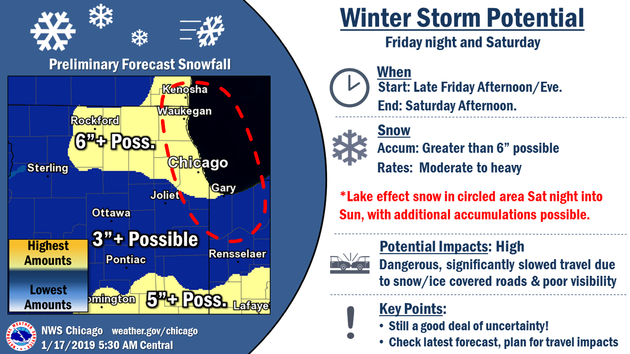
So is the right way to read this is the yellow is just lake enhancement in the first wave and any potential lake effect isn’t included?
What a change from overnight. The enhancement goes pretty far out west.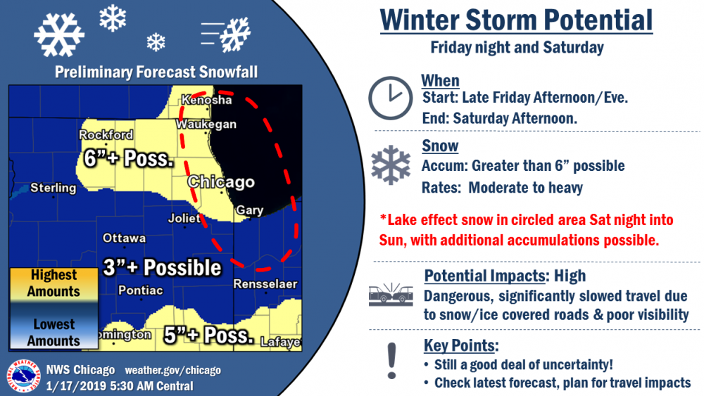
That is just synoptic/FGEN/lake enhancement.
Any pure LES from Sat/Sun is not included...and that likely will be several inches.
. -
The 6z RGEM is north again too.
1001mb SLP around Joplin at 48hr, with 500mb closed off around Topeka.
.-
 1
1
-
-
Significant LE snow post-storm for Chicago, for over 24hrs. There’s also enhancement during the storm.
. -
What a run...


. -
06z so far is continuing its trend of slower and stronger in the plains.
Big changes again, in a positive way.
Southern trough ends up going neutral tilt earlier yet again, and this run closed off 500mb over C. Kansas by 51hr. Slower a bit as you mentioned, do the the aforementioned.
. -
Grasping straws instance, but the long range RAP is even further north with the trough as ejects out into the Plains and is more neutral tilt earlier. SLP is way up in S. Kansas.
Edit: Might have to click to loop.

-
 1
1
-
-
0z EMCWF did come in further north and more neutral tilt with the trough coming into the Plains...But outside of that SLP pushes fairly east.
-
1 minute ago, mimillman said:
Winter started for Chicago last Saturday too lol
You're forgetting the November blizzard.
-
0z GEFS came in a bit south/drier.

-
2 minutes ago, Stebo said:
That is a big jump north from 12z run though.
For that time-frame, yes...but before that it is identical, and after that it's actually a bit south.
Seems like it started to push ENE, then got shunted east, as did the trough...similar to the GGEM
-
Globals vs Hi-Res...We've seen this battle before, but it's been a while.
-
0z FV actually came in a bit south aloft and with precip, but around the same for the SLP.
-
FV is coming in further north with the wave coming into the West Coast.
-
Just now, Stebo said:
It had a funny evolution and didn't go more neutral, just kept sliding east.
Very odd overall. The trough out west was so far north of 12z, then it just got kicked east. Haven't looked into it, but I'm guessing lack of phasing or some other reason.
-
1 minute ago, Chicago Storm said:
0z GGEM taking a good jump north.
Trough much further north out West and entering the Plains.
Eventually ended up further SE across the OV. Had some issues aloft...
-
1
-
-
0z GGEM taking a good jump north.
Trough much further north out West and entering the Plains.
-
0z GFS is very similar to the 18z run overall.
-
1
-
-
5 minutes ago, Hoosier said:
You're our 06z/18z Euro guy from now on.

Let's just say the 18z run had a 997mb SLP in N. AL at one point, which was actually south of 12z run at that time.
-
Just now, Hoosier said:
Supposedly the 18z Euro was a little north.
Barely. It was pitiful compared to any other 18/0z run.
-
 1
1
-
-
If you think the 0z NAM is north, try the 0z RGEM...
It only goes to 48hrs, but it has a 999mb SLP over OKC at 48hr. The NAM is ~1003MB near Fredrick, OK along the Red River.
-
1
-
1
-
-
One big observation on the 0z NAM is that the following wave crashing into the PAC NW is actually helping lower heights with the Western ridge. This might help kick our the southern trough, possibly northeast a bit eventually.
-
NAM is going to be well north, many factors in play.
-
1
-
-
NAM definitely going to be better and probably north.
Southern wave is stronger, neutral tilt trough sooner, more ridging over Midwest/OV and less ridging over Western states earlier.
-
0z NAM is coming in north with the southern wave entering the West Coast once again.
-
1
-
Winter Storm? Jan 18-19th, 2019
in Lakes/Ohio Valley
Posted
6z ECMWF might have been slightly worse than the already terrible 0z run.
.