Chicago Storm
-
Posts
19,240 -
Joined
-
Last visited
Content Type
Profiles
Blogs
Forums
American Weather
Media Demo
Store
Gallery
Everything posted by Chicago Storm
-
Today is going just about as expected, with widespread clouds and convection festering across the main area of focus. Best chance of anything will probably be from that current E IA line, if it matures a bit to the east.
-
Tomorrow still looks like a low-end risk day. Cloud cover/shower debris issues will be too widespread and significant. Only the HRRR's are interesting.
-
Tue looks like a marginal-slight worthy risk for areas near/south of I-80 in IA/IL/IN. Beyond that, I had been mentioning elsewhere for a while now that severe chances would likely increase for the Plains/Midwest for first weekend of May into the first week of May...and we have now been consistently seeing signs on longer range guidance that will likely be the case.
-
Things have sort of plateaued for a while now, so I find that hard to believe.
-
Nothing should change until there is better testing in place.... Which is something that hasn’t happened yet, and doesn’t appear to be happening any time soon. .
-
So much for that...past 24hrs has had the biggest single day case increase thus far. 27,575 cases and 1,134 deaths total now. (+1,842 & +62)
-
The range has generally been between +1,100 to +1,550 during that 10 day stretch, constantly bouncing around. So definitely not a downward trend, just more-so a leveled off steady increase.
-
Still the same leveled steady increases each day, with both cases and deaths. Sun: 20,852 cases and 720 deaths total. (+1,293 & +81) Mon: 22,025 cases and 794 deaths total. (+1,173 & +74) Tue: 23,247 cases and 868 deaths total. (+1,222 & +74) Wed: 24,593 cases and 948 deaths total. (+1,346 & +80) Thur: 25,733 cases and 1,072 deaths total. (+1,140 & +125)
-
Seems to be a steady rise each day, but nothing exponential per say... Tue: 13,549 cases and and 380 deaths total. (+1,287 & +73) Wed: 15,078 cases and 462 deaths total. (+1,529 & +82) Thur: 16,422 cases and 528 deaths total. (+1,344 & +66) Fri: 17,887 cases and 596 deaths total. (+1,465 & +68) Sat: 19,180 cases and 677 deaths total. (+1,293 & +81)
-
No doubt... Wednesday too. Even today there were a significant amount of people out and about.
-
11,256 cases and 274 deaths as of yesterday. Slightly bigger increase to 12,262 cases and 307 deaths in IL today.
-
Looks like an elevated hailer threat this evening/tonight, and then a more interesting threat tomorrow afternoon/evening.
-
NAM's have been overzealous with cloud cover, and in turn have underdone temps on almost every warm day thus far this season. So easy toss material there.
-
10,357 cases and 243 deaths as of today in IL. .
-
8,904 cases and 210 deaths total now in IL. .
-
Preparing for the next severe event?
-
7,695 cases and 157 deaths in IL now. Seem to be going back and forth between bigger and smaller jumps in case and death counts every other day.
-
I actually started working on some this evening with several states. If I don't post it tonight, I'll have it tomorrow.
-
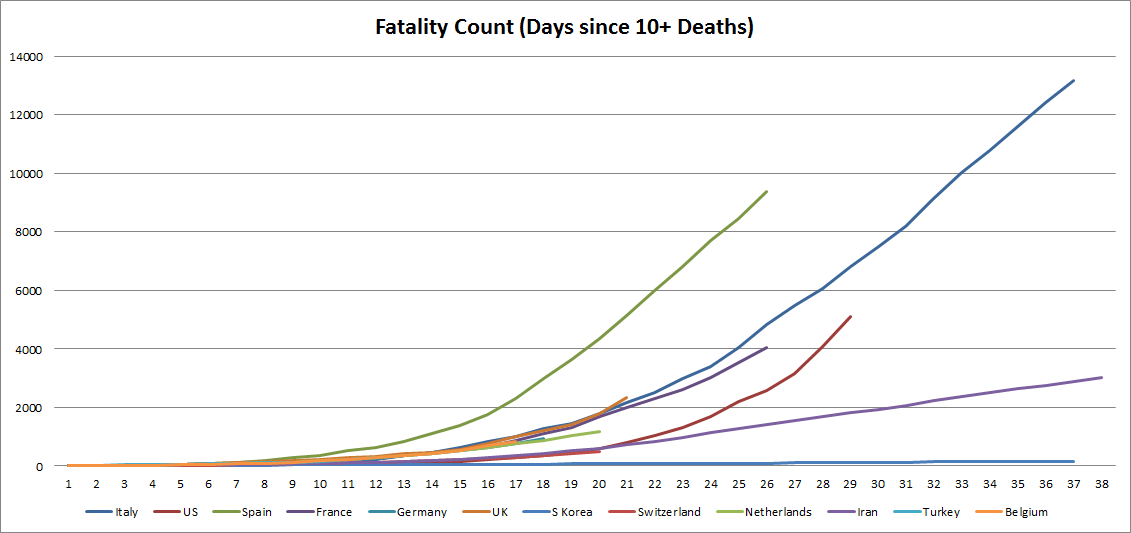
Deaths per 10k population (or something similar) would be better, but I’m too lazy to do all of that...thus the easy total count. The total count is still important too though. .
-
A graph I've been adding to, showing total fatalities in the hardest hit countries...
-
Bigger increase continues... 6,980 cases and 141 death in IL.
-
5,994 cases and 99 deaths now in IL. Back to a bigger jump with each today. .
-
5,057 cases and 73 deaths as of yesterday, which was a slower rise than on Sunday. Shall see what the numbers are for today in a bit.
-
4,596 cases and 65 deaths as of today in IL.