


Chicago Storm
-
Posts
19,292 -
Joined
-
Last visited
Content Type
Profiles
Blogs
Forums
American Weather
Media Demo
Store
Gallery
Everything posted by Chicago Storm
-

Central/Western Medium-Long Range Discussion
Chicago Storm replied to andyhb's topic in Central/Western States
Looks like this season will come down to June. Given trends and what has happened thus far, one can't really be that excited, but we'll see... -
Central/Western Medium-Long Range Discussion
Chicago Storm replied to andyhb's topic in Central/Western States
Neither of those are really "day of" issues though. -
Central/Western Medium-Long Range Discussion
Chicago Storm replied to andyhb's topic in Central/Western States
Odds are there will be some sort of severe in the Plains towards the first days of May... Still a long way out obviously, but that should be the first potential...with more at or just after mid-month and beyond. LR GFS, but it shows it as well... . -
Central/Western Medium-Long Range Discussion
Chicago Storm replied to andyhb's topic in Central/Western States
See you in June. -
Central/Western Medium-Long Range Discussion
Chicago Storm replied to andyhb's topic in Central/Western States
Looks like weatherbell. -
.
-
Central/Western Medium-Long Range Discussion
Chicago Storm replied to andyhb's topic in Central/Western States
0z GFS with the best looking potential of the season, with two quality Plains days next Wed/Thur. While it definitely looks like there will be severe in the Tue-Sat timeframe, potential multiple waves with non-stop convection and meridional flow issues are concerning at this range. -
Central/Western Medium-Long Range Discussion
Chicago Storm replied to andyhb's topic in Central/Western States
It's not good for anyone who missed the good days during that active week in late-May, as that's the only time this season really produced. Looks like the traditional chase season will end as it started. We'll see if there's any surprise events between now and the fall season. -
Central/Western Medium-Long Range Discussion
Chicago Storm replied to andyhb's topic in Central/Western States
Change that to Tuesday and Thursday-Sunday and I agree. -
Central/Western Medium-Long Range Discussion
Chicago Storm replied to andyhb's topic in Central/Western States
The first trough (Sat-Mon) is meh in terms of potential, but it does help with moisture return for the 2nd trough (Tue/Wed). As mentioned above by others, Tues looks sig on both the GFS/ECMWF. Still 6 days out, so we'll see how it progresses. -
Central/Western Medium-Long Range Discussion
Chicago Storm replied to andyhb's topic in Central/Western States
Current period (4-6th) isn't too interesting, and I suspect the 7-10th will prove to be the same. Saturday obviously has the highest potential of any day between now and Sunday, but I'm leaning heavily towards it being underwhelming due to early/morning initiation. -
Central/Western Medium-Long Range Discussion
Chicago Storm replied to andyhb's topic in Central/Western States
Don't expect another worthy chase day for me until mid-month. Upcoming pattern until that point really doesn't look like anything more than run of the mill sort of events, though as Brett stated, something interesting could pop up on short notice. -
Devastating tornado strikes Joplin, Missouri
Chicago Storm replied to Hoosier's topic in Weather Forecasting and Discussion
It's good to hear you're alright, JoMo. -
Devastating tornado strikes Joplin, Missouri
Chicago Storm replied to Hoosier's topic in Weather Forecasting and Discussion
PUBLIC INFORMATION STATEMENT NATIONAL WEATHER SERVICE SPRINGFIELD MO 400 PM CDT MON MAY 23 2011 ...EF-4 TORNADO CONFIRMED IN JOPLIN... * DATE...22 MAY 2011 * MAXIMUM EF-SCALE RATING...EF-4 * ESTIMATED MAXIMUM WIND SPEED...198 MPH * ESTIMATED PATH WIDTH...3/4 MILE * FATALITIES...116 * INJURIES...400 * THIS PRELIMINARY INFORMATION WAS DETERMINED BY A NATIONAL WEATHER SERVICE SURVEY TEAM AND IS SUBJECT TO CHANGE PENDING FINAL REVIEW OF THE EVENT AND PUBLICATION IN NATIONAL WEATHER SERVICE STORM DATA. -
Historic Tornado Outbreak April 27, 2011
Chicago Storm replied to CUmet's topic in Weather Forecasting and Discussion
As posted in the main forum topic... Here's what I have... April 27th - 12AM-11:59PM (Local Time) Tornado Count: 179 Tornado Count Per CWA: MRX: 51 HUN: 31 JAN: 30 BMX: 29 MEG: 12 FFC: 10 OHX: 9 SHV: 4 LWX: 4 AKQ: 3 GSP: 2 LMK: 2 MOB: 1 RNK: 1 RLX: 1 ILN: 1 CTP: 1 BMG: 1 -
Historic Tornado Outbreak April 27, 2011
Chicago Storm replied to CUmet's topic in Weather Forecasting and Discussion
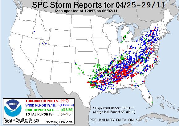
-
Historic Tornado Outbreak April 27, 2011
Chicago Storm replied to CUmet's topic in Weather Forecasting and Discussion
We now have two EF-5's... The Hackleburg, AL & Smithville, MS tor's. -
Historic Tornado Outbreak April 27, 2011
Chicago Storm replied to CUmet's topic in Weather Forecasting and Discussion
KBMX from 1-9PM. KHTX, KGWX, KDGX and KFFC would be good sites to load too. -
Historic Tornado Outbreak April 27, 2011
Chicago Storm replied to CUmet's topic in Weather Forecasting and Discussion
Will throw another one up at a later date...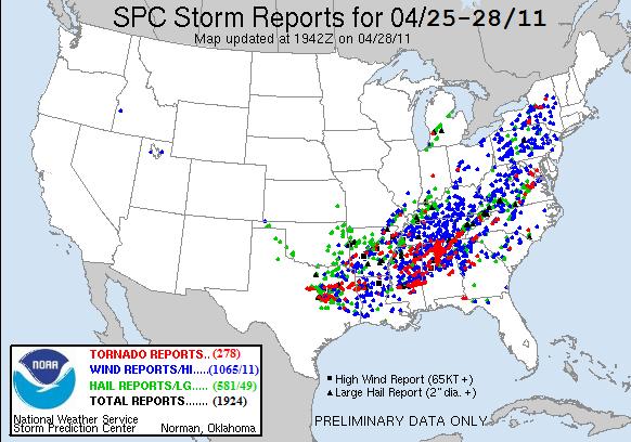
-
Historic Tornado Outbreak April 27, 2011
Chicago Storm replied to CUmet's topic in Weather Forecasting and Discussion
Just catching up on the thread after having to step out several hours ago... Just an amazing event, that's all I can say. -
Historic Tornado Outbreak April 27, 2011
Chicago Storm replied to CUmet's topic in Weather Forecasting and Discussion
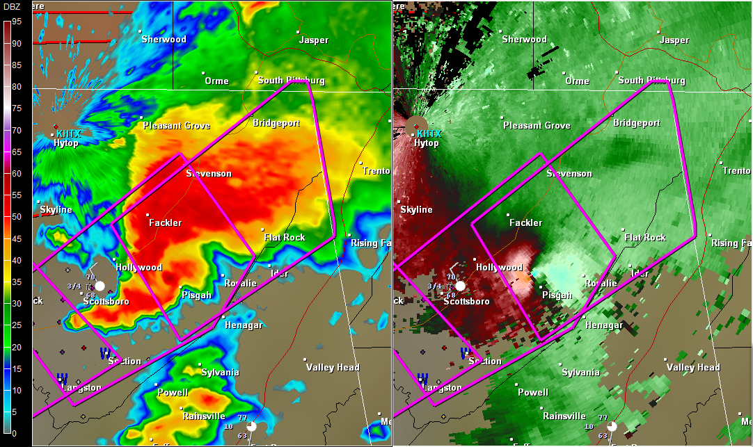
-
Historic Tornado Outbreak April 27, 2011
Chicago Storm replied to CUmet's topic in Weather Forecasting and Discussion
BWER on the tor cell near De Kalb, MS...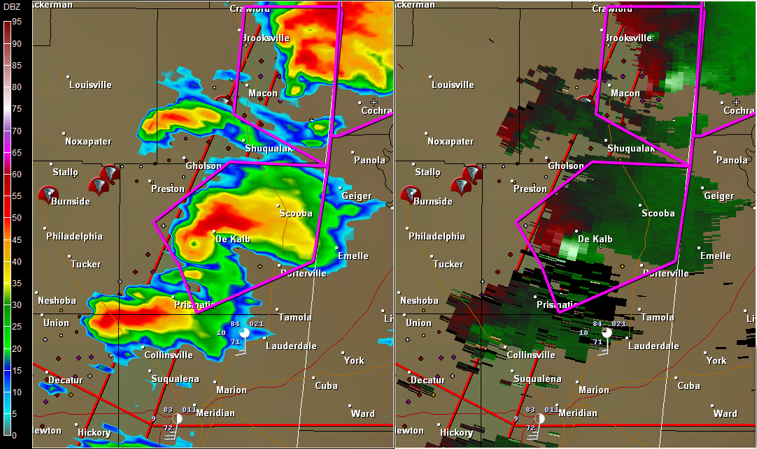
-
Historic Tornado Outbreak April 27, 2011
Chicago Storm replied to CUmet's topic in Weather Forecasting and Discussion
0153 PM TORNADO OXFORD 34.36N 89.53W 04/27/2011 LAFAYETTE MS FIRE DEPT/RESCUE TORNADO TOUCHDOWN WITH DAMAGE. EXTENT UNKNOWN. COUNTY ROADS 369 AND 469 SOUTH OF OXFORD. -
Historic Tornado Outbreak April 27, 2011
Chicago Storm replied to CUmet's topic in Weather Forecasting and Discussion
DAY 1 CONVECTIVE OUTLOOK NWS STORM PREDICTION CENTER NORMAN OK 0100 AM CDT WED APR 27 2011 VALID 271200Z - 281200Z ...THERE IS A HIGH RISK OF SVR TSTMS OVER PORTIONS OF NRN MS...AL...FAR NWRN GA AND SRN MIDDLE TN... ...THERE IS A MDT RISK OF SVR TSTMS OVER MUCH OF CNTRL AND NRN MS AND AL...NWRN GA...MUCH OF TN AND KY...WRN CAROLINAS... ...THERE IS A SLGT RISK OF SVR TSTMS FROM THE LOWER MS VALLEY/GULF COAST STATES NWD TO THE CANADIAN BORDER... ..SYNOPSIS AN UPPER TROUGH AXIS WILL BE CENTERED ACROSS THE SRN PLAINS AT 12Z WED...WITH A 100 KT MID LEVEL JET ACROSS N TX. THIS FEATURE WILL STRENGTHEN THROUGH 00Z AS IT EJECTS NEWD ACROSS THE LOWER MS AND INTO THE TN/OH VALLEYS DURING THE DAY. AT THE SURFACE...LOW PRESSURE IS FORECAST TO BE OVER W CNTRL AR AT 12Z...WITH A DEVELOPING COLD FRONT TRAILING SWWD INTO ERN TX. THESE FEATURES WILL MOVE RAPIDLY ENEWD...WITH THE SURFACE LOW NEARING SRN INDIANA BY 00Z AND A SHARP LOW PRESSURE TROUGH EXTENDING SWD INTO CNTRL KY...MIDDLE TN...ERN MS AND WRN AL. AHEAD OF THE FRONT...A VERY WARM AND MOIST AIR MASS WILL ALREADY BE IN PLACE BY MIDDAY WITH 68-72 BOUNDARY LAYER DEWPOINTS LIKELY FROM THE GULF COAST INTO MS/AL...AND MID TO UPPER 60S F OVER TN AND SRN KY WHERE SUBSTANTIAL MORNING CONVECTION WILL LIKELY BE ONGOING. WITH RELATIVELY COOL TEMPERATURE PROFILES ALOFT...AN EXTREMELY UNSTABLE ATMOSPHERE WILL RESULT ACROSS THE WARM SECTOR. WIND FIELDS THROUGHOUT THE TROPOSPHERE WILL STRENGTHEN WITH THE APPROACHING TROUGH/JET MAX...AND THE COMBINATION OF THE TWO IS EXPECTED TO RESULT IN A TORNADO OUTBREAK...WITH LONG-TRACKED STRONG TO VIOLENT TORNADOES POSSIBLE OVER THE HIGH RISK AREA. TO THE E...THE BROAD SLY FLOW ACROSS THE WARM SECTOR WILL EXTEND INTO THE MID ATLANTIC REGION...WITH A SECONDARY MOIST PLUME OFF THE ATLANTIC NWD INTO THE CAROLINAS AND WRN VA BY AFTERNOON. --- AN OUTBREAK OF TORNADOES AND DAMAGING WINDS IS EXPECTED TODAY THROUGH EVENING OVER PORTIONS OF NRN MS...NRN AL...TN AND KY. --- ..LOWER MS VALLEY INTO TN/OH VALLEYS A COMPLICATED FORECAST SCENARIO WILL UNFOLD TODAY...BEGINNING RATHER EARLY IN THE PERIOD OVER SRN AND ERN AR AND NRN LA. MODELS ARE IN RELATIVELY GOOD AGREEMENT WITH THE PLACEMENT OF THE SURFACE LOW OVER AR BETWEEN 12-15Z...THEN DEVELOPING IT NEWD ACROSS TN/KY BY 00Z. NUMEROUS THUNDERSTORMS WILL BE ONGOING...AND SOME WILL BE SEVERE...FROM NRN LA/SRN AR EWD ACROSS NRN MS...WRN AND MIDDLE TN AND KY. DESPITE TIME OF DAY...PRESENCE OF RICH LOW LEVEL MOISTURE WILL RESULT IN LITTLE CAPPING AND SURFACE BASED EFFECTIVE PARCELS. THUS...A TORNADO AND DAMAGING WIND THREAT WILL BE PRESENT WITH THIS ACTIVITY. SOUTH OF THE ONGOING ACTIVITY...STRONG DAYTIME HEATING WILL OCCUR. WITH BOUNDARY LAYER DEWPOINTS IN THE LOW 70S F...THIS WILL CREATE STRONG TO EXTREME INSTABILITY OVER MS AND AL NWD TO THE ONGOING CONVECTION. A CAPPING INVERSION WILL LIKELY KEEP MUCH OF THE WARM SECTOR S OF THE EARLY STORMS CAPPED...ALLOWING A BUILD UP OF INSTABILITY TO BE RELEASED WHEN LARGE SCALE FORCING ARRIVES DURING THE AFTERNOON ALONG THE COLD FRONT AND ESPECIALLY NEAR THE FRONT/OUTFLOW BOUNDARY INTERSECTION. THE RESULT WILL BE FAST MOVING TORNADIC SUPERCELLS CAPABLE OF STRONG TO VIOLENT TORNADOES. GIVEN THE FAST STORM MOTIONS AND RELATIVELY WIDE WARM SECTOR...SOME TORNADOES COULD BE LONG LIVED. THE GREATEST THREAT FOR THESE TYPES OF STORMS WILL BE OVER THE HIGH RISK AREA...OVER NRN MS AND AL...INTO EXTREME NWRN GA AND SRN MIDDLE TN. THIS ACTIVITY WILL PERSIST TO THE E...BUT CELLS MAY EVENTUALLY MERGE INTO MORE OF A QLCS STRUCTURE CAPABLE OF PARTICULARLY DAMAGING WINDS AND A FEW TORNADOES. ..WRN NC/VA A CONDITIONAL SEVERE THREAT WILL EXIST BY LATE AFTERNOON OVER WRN NC/VA. STRONG HEATING WILL RESULT IN STEEP LOW LEVEL LAPSE RATES...BUT FORECAST SOUNDINGS SHOW A CAPPING INVERSION AROUND 700 MB...WHICH SHOULD KEEP THE AIR MASS CAPPED. HOWEVER...MOISTURE ADVECTION...AS WELL AS SELY UPSLOPE FLOW MAY RESULT IN ISOLATED THUNDERSTORMS DURING THE AFTERNOON OVER THE HIGHER TERRAIN. WIND PROFILES WOULD FAVOR SUPERCELLS...CAPABLE OF PRODUCING TORNADOES HAIL AND WIND. WILL MAINTAIN LOW PROBABILIITES FOR THE DAYTIME CONVECTION. ..JEWELL/ROGERS.. 04/27/2011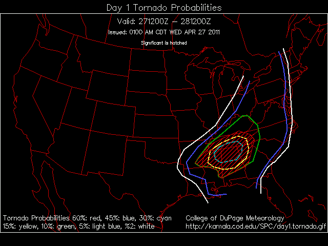
-
Historic Tornado Outbreak April 27, 2011
Chicago Storm replied to CUmet's topic in Weather Forecasting and Discussion
Tuesday's thread... http://www.americanwx.com/bb/index.php/topic/17704-april-26th-severe-weather/
