Chicago Storm
-
Posts
18,671 -
Joined
-
Last visited
Content Type
Profiles
Blogs
Forums
American Weather
Media Demo
Store
Gallery
Everything posted by Chicago Storm
-
what busted?
-

2/14-2/15 Potential Major Winter Storm
Chicago Storm replied to A-L-E-K's topic in Lakes/Ohio Valley
this is not an inspiring look.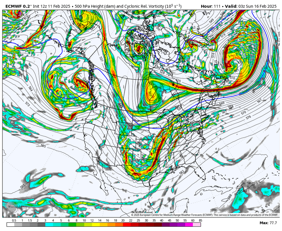
-
it's a shame that this large-scale set-up is gonna go to waste. all of the pieces were in place, but smaller scale alignment of one or two things will be preventing the goods.
-
thought you were ok with 3"?
-
Last 6”+ event: Jan 12-13th, 2024. (6.7”) Last 8”+ event: Jan 30-31st, 2021. (10.8”)
-
i thought it dusted out?
-
definitely not. at least not yet…
-
A glaze of ice accumulation and 0.1” of snowfall accumulation at ORD yesterday. That 0.1” of snow was enough to push the seasonal snowfall total up to 10.0”.
-
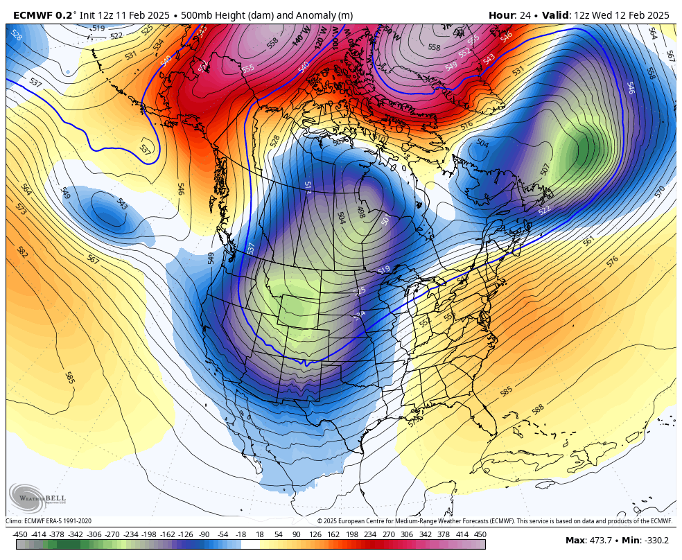
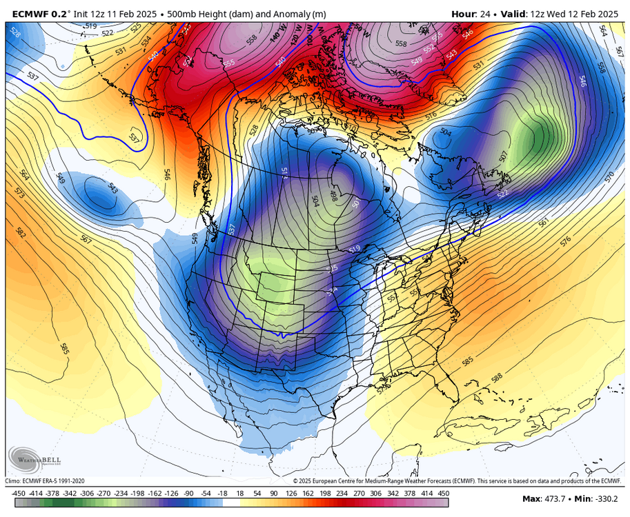
This is a top of the line look overall, with a lot of boxes checked. There's a lot going on here, which is why I mentioned in the medium/long range thread that this is one of the most complex large scale patterns that we've seen in quite a while. The typical Hudson TPV is displaced to the southwest, with a consistent 50/50 low around the Labrador Sea. We have not seen this placement of the TPV much over the past several years. Notice all of the significant ridging up near the pole, which is a product of a split of the SPV. It's not always that we see SPV effects translate immediately, but in this case we are. Also notice the positive height anomalies present in the East/Southeast, a product of a Southeast ridge. This is representative of the MJO, which has been translating through high correlation warm/East ridge favored phases. Heading into this pattern, we once again had a -EPO/Alaska ridge, which once again helped to re-charge Canada cross polar flow cold.
- 605 replies
-
- 12
-

-

-

-
good vibes with this.
-
Winter 2024-25 Medium/Long Range Discussion
Chicago Storm replied to michsnowfreak's topic in Lakes/Ohio Valley
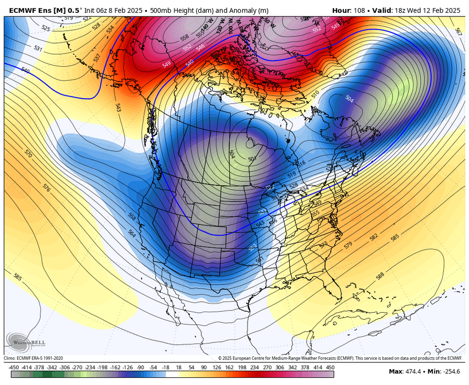
I'll try to push something out here soon. Busy-busy-busy these days. In general, this period, which has already kicked off, will be the most active stretch of the winter. Words of wisdom would be to watch the period around Feb 12th next week. That's the best looking setup for a 'dawg' that we've seen all winter in this region. (Yes, I know that the early January needle/threader was a dog in the far southern portion of the sub-forum, but that was not a blatantly obvious slam dunk look). -
Winter 2024-25 Medium/Long Range Discussion
Chicago Storm replied to michsnowfreak's topic in Lakes/Ohio Valley
guy… you really need to get over it. our climo is what it is. you can’t just come up with this idea that it should be magically better just because you want it to be. as many of us have said, you live in the wrong place for what you’re looking for. either you can’t quite grasp the reality of things or you’re one of the best trolls we’ve seen. -
Chicago Weather Records Tracking
Chicago Storm replied to Chicago Storm's topic in Lakes/Ohio Valley
it didn’t cross my mind to look through the 7th (or beyond) for a stat on a graphic that was shown on the 6th. so yes, they were incorrect. the only thing dense around here has been your posting. -
Chicago Weather Records Tracking
Chicago Storm replied to Chicago Storm's topic in Lakes/Ohio Valley
It's actually wayyy off. The correct answer is, this is the least total snowfall through Feb 6th in a season since 9.2" through Feb 6th during the 2012/13 season. -
Winter 2024-25 Medium/Long Range Discussion
Chicago Storm replied to michsnowfreak's topic in Lakes/Ohio Valley
We're sliding into probably one of the more complex large scale weather patterns that we've seen in quite a while. -
0.15" of ice accumulation at ORD yesterday evening and last night. There was a solid glaze+ on all surfaces.
-
This looks like a fairly minor "event" around here... Probably a glaze of ice and dusting of snow/sleet/ice pellets. The Euro was most bullish for a while, but then collapsed to the rest of guidance.
-
kind of already do have one...
-
Winter 2024-25 Medium/Long Range Discussion
Chicago Storm replied to michsnowfreak's topic in Lakes/Ohio Valley
That last part of this is important. The battle appears to be indeed coming. The look has transitioned from long range to the mid range, and soon to be short range. -
Final storm rainfall total of 1.75" at ORD. Prior to this event, Chicago/ORD was on the brink of a top 5 dry January on record.
-
Winter 2024-25 Medium/Long Range Discussion
Chicago Storm replied to michsnowfreak's topic in Lakes/Ohio Valley
long range “forecasting” for an entire winter or cold season is essentially just long range guessing. if you’re right, you got lucky. if you’re wrong, you were destined to be anyway. these long range winter forecasts that are issued by many in the fall are the most pointless kind of “forecasting” there is. stick with getting the short term correct and worry less about the super long term. -
enter the crowd: “just think if this were snow”.
-
super-soaker.
-
Winter 2024-25 Medium/Long Range Discussion
Chicago Storm replied to michsnowfreak's topic in Lakes/Ohio Valley
The warm anomaly correlation relaxes, but it still is there a bit. Things this winter have not been MJO dominated, however, due to the constant re-charge of cold in Canada...Which is a big result of the frequent ridging around/near AK and vicinity (Among other things). Instead, it has sort of been a mix of cooperation between the two and also a battle...with the battle upcoming. -
The Chicago high temp record for tomorrow is an unimpressive/low hanging fruit record. It is the only record after the 22nd that is not 60+.