
PowellVolz
-
Posts
3,587 -
Joined
-
Last visited
Content Type
Profiles
Blogs
Forums
American Weather
Media Demo
Store
Gallery
Posts posted by PowellVolz
-
-
Moderate sleet under these returns in North MS 30 minutes south of Memphis.. Very little snow. Looks like all the snow is along and north of I-40. Sleet showers to the south.
I haven’t kept up with what should be going on in that area. According to the mods, should it be snowing there?
. -
Yep. Very true. Also, a northwest jog has been discussed for several days. It is one reason I try not to be too emotional about modeling. The wx is gonna do what it is gonna do...and not a thing I can do about it but observe, predict, and revise...and enjoy the process. This is a fun hobby for the most part.
And you all do a fantastic job, all of you. I’m newer to winter weather even though we did this on VQ for a long time. My interest has always been severe weather, thunderstorms.
.-
 3
3
-
-
18z RGEM...surface temps are an issue for Chattanooga as is decreased overall precip. Sleet and ZR mixed w/ rain and snow. Not sure I buy that, but the WxBell algorithm has it.
My bad… I was thinking the concern was around 700
. -
I approve of this new idea.
I wouldn’t call it new. It was somewhat expected if you go by the mods under est the northern precip field
.-
1
-
-
We were 7 degrees over projected highs at TRI today.
I was a couple under. Stuck at 38-39.
. -
FWIW my temp is completely stalled at 44 DP 30 for the past 2 hours. Not sure the CF is making much progress. That may lend more credence to the NAM. I'm in a really bad spot for this one though. Almost as far SE as you can get in Hamilton county.
I could be wrong but I don’t think surface temps are the issue anywhere.
. -
-
3k NAM trended SE and expanded northern precip shield.
This is what I was looking to happen. Mods don’t handle the northern side of the precipitation very well in these setups.
. -
I'm fairly sure he's going to be wrong but we'll see. OHX just said 4-7 with 8+ possible over his 1-3 area.
Completely agree but I do believe it’s very reasonable for anyone north of 40 in the valley to push 8”. I’m in a location where I get 6-8” from the NAM and 8+ from all the other mods. I might end up in a good location.
.-
2
-
-
Captain accurate raising totals in ETn….

.-
1
-
-
25 this morning and currently 34 degrees. The true Arctic air is over the Mid-State and hasn't made it to here yet.
I was actually thinking about this earlier… we are moving mid 30’s degree temps out of the way. Usually it’s mid 50’s to 60ish or something. Seems like that would cause less drag with the cold front moving in. Thoughts?
.-
1
-
-
Was just getting ready to post that. I like following OHX graphics as they show my area generally in the graphic. Gives me an idea what their thoughts are for western areas of the MRX CWA.
The one great thing about twitter is being able to know what’s going on down stream. Not getting into the other side of social media but for weather itself, it’s probably one of the greatest assets since the Doppler radar was invented IMO.
.-
2
-
-
Nashville NWS looks like they are riding the NBM. That has continued to tick up with a lollipop over the Central Valley.

.-
2
-
-
Soak it up fellas

.-
8
-
-
Here’s another… never seen anything like this…
https://x.com/_mlfootball/status/1746329126590398669?s=42&t=i7se-trklKrDVvM1_ovOTQ
.-
2
-
-
Y’all think it’s cold? KC last night

.-
2
-
 5
5
-
-
Looks like almost all the models are showing the heaviest band to setup just south of Knoxville. Through Monroe, Blount, & Sevier counties. Still looks great for most everyone though.
It’s where the moisture is banking up against the Apps and backing into the valley. Its been suggested that it could be under done
.-
3
-
-
There's a stark ratio contrast from N to S across East Tennessee. It's less so the further west you go. I generally hover around 14:1 through the event. 11:1 around I-40 but it gets as low as 5:1 in Northeast Alabama and NWGa.
I was counting on 14:1 north of 40 in ETn. Is that too steep?
. -
It's also mixing down here. Kuchera is lower than 10:1.
Is the mixing at the end of the event when we start to lose rates?
. -
Anyone else thinking 3-6” in and around Knoxville could be a little light?
.-
5
-
 1
1
-
-
The middle to the end of December @Carvers Gap gave us 3 dates. The 7th, 12th and 22nd. He’s going 1 for 3 which is pretty incredible if you ask me.

-
8
-
-
Lol… close up of ICON

.-
3
-
-
Latest ICON
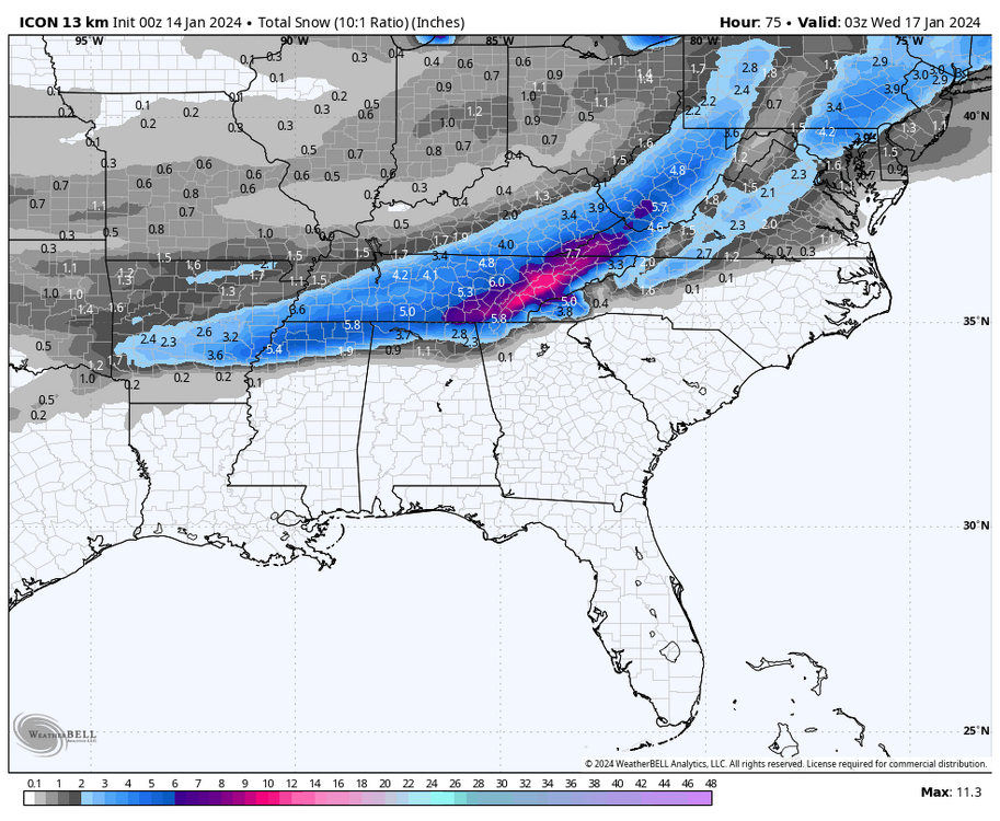

.-
3
-
1
-
-


January 15th-17th 2024 Arctic Blast/Snow Event
in Tennessee Valley
Posted
Because I’m not familiar with overrunning setups, is rate driven dynamic cooling in play for our southern valley friends?
.