
PowellVolz
-
Posts
3,587 -
Joined
-
Last visited
Content Type
Profiles
Blogs
Forums
American Weather
Media Demo
Store
Gallery
Posts posted by PowellVolz
-
-

V3
.
-
 1
1
-
 2
2
-
-
18z GEFS mean....I think this is the best so far. Its snow axis went a bit south compared to the 12z GEFS.

Good news
.-
2
-
-
Icon is warmer I believe but not sure we were considering it anyway
.
-
1
-
-
Same trowel feature as euro...onto 18z!
Now the party gets started
. -
Hopefully the Knoxville peeps will check back in. Those are just crazy snow totals. From an analysis standpoint, the high pressure over the top was 1-2mb stronger and pressing more than 0z. You could see it right away on that run. It also did not get out of the way. Looks like the TROWAL(?) pivoted over this area.
North Knox Co checking in. I’m usually here but I don’t post much.
.-
3
-
-
Interesting that this time last year parts of Atlanta had over a foot of snow and here we are again.
.-
2
-
-
Roan Mt looks to still be below freezing.

.-
1
-
-
Getting a little hopeful for you [mention=15050]BlunderStorm[/mention] , at least through early afternoon. Even though warm air advection is apparent on SPC mesoscale analysis, it doesn't seem quite as pronounced at 850mb the further southeast you go along the boundary. In fact, the correlation coefficient on the Jackson, KY radar http://weather.cod.edu/satrad/nexrad/index.php?type=JKL-N0C-1-24 seems to show the rain/ snow line meandering southward, although stalling now a bit. Precip. rates in what's heading your way look good, so I wonder how this will play out since the more impactful warm nose looks to be still up toward Louisville.
Upper E Tennessee to me seems to hold the cold in much longer than expected. I’m guessing the way the Cumberland’s meet the Apps makes a road block.
.-
2
-
-
I live in Halls and got under this enhancement. At 12:30am I woke up and it was snowing. I went back to bed but woke up to Todd Howell tweeting at 2:30am that it had just started snowing at Ch10. That’s 2 hours at least it took for snow to make it to Knoxville from my house and it’s a 15min drive. So at 2:30 I get up to look outside and we had at least an inch and it was snowing as hard as I’ve seen in a while. Went back to bed and when I woke up at 6 for work, at least have of the snow had melted on the grass but on my glass patio table I measured 1.5” inches.
.
Just to add.... at 2 o’clock in the afternoon I was in the Copper Ridge area of North Knox Co. At my house 1k feet all of the snow was gone but just a 5 mile drive to that area and 300-400ft higher in elevation the snow was still on the ground and in the trees.
.
-
We've had some nice snow near downtown Knoxville, but that extra urban heat definitely takes its toll on anything's ability to stick. Not really disappointed for myself, but in fact happy that many of you are getting snow!
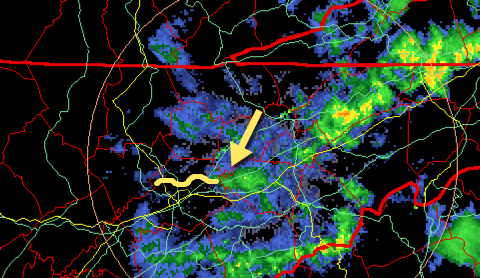
If anyone wants to see something unique, go to http://weather.cod.edu/satrad/nexrad/index.php?type=MRX-N0Q-1-200 this AM before the data expires and watch across north Knox county. There some weird mesoscale band that seems to set up after the flow turns as the front comes through yesterday afternoon and runs W to E from maybe Powell toward House Mountain. I've included an image that shows a piece of it and what to look for, but it really isn't evident until you watch the 200 image loop a couple of times. It seems to only last as long as the precip is flowing from W to E.
Would be interested to hear any thoughts on this...
I live in Halls and got under this enhancement. At 12:30am I woke up and it was snowing. I went back to bed but woke up to Todd Howell tweeting at 2:30am that it had just started snowing at Ch10. That’s 2 hours at least it took for snow to make it to Knoxville from my house and it’s a 15min drive. So at 2:30 I get up to look outside and we had at least an inch and it was snowing as hard as I’ve seen in a while. Went back to bed and when I woke up at 6 for work, at least have of the snow had melted on the grass but on my glass patio table I measured 1.5” inches.
.
-
1
-
1
-
-
This is crazy. Snowing hard at my house and 33’ degrees, 1/2” inch or so on the ground already.
.-
2
-
-
I hate to see this cause people could be dying right now but I’ve never seen a sig like this.

. -
This is pretty stable air correct?

. -
The 18z NAM 3km looks ominous for E Tennessee

. -
-
Gonna be a wild day south and west of 40/75.
. -
MRX disco this morning is interesting....
“Model soundings show the potential of large hail and damaging
winds. MLCAPES of 1000-1500 J/kg, Hail CAPES of 300-600 J/Kg,
lapse rates near 7 C/km, and WBZ Heights near 7kft support large
hail. The 0-6km shear of 60kts also support rotating storms with
more sustain updrafts. SHIP values between 1 and 1.5.
As for the convective damaging winds, melting hail, plenty of dry
mid-level entrainment and mid-level winds of 30-40kts supports
potential of damaging winds.
The potential strong convection will emain during the evening
hours with showers diminishing after midnight”
.

Winter 2018-2019 Observations
in Tennessee Valley
Posted
I’m about to get a little snow

.