
PowellVolz
-
Posts
3,587 -
Joined
-
Last visited
Content Type
Profiles
Blogs
Forums
American Weather
Media Demo
Store
Gallery
Posts posted by PowellVolz
-
-
Thank you to whoever posted the retired Met twitter post earlier...it unlocked the key. The driver of this system is a 700 jet streak...NAM was up in middle KY, everyone else Middle TN...NAM took a half step that direction. You wanna be on the right side entrance of that jet (basically south side of it)
I believe MRX mentioned something like that either this morning or yesterday.
I was looking at the 500 MB maps earlier and I noticed what looked like the possibility of some divergence aloft with a slight split flow on the right exit of that jet. I didn’t say anything about it because I wasn’t sure how much was enough to make a difference.
. -
Yeah I suspect they might consider pulling Hamilton County out of the WSW, and maybe change it to Advisory and add Bradley, Polk and SW NC counties. Though there is a strong case to leave Hamilton County in the WSW since portions of the county meet the criteria for WSW. I think Overnight shift at MRX will likely pull the trigger. For western areas of the CWA may begin before dawn. My point forecast I have 40% change of snow beginning at 1AM Monday morning.
I should have been more specific and said the border counties. I feel like everything north of a line from Cleveland Tn to the Tn/AL/Ga intersection is in warning criteria IMO.
.-
 2
2
-
-
I’m thinking MRX might wait until tomorrow afternoon for the southern valley hazards.
.-
1
-
-
Bring it
.-
2
-
-
No they don’t and that has me a little disconcerted I am right on the line in West Knox and that gives me maybe 2 in.
I actually think west Knoxville is in a great location
.-
1
-
-
The SREF plumes are a mess for TYS. P-types all over the place. Hoping the NAM suite gets itself sorted out soon.
The 15-20 miles between us and TYS is pretty significant for this system IMO.
.-
2
-
-
I’m about to stick a fork in East TN. It’s been horrible trends the last 24 hrs. I feel we will be lucky to see 2” in the upper valley. Hopefully we get a good system come through in Feb. We are ridiculously overdue a good snow.
I actually feel better this afternoon than I did this morning.
.-
1
-
-
Not quite there yet, but chance (maybe). What's something else that has to get pushed out? The low level moisture that also banks up to the mountains. Sometimes it gets pinched and trapped, especially across NE TN and Central foothills. Lucky to pick that up on modeling 12-24 hrs out.
That’s a great point. The exact flow or stream of moisture (direction) would probably determine which micro climates could come into play.
.-
1
-
-
Absolutely! I think there will be a long band that over performs by potentially several inches.
Yes I agree. I think someone in this area…..
.-
2
-
-
Anyone else feel like there’s an opportunity for someone in the valley to over perform?
.-
6
-
-
What Tellico is mentioning is different IMO. I lived in JC for five years as well - love the upslope events! It isn't really a downslope. It is banking warm air up against the Apps as it gets pushed across the valley. Amazing modeling can even model that TBH.
But since we are not dealing with sinking air, it would be much easier to overcome with rate driven dynamics IMO.
. -
I can’t remember the date of this storm but (maybe 2017-2019) it feels like this outcome could be a similar situation. It was a snow/rain/snow forecast for the valley, heavy snow on the plateau with mostly rain in the foothills because of downsloping. The warm nose made it to I-40 in Knoxville up against the mountains but did not make it any further NW. I ended up with over 8”. The thought was we had a little CAD up against the eastern slopes of the Plateau that backed up into the valley. John got blasted that event. I remember watching the temps rise as the day went on. Gatlinburg was low 40’s, Knoxville made it to 35° but I stayed below 30. One of those rare times when the cold air won out in the valley.
.-
2
-
-
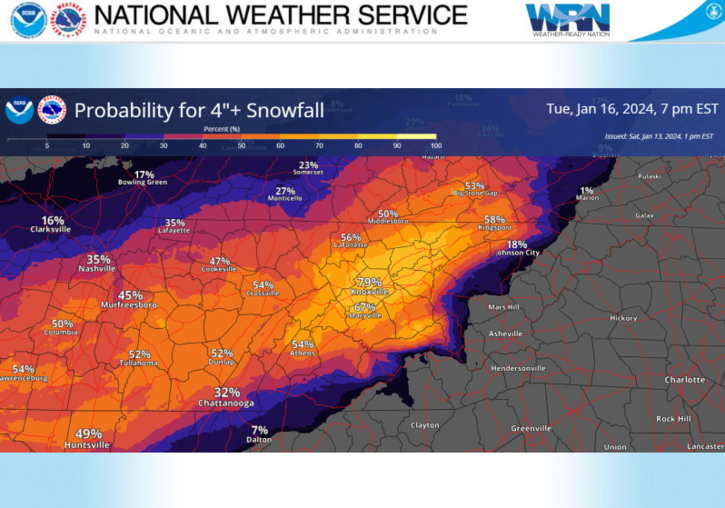
Nice writeup by MRX
.LONG TERM... (Sunday night through next Saturday) Issued at 330 PM EST Sat Jan 13 2024 Key Messages: 1. Probability for an accumulating snow Monday into Tuesday is increasing. See Winter Storm Watch for additional details. Uncertainty regarding high temperatures especially in the southeastern part of Tennessee.
2. Very cold temperatures in the wake of the potential snow. Single digit temperatures and near or subzero wind chill possible Wednesday morning.
3. Additional wintry system possible Thursday night into Friday, details highly uncertain.
Discussion: Still on track for a significant winter storm for Eastern Tennessee and southwest Virginia. A 140 knot jet aloft will develop ahead of the upper trough dipping out of Canada. Closer to the surface low level convergence and strengthening isentropic lift will provide for a corridor of snow to develop. Expect snowfall to develop over eastern Tennessee Monday morning, with exact timing still a little unknown. Despite continued waffling in deterministic runs on exact track of the snow Monday into Tuesday, ensemble probabilities are increasing for not only accumulating snowfall, but several inches of snowfall. NBM probabilities and some guidance suggest localized higher amounts of snow, but there are some caveats. Biggest concern outside of exact track of the heaviest snow is temperatures on Monday. Guidance has a bifurcated solution set, with a multitude of members showing near or subfreezing temperatures as daytime highs, but some members, including the NAM, show temperatures getting above freezing on Monday in the southeastern portions of Tennessee. That could spell spoiler, at least in the southernmost counties and lower elevations of the foothills where those warmer temperatures reside. The northern portions of Tennessee and Virginia are likely to remain below freezing, allowing for quick accumulations. Beyond the snow, we`re in for a spell of absolutely frigid temperatures. Euro and GFS ensembles are keying on high probabilities of single digit temperatures Wednesday morning, with the best chances for temperatures 20 to 30 degrees below normal values in line with where the ensembles have snow accumulations. It is quite possible for many locations that once we slip below freezing Sunday evening, we will not get back above freezing until Thursday afternoon. After that we have another shortwave trough accompanied by a much larger upper trough digging into the Ohio River valley Thursday night into Friday that will bring with it another chance of wintry weather. Once the whole upper trough swings through, that will potentially bring another shot of significant cold to the region. Ensembles have very low probabilities of valley snow, but near 50% chance for an accumulating snow in the mountains, which is pretty good signal for the high elevations at the day 6 range. &&
I’m I reading this correctly that MRX isn’t really all that concerned with PType issues outside of the lowest elevations of the southern valley?
.-
1
-
-
Here is the comparison map for the 18z RGEM (12z on right) and also 18z icing map. Most significant winter storms have mixing issues weather NYC or Boston or here. The entry point into the eastern valley is eastward. TRI's numbers are up. Overall, a pretty steady run.
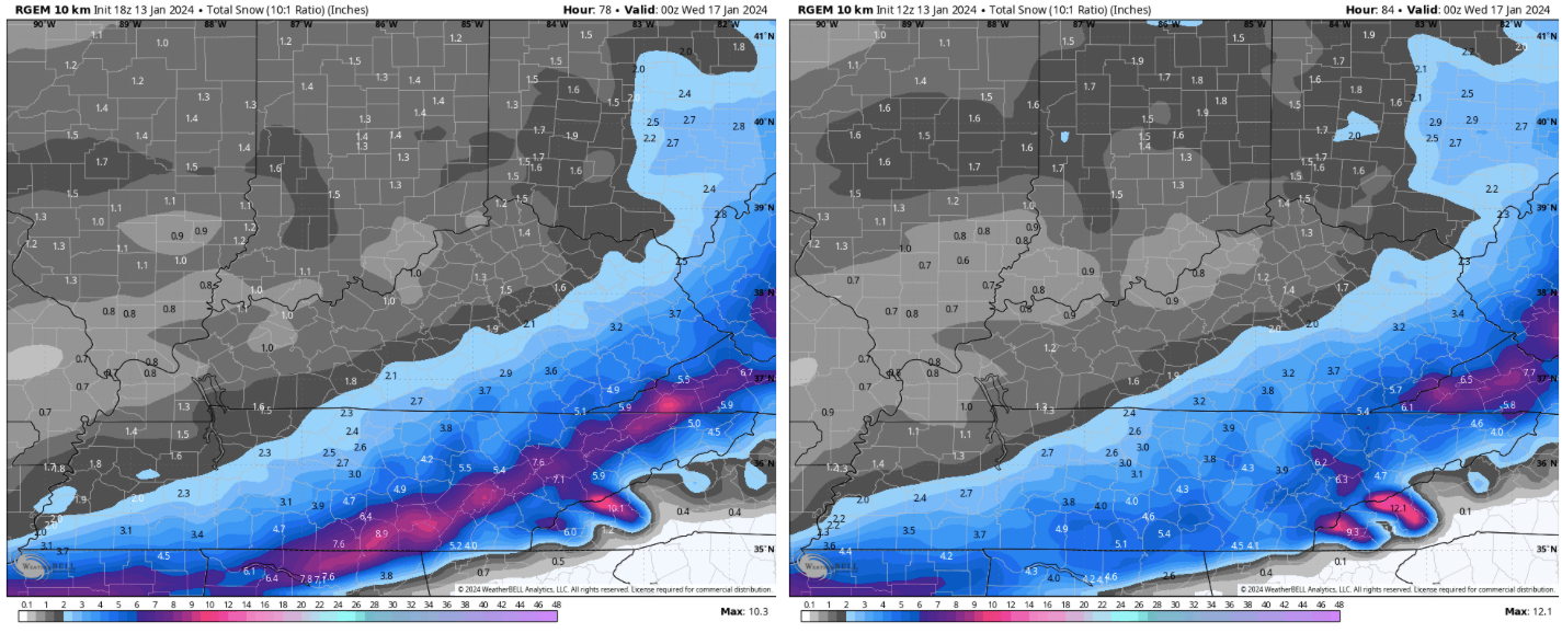
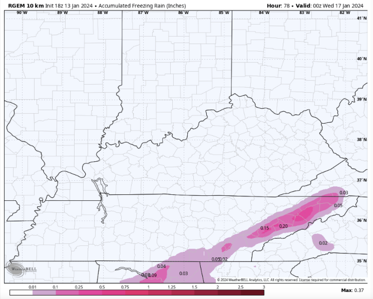
If this stays as is I like where I’m located.
.-
1
-
 1
1
-
 1
1
-
-
Look, I get it, I'm sorry for her. No matter what happens she is going to have a bunch of idiots messaging the WVLT studio, harassing her and her family. I suspect she is trying to temper expectations for viewers.
I don’t blame her at all. However one thing I believe that would help the local weather people in these situations is to show the viewers more than one solution and explain the difference. At this range they could show more than one accumulation map.
.-
4
-
-
Huge win for Tennessee
.-
1
-
-
She basically seems to be going with the NAM graphic and describing the snow to rain transition based on diurnal heating.
Time stamp is around 6 minutes in.
I never would have imagined we would have temp issues
. -
WVLT is riding with the NAM it looks like.


.-
 1
1
-
-
GFS
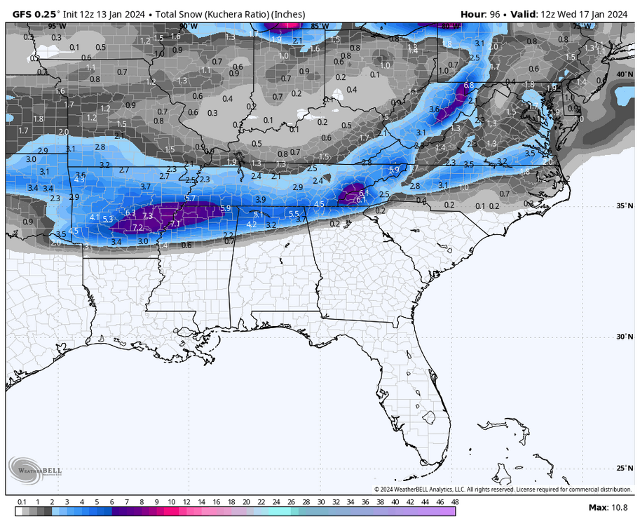
I didn’t look at the temps but I’m guessing the GFS thinks the front is ahead of schedule?
. -
I showed my wife all the mods. She picked the 3k NAM would probably be right. I’m packing her bags now.
.-
2
-
9
-
-
Also… im not sure it’s gonna make it to the low 40’s today. It’s 30.8 at my house.
.-
2
-
-
My buddy in Jackson is saying Memphis NWS thinks this is interstate 40 and south. Tells me they don’t like the NAM.
. -
Update from MRX…

.-
3
-
-
The HRW mods… don’t they have a NAM influence to them? They are much further SE than the NAM. More in line with the RGEM.
.-
1
-

January 15th-17th 2024 Arctic Blast/Snow Event
in Tennessee Valley
Posted
There could be some PType issues there but that was before the NAM just ran. All of that might have just changed.
.