janetjanet998
-
Posts
6,027 -
Joined
-
Last visited
Content Type
Profiles
Blogs
Forums
American Weather
Media Demo
Store
Gallery
Everything posted by janetjanet998
-
January 30-February 1 Winter Storm Part 2
janetjanet998 replied to Hoosier's topic in Lakes/Ohio Valley
Temp Has risen to 35 here with moderate to heavy rain -
January 30-February 1 Winter Storm Part 2
janetjanet998 replied to Hoosier's topic in Lakes/Ohio Valley
NAM has wrap around going until after 00z tomorrow for NE IL enjoy your 28 hours of snow -
January 30-February 1 Winter Storm Part 2
janetjanet998 replied to Hoosier's topic in Lakes/Ohio Valley
light rain here now 35 at airport at 18z but dew of 25 30-35 dBZ suddenly developing south of me near lincoln snow/sleet aloft? -
Feb 3rd - 5th Potential strong stm threat
janetjanet998 replied to Brian D's topic in Lakes/Ohio Valley
18z gfs weak and south but snow for IL and IND -
NAM also has lake enhanced convergence stuff ongoing into sunday evening for Chicago Metro 1/3 to 1/2 inch per hour rates at times
-
Feb 3rd - 5th Potential strong stm threat
janetjanet998 replied to Brian D's topic in Lakes/Ohio Valley
looks like 12z GEFS mean is around MLI then to just NW of MKE a couple members SE of that since it seems N IL gets more snow around this time on them -
ILX update warmer ISSUED AT 1046 AM CST FRI JAN 29 2021 EARLY ANALYSIS FOR THE WEEKEND SYSTEM DEPICTS PERHAPS SLIGHTLY WARMER TEMPERATURES JUST ABOVE THE SURFACE TIED TO A 40-50 KT 850 MB JET NOSING UP ALONG THE MISSISSIPPI RIVER. WILL EVALUATE FURTHER, BUT THIS MAY REQUIRE SOME ADJUSTMENTS IN SNOW TOTALS.
-
I think I made a post yesterday about how the GFS run increased precip in central IL(max for the system at the time) but decreased it across northern IL on one run suggesting convection may be robbing some of the moisture transport for at least a little while perhaps the NAM also is hinting at it now??? time will tell
-
I am not sure how much todays models factor that in but back in the day they always underestimated that I recall a storm back in April 1998ish when the rain/snow line stalled because of convection and the northern part of Peoria county got a surprise foot and the southern only a couple inches
-
18z GFS continues the wetter trend in the wettest areas central IL has about .30 more then 12z but northern IL .08 or so less perhaps this may be from more convection in the central part of the state zapping a fraction of the northern moisture transport? or perhaps just noise
-
18z NAM N IL I-80 destruction seems to be even wetter
-
spot the Jan 26-28th IL screw hole
-
LOL at 12z PARA for us such a waste of 1.4 inches of precip
-
ICON nudged north a tad and still changes snow to rain well north 995 low just WSW of Quincy 06z Sunday similar to NAM position but 2-3 mb deeper
-
looks like 700 mb wrap around action with lake enhancement at the end of the run at 84 hours like last system 20-25 dbz still along the IL lake shore .might be good for another 1-2 inches beyond NAM range
-
Winter 2020-21 Medium/Long Range Discussion
janetjanet998 replied to Hoosier's topic in Lakes/Ohio Valley
the 00Z GFS and 00Z CMC are almost 180 each other at 240 hours Canadian has a strong trough out west (988 low over Vegas) and what looks like a strong system getting ready to move east GFS has a cold air dump east USA and and high pressure out west(1018mb at Las vegas same time ) -
looks like the GEFS mean precip increased for us some since 18z
-
WTF is wrong with it lately? perhaps they should start re compiling the AVN model from 2001 instead LOL
-
Winter 2020/2021 Short Range Discussion
janetjanet998 replied to Chicago Storm's topic in Lakes/Ohio Valley
2 inches reported in Springfield IL area and still moderate snow band of 2-3 inches will likely fall across central and southern IL into IND..as well of back into MO A snow cover hole from parts of eastern IL into Northern IND should be visible on satellite tomorrow comical -
Winter 2020/2021 Short Range Discussion
janetjanet998 replied to Chicago Storm's topic in Lakes/Ohio Valley
not bad SPRINGFIELD SNOW 26 23 88 N10 30.34S VSB 1/4 WCI 16 DECATUR SNOW 27 26 96 NE12 30.31S VSB 1/2 MATTOON HVY SNOW 27 25 92 N17 30.26R VSB 1/4 -
Jan 25-26th Potential Something Part 3
janetjanet998 replied to Chicago Storm's topic in Lakes/Ohio Valley
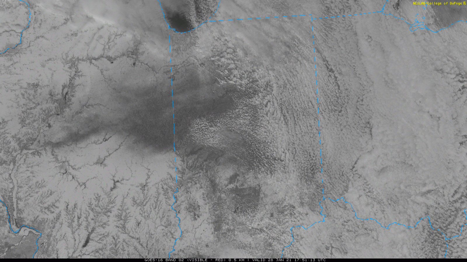
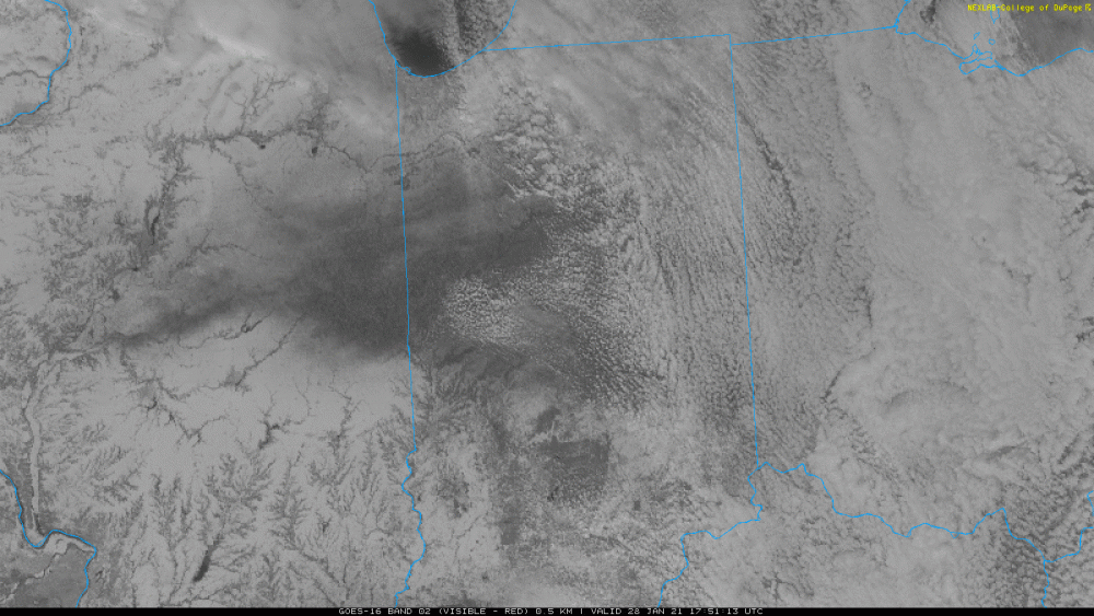
the band is looking a little better but for some reason the echoes weaken as they approach the shore also there is an east push noticeable off Lake county IL now central Cook county may have missed the window -
Winter 2020-21 Medium/Long Range Discussion
janetjanet998 replied to Hoosier's topic in Lakes/Ohio Valley
per EURO DSM snowiest season is 72 inches in 1911-12 they sit at 42 inches here today on Jan 27th just sayin' -
Jan 25-26th Potential Something Part 3
janetjanet998 replied to Chicago Storm's topic in Lakes/Ohio Valley
New winter product keeps LES advisory going new LOT Aviation update OR THE 18Z TAFS... THE PRIMARY FORECAST CONCERN THROUGH THE NEXT 24-30 HOURS REVOLVES AROUND A PENCIL-THIN BAND OF LAKE EFFECT SNOW TAKING AIM AT MDW AND EVENTUALLY GYY. OTHERWISE, GENERALLY QUIET CONDITIONS ARE EXPECTED. THE AFOREMENTIONED PENCIL-THIN BAND OF LAKE EFFECT SNOW IS CURRENTLY ENTERING NORTHEASTERN ILLINOIS JUST NORTH OF DOWNTOWN CHICAGO, AND HAS SHOWN RECENT SIGNS OF INTENSIFICATION WITH POCKETS OF RADAR REFLECTIVITY VALUES NOW APPROACHING 25-30 DBZ. SUCH VALUES WOULD CORRESPOND TO VISIBILITY DROPS AS LOW AS 1 MILE (IF NOT A SMIDGE LOWER). THE EYE TEST SUGGESTS THE BAND WILL LIKELY GET WITHIN A 5 MILE RADIUS OF MDW, BUT PERHAPS STAY A SLIVER EAST OF THE ACTUAL AIRFIELD. HOWEVER, LITTLE WIGGLES WESTWARD MAY AFFORD BRIEF DROPS IN VISIBILITY TO A MILE. THE BAND IS EXPECTED TO DRIFT EASTWARD LATER THIS AFTERNOON TOWARD GYY, AND EVENTUALLY FURTHER EAST INTO NORTHWESTERN INDIANA. ALL IN ALL, THE INHERITED TEMPO GROUP REMAINS APPROPRIATE WITH ONLY MINOR ADJUSTMENTS TO TIMING REQUIRED. AT ORD, THE POTENTIAL FOR THE BAND TO SWING WEST IS VERY LOW. EVEN SO, OCCASIONAL SPITS OF FLURRIES CAN'T BE RULED OUT THROUGH EARLY AFTERNOON. -
only .35 for you or so has some real clunkers for total precip also note that 5 out of the 20 on COD show no or very little snow over IA and N IL
-
Winter 2020/2021 Short Range Discussion
janetjanet998 replied to Chicago Storm's topic in Lakes/Ohio Valley
as of Midnight PIA officially had 7.1 this season(exactly 50% to date after today is factored in ) and you 6.1 you could pass us up today