

BornAgain13
-
Posts
2,879 -
Joined
-
Last visited
Content Type
Profiles
Blogs
Forums
American Weather
Media Demo
Store
Gallery
Posts posted by BornAgain13
-
-
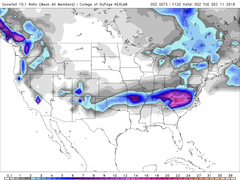
Is it just me, or does the NAM look like a disorganized system compared to the Globals?
-
Does anyone have the snowmap for the 0z EPS Mean?
-
1 minute ago, wncsnow said:
We need a more expansive precip shield on the north side of the storm. Out totals are dropped from 18 to 12 to under 8 now on the Euro..
Yeah, hopefully it will nudge back north some
-
 1
1
-
 1
1
-
-
1 minute ago, griteater said:
06z Euro ticked south again at 500mb. Classic slider look. And it's bringing the backside wave in better as well. The thing I can shake here are the mid level temperatures. One would argue that the models will correct as we get closer and show more cooling on the NW side of the 850mb low track as strong ascent offsets warm advection...that's normally how it works...but which one wins the battle, the strong dynamics and cooling that are almost certain to be there, vs. the marginal cold pre-storm airmass.
On the topic of the mid-level drying in the soundings, if you look at relative humidity charts at the 500-600mb levels, you can see the drying (dry slot) working in, but it's obviously after a strong thump on the front side of the storm (think heavy rates). I will also say that the precip is almost certain to be expanded farther north than what the current QPF shows, especially given how this is going to get wound up into a comma head....so, still looks good to me in SW VA for example.
If you keep saying the Euro ticks south each time you do a PBP, it's going to tick all the snow down into Florida lol
-
 2
2
-
1
-
-
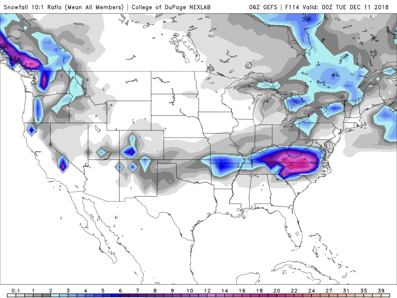
0z Run
06z Run
-
1
-
 1
1
-
1
-
-
06z GEFS looks like it increased in Northern NC and Southern VA
-
From what I see, the latest trends have a sharp cutoff on the N & NW side of this storm. Starting to look more and more southern VA is near the fringed line. Will this be more expansive than what the models are Depicting?
-
I appreciate y'alls PbP's!!
-
2 minutes ago, wncsnow said:
Never thought it could possibly trend too far.. south? Starting to look like less precip up into VA with more suppression but still a lot of time to go. About time for late NW adjustments
I wouldn't worry to much about that man... your location is in a very good spot.
-
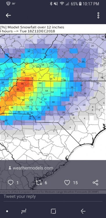
This is Really Impressive. From the 18z EURO Ensembles.
-
1
-
-
7 minutes ago, Queencitywx said:
12z UKMET: Crushed.
Just wow!!
-
5 minutes ago, Queencitywx said:
6z GEFS Snow means for Chapel Hill:
Down to zero whiffs.
7/20 show single digits but nothing below 3"
4/20 show 10-12"
9/20 show 12"+
Of those 9, 3 show 20"+
What is the GEFS mean for Dry Fork, VA?
-
8 minutes ago, PackGrad05 said:
To me, the maps look better and more expansive.
What don't you like? The lower totals overall? More realistic I think. There WILL be mixing with this storm.
I didn't stay up so I'm just basing this on what I see this morning.
I guess I didnt like the fact of the Euro and EPS taking that north trend, but maybe it wont have much affect on us? Truthfully, maybe it's just riding the coast.
-
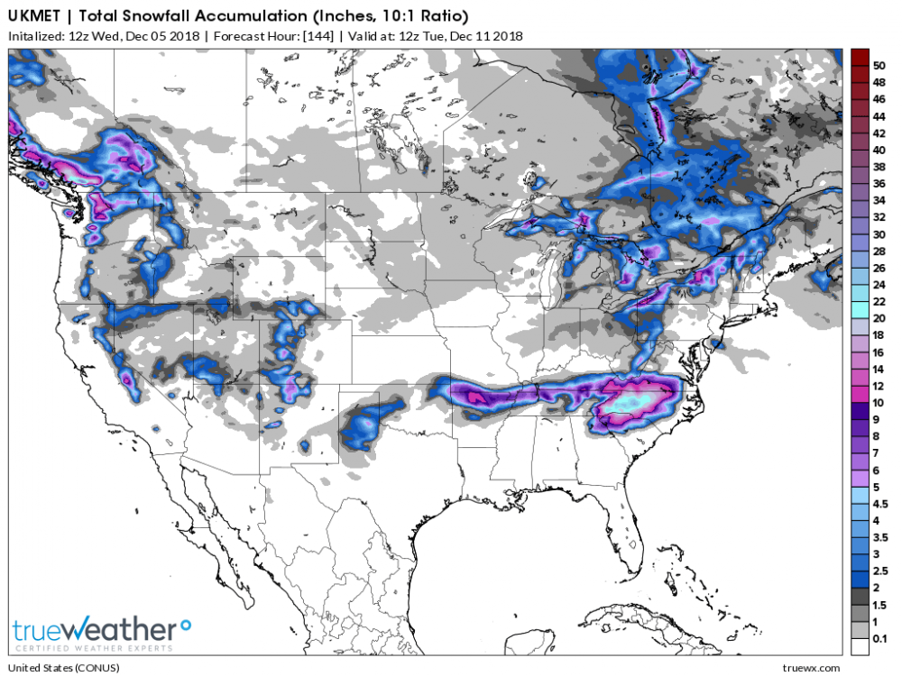
2 minutes ago, Poimen said:
Stole this EPS map from the MA forum.
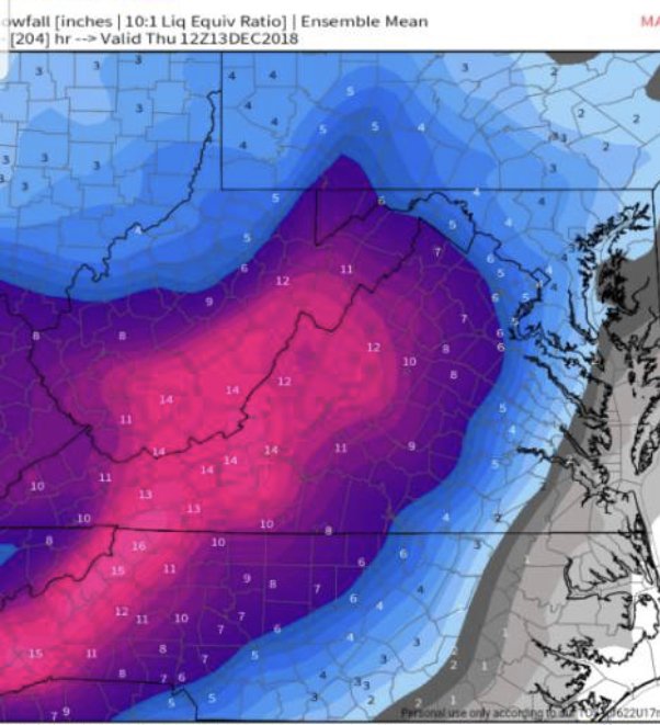
Still looks like about a 10" Mean for MBY. Dont like the trend of the Euro and EPS overnight though...
-
Just that short amount of time from 0z to 6z continues to show me that models continue to fluctuate....
-
6z GFS says... 0z was a hiccup, I'm back to showing monster totals!
-
Well, these overnight runs definitely did not trend well at all.....
-
FV3-GFS looks unreal... wow. Still snowing hard at 126
-
How's the Deep Thunder Model looking?
-
Does anyone know what the snow ratios will be in southern va? Maybe 9:1-10:1?
-
Kinda crazy after that weird run and I still end up with around 20" lol... this storm has so much moisture.
-
Can someone tell me when the snow begins in Dry Fork, VA? Is it Saturday night, Sunday Morning...?
-
1 minute ago, wncsnow said:
Interesting developments with that northern stream energy coming down late.. Mountains could really see over 2 feet if it phases
If it phases, we could see 2 feet... and the mountains close to 3
-
3 minutes ago, Buddy1987 said:
Would I be fringed up here you think man with a track like that? I worry the dry air would inhibit from northern extent reaching me, as you know the dewpoints are gonna be dry as heck.
The track looked good but apparently the NW shield fringed you.


December 8-10, 2018 Winter Storm
in Southeastern States
Posted
I'm glad I was waiting till tonight to put out my snowtotals on social media!