

BornAgain13
-
Posts
2,879 -
Joined
-
Last visited
Content Type
Profiles
Blogs
Forums
American Weather
Media Demo
Store
Gallery
Posts posted by BornAgain13
-
-
Euro looks like it has another one coming in after next weekend.
-
4 minutes ago, Queencitywx said:
Starts off with warning ice accretion followed by heavy snow with temps around 20 followed by lows near zero.
Wow!!
-
15 minutes ago, hickory said:
Quick question. Why would they issue a Winter storm warning, instead of a Ice storm warning for the triad. Doesnt 1/4 of ice meet criteria? Thanks
They no longer longer use Ice Storm Warnings anymore in this part of the Country.
-
 1
1
-
-
-
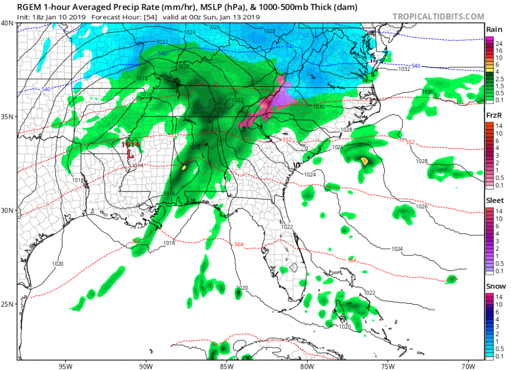
Ummm.. the latest RGEM on the ICE = lights out.

-
 1
1
-
-
7 minutes ago, griteater said:
18z Euro bumped up with precip overall and has solid amounts thru our forum (though not hefty). Temps were similar, maybe just a touch warmer. For GSP-CLT-RDU, the Euro has high temps around 40 degrees on Saturday with dewpoints from 20-25...during the height of the precip, the temps hover around 34 degrees.

@griteaterCan you show the Snow and Ice map from the 18z Euro?
-
I'm also surprised that WINTER STORM WATCHES have not been issued yet.
-
I know it's the Rgem but it looks healthy at 54.
-
Does anyone think this will be a situation in which Northern NC and Southern VA get placed under an ICE Storm Warning?
-
Is this thing possibly picking up on the stronger high and maybe getting colder than modeled.
-
12 minutes ago, Thor said:
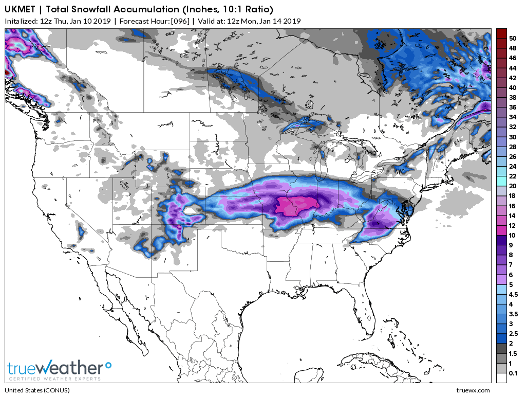
UkMet

Pretty impressive... that's a good snow but the UK probably includes sleet to right ?
-
2 minutes ago, NCSNOW said:
FV3 has definitely trended more icier and colder at 12z compared to its earlier runs. ICON would be a big ice storm in NC, Just like the Canadian if you look t surface temps,DP ,Precip.
Trended way colder... hmmm
-
1 minute ago, FallsLake said:
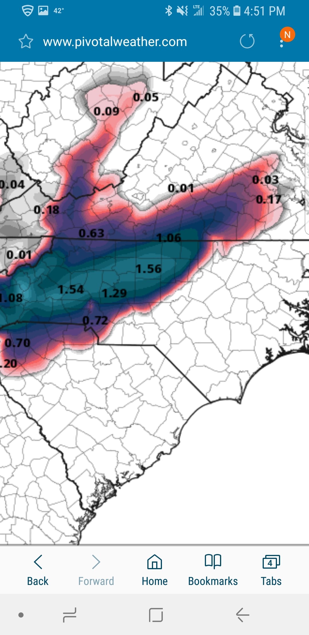
CMC looks to hold it's ground for a major ice storm for up state to Charlotte to Raleigh. It anything it's a little colder at the surface than the past run. **first time it's trended back colder
The High placement looks good and solid.... it's a colder run for sure.
-
5 minutes ago, kvegas-wx said:
Curious, what forecaster or station covers your area? Someone in Danville or the Triad stations? You are about 40 miles north of GSO, plus some elevation. So this event could certainly be quite different for you vs N NC and the piedmont.
ABC 13 out of Lynchburg
-
One of the experts like @griteater or someone else can help here... I noticed one of the locals here suggesting we get more snow than what is modeled ... his reasoning is because of how far south the cold dry air will be and the evaporational cooling... he said the models dont take that into effect... just curious yalls opinion... hes a great meterologist... and he says he is confident.
-
2 minutes ago, mackerel_sky said:
Gfs wasn’t North. Has the low going S of ATL
Must be lack of high pressure?
-
0z GFS and 0z Canadian both move north.... next
-
The NAM is a mess...
-
Yeah, I hate to say it but this one is trending in the wrong direction if you want snow/Ice
-
4 minutes ago, griteater said:
New Euro

Are you leaning more with what the Eiro is displaying over other guidance grit?
-
Mid-Atlantic forum will like this run... looks nothing like the UK... which is weird.
-
Yep, this Euro run is way warmer at 850's! Booooo!!
-
1 minute ago, Disc said:
He is copying a link that you need to be logged into to see the attachment. Here is the map.

Thanks
-
Looks like the Euro is going to be to far north....


January 12-13th Winter Storm Obs
in Southeastern States
Posted
32/24 , with the ground already white from the first batch of snow.