

BornAgain13
-
Posts
2,879 -
Joined
-
Last visited
Content Type
Profiles
Blogs
Forums
American Weather
Media Demo
Store
Gallery
Posts posted by BornAgain13
-
-
2 minutes ago, Queencitywx said:
This was a pretty decent run for the N&W parts of the triangle for early next week
Euro puts down 1-2" from the frontal passage...
-
GFS trying to get something going next weekend....
-
Just now, SouthCentralWakeCo said:
Correct
CMC brings the weekend storm as well but it's mostly rain...
-
CMC looks better than GFS I believe...
-
1 minute ago, CaryWx said:
Getting a little snow in central NC on the 30th
It actually looked better on the precip panel than what turned out on the snow map...
-
3 minutes ago, CaryWx said:
Fropa snow rising on the GFS--we'll see here shortly
Much better run on the GFS with the Frontal Passage Snow...
-
 1
1
-
-
ICON looks like it's got the storm next weekend.... coming up from the gulf.
-
45 minutes ago, DCTeacherman said:
EPS snow mean looks better at 18z compared to 12z for the Tuesday/wed deal.
Edit: to be specific the 24 hour snow map centered at 144 hours is 2-4 for the whole area as opposed to 12z when there was a stripe of 1-2 over dc and immediate area. Also the 4-6 line bumped south closer to the PA/MD border.
Have an 18z EPS snow map?
-
21 minutes ago, Bob Chill said:
Yea, way too far out in time to worry about run over run changes on ops. We have no idea how the arctic front wave is going to go let alone a d8-10 coastal. All we can say right now is we might get some snowfall with the front and there might be more chances down the line. Oh, and also the odds of the control run verifying are lower than the Redskins having a winning season next year.
I would go with the control run over the Redskins having a winning season...
(From a Cowboys Fan)

-
 2
2
-
-
12 minutes ago, BristowWx said:
Maybe if it was next Thursday. Way too early to lose sleep.
True lol
-
I guess we all have no choice but to stay up for 0z tonight lol
-
The cold is coming no doubt... man if some of these numbers next week are even close... brrrrr
-
Remember guys, even if a storm is showing up 8-10 days out, most of the time we think it's to far out... the early December storm was detected by models 8+ days out and kept it right on through... let's see if this holds or trends better... aren't u glad we at least have something to track? Frontal snow and possible a big one. 2 threats within 9-10 days.
-
Still snowing after that image.
-
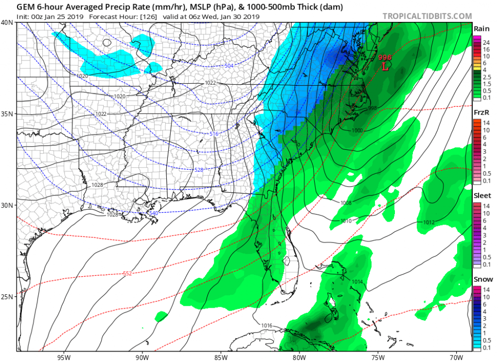
Control Run for next weekend
-
5
-
-
2 minutes ago, Ji said:
dude--the euro control is more wrong than the snow crazy ggem. Get your expecations in check

-
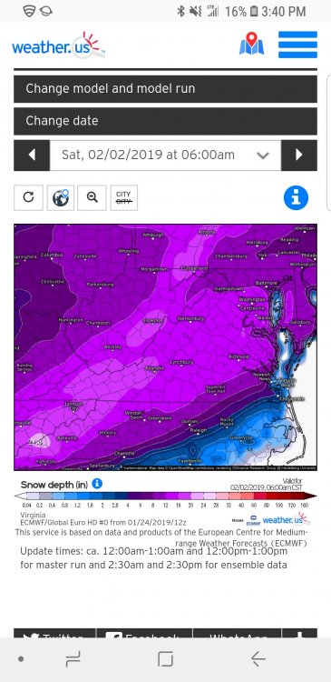
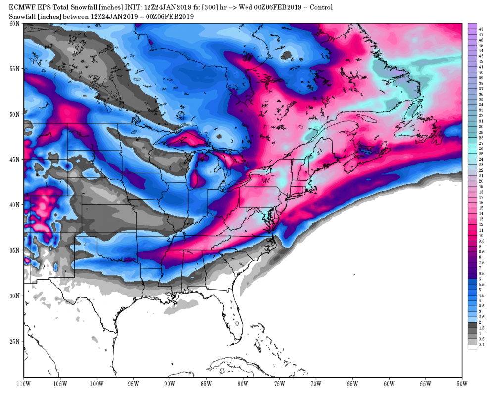
12z Euro Control Through Feb 6th

-
3
-
-
2 hours ago, CaryWx said:
l
Let's see if it's still there when the 12z rolls out
The 12z Control has it again, can't see yet if its snow or rain, but another run of a storm around Feb 1st-2nd
-
Just now, FallsLake said:
Here's the euro:
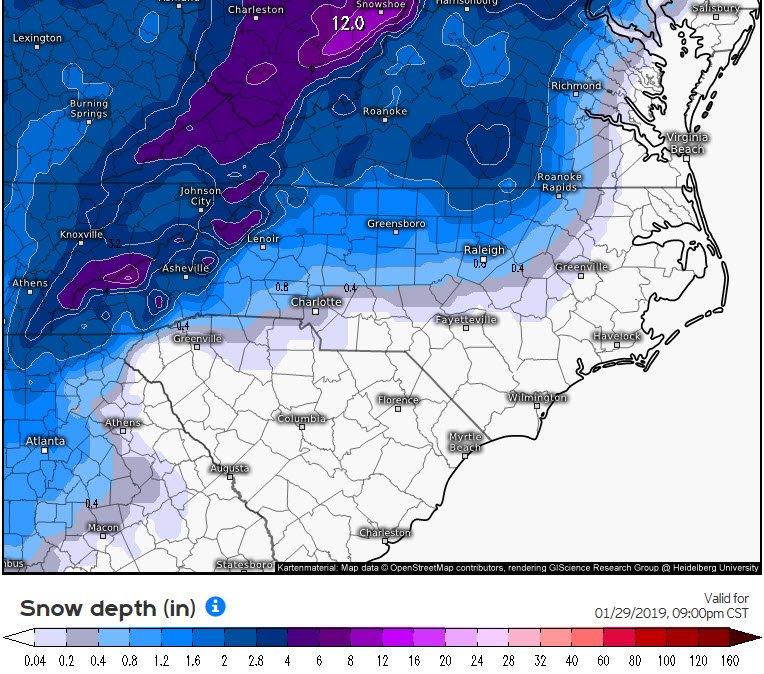
Brings around 2" to mby... I'll take it over the snow drought we've had since the December storm...
-
1
-
-
17 minutes ago, FallsLake said:
Nope, and the Canadian went down as well.
But on the positive side, the Canadian does have a nice storm showing in the 8/9 day range.............................................................................
The 0z EURO Control had something similar to the CMC around that time frame...
-
3 minutes ago, NCSNOW said:
Check out 18z canadian and fv3 for next Tues/Wed. Lot more easier to do than this tightrope phase we where hoping to pull off and still could enc espeacilly. But even there high odds still.
18z FV3 looks good for next week... can u post image of 18z Canadian??
-
The more I look at these model runs the more frustrating it gets.... 1-2" rainfalls, the dry and cold several days, then it warms up enough to give us another rain. Then it gets cold and dry again... a "Rinse & Repeat" pattern
-
1 minute ago, Queencitywx said:
Gonna be a decent euro run
Details... lol
-
Fv3-GFS 18z looks good for next weekend... would like to see more consistency.

Mid to Long Term Discussion 2019
in Southeastern States
Posted
Does look like a good run for the Carolinas.... right?