

BornAgain13
-
Posts
2,879 -
Joined
-
Last visited
Content Type
Profiles
Blogs
Forums
American Weather
Media Demo
Store
Gallery
Posts posted by BornAgain13
-
-
Still not enough cold air though...
-
Well guys , the GFS was giving some hope but the whole time the GFS gave hope , the EURO said take a hike... maybe we can get something towards the new year.
-
That run of the GFS was looking great until I looked at the surface and precip maps....
-
26 minutes ago, Orangeburgwx said:
6z GEFS

Sent from my A577VL using Tapatalk
Now that's a good sign!
-
Just now, HKY1894 said:
This map is classic look for an east coast winter storm. Ridge axis out west could move to the west a little maybe.
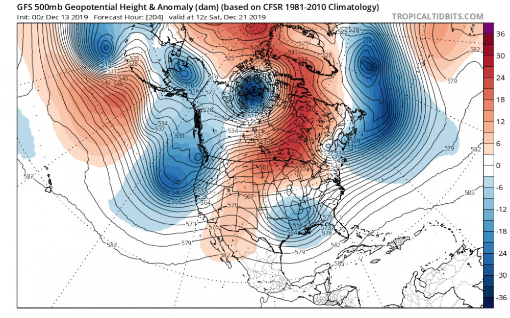
Definitely a classic look , I was watching that bowling ball move across the country as the GFS hrs was rolling in... check out that High Pressure position in Canada as well..
-
 1
1
-
-
Either the GFS is on to something , or the GFS is on something...
-
0Z GFS brings big snows to Central and southern VA and Northern NC with the storm next weekend... key right now is not the amounts but that the GFS has consistently shown a storm of some sorts... sure would be nice to see the EURO jump on board.
-
4 minutes ago, PackGrad05 said:
Can someone post the EPS ensemble members?
Don't think they are out yet...
-
3 minutes ago, ryan1234 said:
Hard to bet against the EURO, just saying. It could be on to something.
.Very possible, but as active as this pattern is , it's hard for me to believe not even a rain storm would happen later next week...
-
1
-
-
The 12z EURO is almost laughable compared to the other modeling... it barely has any precip in the US after early next weeks rain.
-
Looks like the 12z EURO is going to be dry with no storm for next weekend... complete opposite of the GFS
-
12z GFS still showing the storm next weekend... just doesnt have the cold air we need...
-
15 minutes ago, BIG FROSTY said:
00z RGEM I think has about 10 hours of ZR in my area. Mess or No it's about temps, 28-29 vs 31-32 BIG difference when you talking ZR.
Not saying it's not right , but I've seen the RGEM do this... and it be way off... Personally , I believe the RGEM is to cold with to much ZR
-
1
-
-
Central to Northern VA gets Hammered this run... would love to see soon the EURO and CMC start showing a storm.
-
Storm signal is still there on the 18z GFS for the Weekend before Christmas... little colder this time but need it to be colder... plenty of time to track
-
1
-
-
12z GFS still bringing a big storm of some sorts , SNOW/ICE/RAIN depending on location the weekend before Christmas.... still plenty of time to iron out the details of that possibility
-
Kinda surprising to see the GFS have a similar or close to outcome with that storm for 2 runs in a row... that time frame could be legit though if the blocking sets up
-
1
-
-
0Z CMC still very ICY , but definitely more realistic with totals this time!
-
Probably not accurate, but the 18z CMC continued the theme of a Bad Ice Storm , Central NC , Southern VA , Central VA
-
54 minutes ago, NorthHillsWx said:
I would agree with you there. Salem looks to be one area I'd flag as still having the potential for a significant event here. Just because it may be more localized and fewer posters on this forum will see much of anything, it does not mean some areas could receive a significant storm.
I'm in a similar situation as y'all. I'm in Dry Fork, VA...
-
Allan has pretty much given up on next weeks potential...
-
12z EURO still says , Here's your rain!
-
28 minutes ago, griteater said:
Yeah Mr Euro has gone away from the initial wave scenario, and the GFS moved to it this run (and trending that way on the ensemble mean)
The low budget models (JMA & NAVGEM) continue to like the more wintry early wave scenario as well
As much as I want to see a Wintry scenario, until the Euro is on board , it's hard to believe the GFS and the others...
-
1
-
-
Looks more like next weekend's system will set the stage for the following weekend possibly...

Mid to Long Term Discussion 2019
in Southeastern States
Posted
GFS trying to real us back in...