

BornAgain13
-
Posts
2,879 -
Joined
-
Last visited
Content Type
Profiles
Blogs
Forums
American Weather
Media Demo
Store
Gallery
Posts posted by BornAgain13
-
-
0z RGEM coming in now... let's see if it maintains the more moisture/ colder output...
-
1 minute ago, Buddy1987 said:
I honestly dont know what to really expect out of this storm. Part of me has set the bar a little too high but then the other part of me wonders does southeast flow, moisture transport and lift make this thing over perform and continue the precip longer than what the models are showing in some instances? I guess safe for our areas is maybe a 2-4 type ordeal, then .25 of ice. High end maybe 3-5 with 1-2 tenths of ice. Low end being 1-2'' of snow and sleet accumulation followed by a prolonged freezing drizzle ordeal. Idk what do you think?
For my area in Dry Fork northwest of Danville, I'm going with about 1" of Snow/Sleet, with up go 1/4" of ZR...
I would probably go with 2-3" for your location with the same ZR... hard to say. It could be more...
-
4 minutes ago, Buddy1987 said:
Front end thump is definitely noticeable and more in line with most guidance. Its finally getting a clue lol.
Yeah, although the 3k looks good and then it looks like it falls apart... 12k looks better
-
5 minutes ago, Blue_Ridge_Escarpment said:
Best run of the NAM yet if you like a lot of sleet and freezing rain.
Definitely had more moisture
-
 1
1
-
-
15 minutes ago, snowdude said:
Thank you!
-
18 minutes ago, snowdude said:
I'd say that's a pretty decent shift south and east.
12z and 18z below:

Can you show southern VA from this map?
-
1
-
-
5 minutes ago, PackGrad05 said:
18Z GFS was a little earlier with the arrival of the precip and maybe a touch colder?
Yes! Hopefully a trend.
-
3 minutes ago, PackGrad05 said:
When does the 18Z RGEM come out?
Already out on this site... still showing more moisture and colder air than others...
https://www.pivotalweather.com/model.php?m=rdps&p=sn10_acc&rh=2019021818&fh=48&r=us_ma&dpdt=&mc=
-
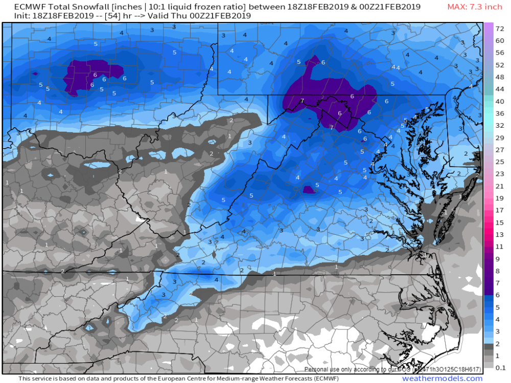
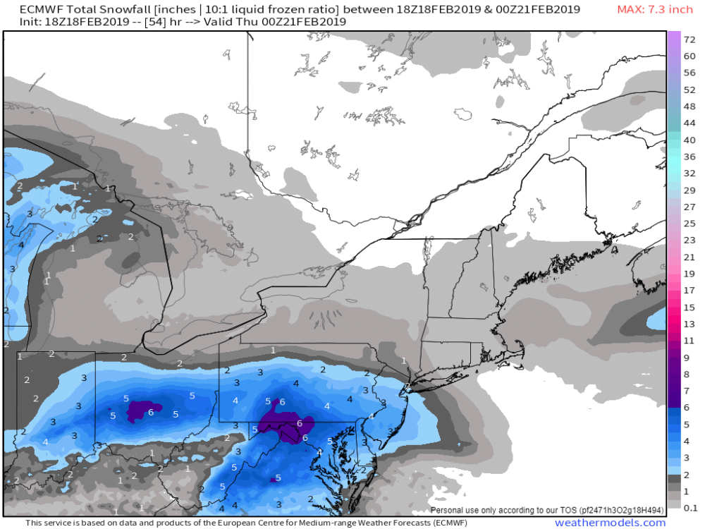
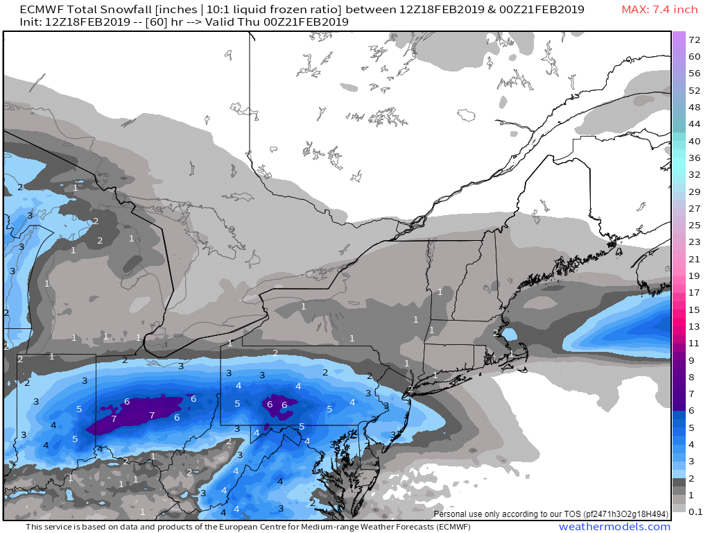
RGEM still holding on to the idea of more Moisture and colder air... shows more snow in southern and central va...
-
4 minutes ago, kvegas-wx said:
Blacksburg out with a more refined WSW for southern VA and western VA for up to 3" snow and sleet and a minor icing event. Sounds more reasonable but rates will have to overcome the warming of todays 60°.
Winter weather Advisory for Southside, just to the North are the Winter storm Warnings.
-
In this setup, this is what I would go with.
Southern VA - 1-2" Snow/ .10-.20 ZR
Central VA - 3-5" Snow/ up to 1/4" ZR
Northern VA - 6-9" Snow/ .10-.15 ZR
-
3 minutes ago, kvegas-wx said:
WSWatch up for southern and SW VA elevated areas. Just saw the post for stuart and it says "up to 7" of snow"...!! I'm going to assume that means the elevated areas of Patrick County and not Stuart proper. Anyone have a Bufkit for ROA that might show what elevation will see heavy snow?
Looks like that up to 7" includes everyone under the watch. As we get closer they will fine tune the details for different locations...
-
2 minutes ago, Solak said:
NWS RaleighVerified account @NWSRaleigh 14m14 minutes ago
Latest update regarding Tue Night -> Wednesday AM wintry mix. Forecast has trended slightly warmer, resulting in reduced icing and snow/sleet amounts. Still a few slick spots possible for your morning commute on Wednesday. Download latest
#NCwx brief: https://www.weather.gov/media/rah/briefing/NWSRaleighLatestBriefing.pdf …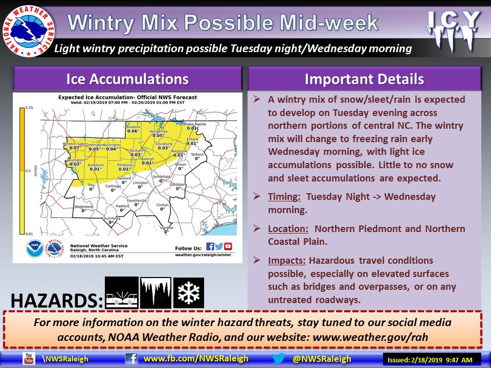
What is showing warmer?? Why would they lower amounts when models are trending colder...
-
The Canadian and RGEM have a lot more snow and ICE for my area than other models... I dont think they are right..
-
I wish the RGEM was correct, kinda worried , the NAM is to dry..
-
RGEM also looks good at the end of its run!
-
Kind of curious guys, this forum will no longer let me upload a photo no bigger than 30.72 KB... it used to would let me, but I can't even upload a simple TTidbit map.
-
-
NAM with a Major ICE Storm, Northern NC, Southern VA
-
The incoming NAM run looks like a good one....
-
1 hour ago, NorthArlington101 said:

Thank you!
-
1
-
-
7 minutes ago, psuhoffman said:
The snow depth on the 18z euro seems best in line with the qpf that falls when it’s snow looking at the 1 hour precip type and temps. DC flips to ice between 12-1pm. Northeast of Baltimore holds on another 2 hours or so.
This looks in line with the qpf that falls as snow

Any possible way you have a map that shows southern VA from the 18z Euro Snow Depth?
-
18z GEFS comes in colder and keeps the precip frozen a lot of the storm for northern nc, southern va
-
Alright @Queencitywx , how is the Euro looking? Similar to 0z?


Feb 19-20 Winter Storm Threat
in Southeastern States
Posted
Rgem sticking to its guns... colder and more moisture than other guidance with that front end thump.