

BornAgain13
-
Posts
2,879 -
Joined
-
Last visited
Content Type
Profiles
Blogs
Forums
American Weather
Media Demo
Store
Gallery
Posts posted by BornAgain13
-
-
Most guidance looks to be locking the cold air in longer..
-
2 minutes ago, nchighcountrywx said:
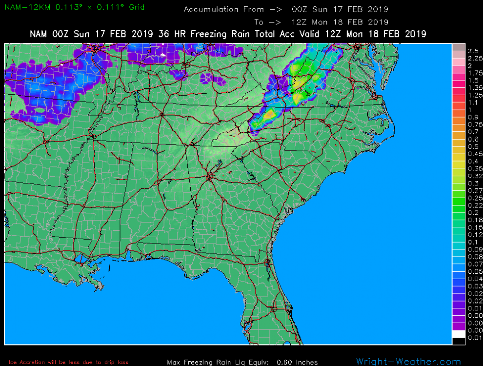
With more ICE coming after this image...
-
Any other way you guys can show the 18z GFS Ensemble mean to compare with 12z
-
13 minutes ago, CAD_Wedge_NC said:
double-click the link and let me know if it doesn't work.
Yeah, it doesnt show on my end...
-
7 minutes ago, CAD_Wedge_NC said:
Image isn't showing...
-
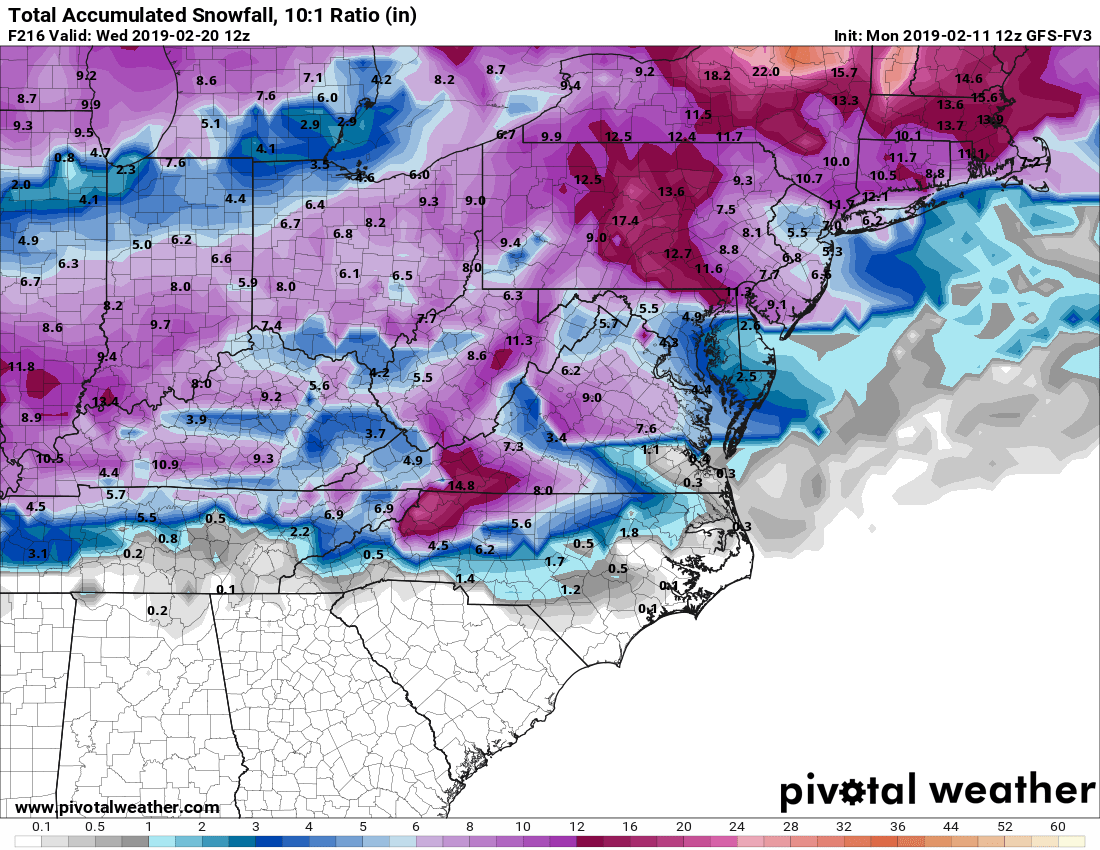
6 hours ago, Hvward said:
GEFS snowfall map on the increase.
6z
12z
.18z GEFS improved again to right?
-
5 minutes ago, Hvward said:
GEFS snowfall map on the increase.
6z
12z
.Starting to come back to what it was showing the other day maybe? We will see.
-
14 minutes ago, Hvward said:
Check out the soundings around KAVL on the 12z Euro. Small details but they will make a huge difference in WNC. A meso high develops in NNC and that allows a frozen column to be in place around 8pm Tuesday evening. To compare to the 0z Euro at 8pm Tuesday which had 4c at 850mb. The 12z is shown as 0c on weatherbell at KAVL at 8pm. That’s nearly a 7 degree F difference. With this much volatility, it’s hard to speak in any certainties, but yes the high pressure could come in higher than models are showing, and we could be seeing models realize that. Lots of options still on the table with accumulating snowfall being one of them for WNC Tuesday into Wednesday.
Excellent Post! Thank you!
-
 2
2
-
-
12z Euro is all rain outside the Mountains.
-
21 minutes ago, Hvward said:
This one is going to be a difficult one to forecast. Need the NAM 3km to get in range. Look like some sleet or ZR could be possible tomorrow night above 3500’ around Boone tomorrow night as well.
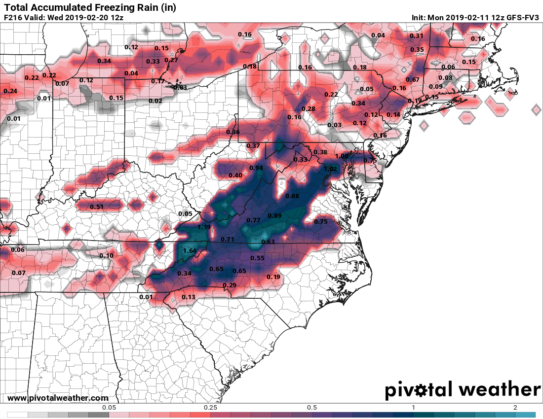
Is it possible the High can be stronger for the Tues/Wed system... the Euro and GFS have shown hints of it and the CMC today shows an ICE STORM in VA
-
23 minutes ago, FallsLake said:
12z GFS coming in a little colder. Looks like some mixed snow for N. NC up into VA. Maybe even a significant event for NW NC into VA.
Both GFS and CMC coming in Colder... a significant ICE STORM on the CMC, with maybe 1-4" of Snow in northern NC/Southern VA from GFS
-
57 minutes ago, Queencitywx said:
The sounding isn’t too far from isothermal on Tuesday Evening.
Tropical tidbits snowmap shows accumulating snow here but the surface maps just show rain... kind of weird.
-
That Is A Whole Lot Of Rain Being Output By The 18z GFS
-
8 minutes ago, Queencitywx said:
pretty strong signal

Strong Signal, as far as ICE STORM?
-
 1
1
-
-
CMC still a rain storm, GFS is a SNOW/ ICE to Rain, and then an ICE Storm after that...
-
2 hours ago, FallsLake said:
The euro is also in the same camp. Would be nice to see them come in colder at 12z.
Yeah, Its going to be tough to jump on board without the Euro!
-
57 minutes ago, Cheers for Western Ears said:
It is encouraging to continue to see support from both the GFS as well as the Fv3 (op runs that is) is the Euro still in agreement at all?
Euro mainly showing Rain right now...
-
37" in Alabama , according to 18z GFS lol
-
1
-
-
18z GFS has the storm again, and it looks like it's going to be a "Dream" Run for many...
-
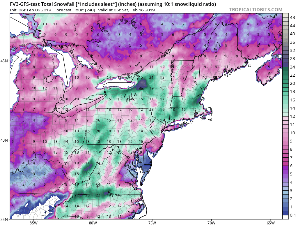
55 minutes ago, frazdaddy said:
FV3 toyed with it and another for the 21-22 at 6z. So we have hints from the Euro, Fv3, GFS and the Canadian that something could be up around the 20/21 timeframe.
We shall see.
12z FV3 Continues the theme...


-
0z GFS pressing the CAD down a little stronger this time...
-
41 minutes ago, wncsnow said:
Winter is on its dying breath folks, enjoy the 80's tomorrow. It does look to get wet again next week and nasty cold rain likely for escarpment areas..
Hey, stop busting bubbles around here! lol
-
19 minutes ago, FallsLake said:
Bummer, I'm in the snow hole and only get 12".....

It did lead the way for the December storm. I would really like to see more model agreement. GFS is trying but still not there. Lets see what the 12z runs bring.
Would love to see the Euro get on board but it's way to far north...
-
Lol at the FV3....


Mid to Long Term Discussion 2019
in Southeastern States
Posted
GEFS as Well... GEFS has a Strong CAD Signature