

BornAgain13
-
Posts
2,879 -
Joined
-
Last visited
Content Type
Profiles
Blogs
Forums
American Weather
Media Demo
Store
Gallery
Posts posted by BornAgain13
-
-
As bad of a run as that was compared to previous runs, still about 9" IMBY taken Verbatim.
-
1 minute ago, NCSNOW said:
Waiting on the clown map pastebombs tonight, showing everything painted 12÷ south of Mt Airy, BIG FROSTY. He'll be shaded in the dusting color all the way up to the start of the event. Then when we post final storm obs he'll have 19 and rest of us will be talking about what almost was.
Maybe someone will get a 25" paste from the 0z GFS!
-
Alright, who's doing play by play for 0z GFS and 0z CMC?
-
Anybody have the 18z GEFS ensemble mean for snow for Dry Fork, VA?
-
Just a guess. But I'm thinking the 18z GFS will come in further south as well.... it just seems like that High Pressure will block it from coming to far north.
-
Should be interesting to see what DT says about how the Euro model abandoned him... lol
-
Just now, Buddy1987 said:
I’m guessing a little more bc of ratios with the temps that cold. I believe last I looked they were running in the low to mid 20s. Face value it’d be a solid storm and I would take it in a heartbeat if it’s gonna be squish city.
Yeah, other than the Ensembles, the Euro and the Control run both are to fall south for my area... kinda weird to say that, but those show squash city. Which is good for a lot of the forum. Just not myself.
-
1 minute ago, griteater said:
0.75 - 1.00 liquid
Thank you! I'm guessing that's around 9-10" of snow?
-
21 minutes ago, griteater said:
EPS Mean coming in shifted south like the Op, and colder. Sfc low runs from Brownsville to south of Louisiana and over to off Jacksonville with strong damming high to the north moving in tandem. Wave looks better (more consolidated and clean - less strung out). Blocking trough over the NE looks good. This is a killer setup overall on the EPS, no doubt about it.
What does the 12z EPS show for southern VA this run?
-
4 minutes ago, Orangeburgwx said:
Is that the master?
Yes, the Control and Ensembles will be out soon. Very impressive run for Southern NC and Upper SC
-
8 minutes ago, griteater said:
EPS Mean is slightly weaker with the wave and sfc low compared to its last run. Still plenty of precip, but the overall precip output shifted south with the totals (a good thing in my mind from a temperature standpoint). Sfc low track is similar and it's a slightly colder at the sfc. 32deg contour on the mean runs roughly from Burlington to Charlotte to Spartanburg as the bulk of the precip rolls thru.
The GEFS and EPS Means tonight both moved a little south and a little colder thru our forum areas.
Grit, how does the EPS mean look for Dry Fork, VA?
-
For MBY, that would be like 8-10" of Snow, then .50+ of freezing rain... uhhh.. leave the ice out.
-
 1
1
-
-
This is a big run for the Mid Atlantic Forum.
-
I know we are still far out folks, but what is almost certain is, that their will be a storm. Nailing down the specifics will be interesting as we get closer.
-
How does the GFS keep insisting that the Low goes right into that High?
-
1 minute ago, Queencitywx said:
EPS means went way up. For example, Burlington went from 1.6” to 4”.
What is the EPS mean now showing for Dry Fork, VA. I can see the individual members but not the mean.
-
I counted about 38 out of 50 members with a Moderate-Major Snow for my area in Dry, Fork.
-
1 minute ago, Thor said:
Wow!
-
6 minutes ago, CADEffect said:
pic?
I could show something but the main take away is the GEFS is consistent at staying much further south than the OP.
Here's the 12z GEFS Snow Depth.
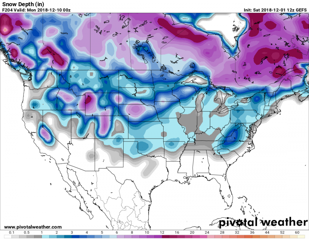
-
12z GEFS still different from the OP. Widespread Winter Storm.
-
1
-
-
Just now, griteater said:
12z CMC is a big winter storm for our sub forum
Awesome!!
-
06z GEFS Mean Definitely went up.
-
1
-
-
I counted about 26 EPS members that had a moderate-major snowfall for my area. That's a lot. Still far out, but I like that the Ensembles show that...
-
2
-
-
I think we are still looking good folks....

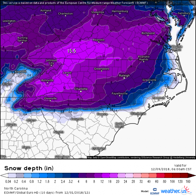
December 8-10, 2018 Winter Storm
in Southeastern States
Posted
The 0z EURO should be interesting!!