

BornAgain13
-
Posts
4,468 -
Joined
-
Last visited
Content Type
Profiles
Blogs
Forums
American Weather
Media Demo
Store
Gallery
Everything posted by BornAgain13
-

The “I bring the mojo” Jan 30-Feb 1 potential winter storm
BornAgain13 replied to lilj4425's topic in Southeastern States
0z GEFS.thumb.png.56883b2b68f502ded331c5e13edcf18b.png)
-
The “I bring the mojo” Jan 30-Feb 1 potential winter storm
BornAgain13 replied to lilj4425's topic in Southeastern States
This is really gonna make me stay up for the Euro... -
The “I bring the mojo” Jan 30-Feb 1 potential winter storm
BornAgain13 replied to lilj4425's topic in Southeastern States
0z GEFS much improved over 18z -
The “I bring the mojo” Jan 30-Feb 1 potential winter storm
BornAgain13 replied to lilj4425's topic in Southeastern States
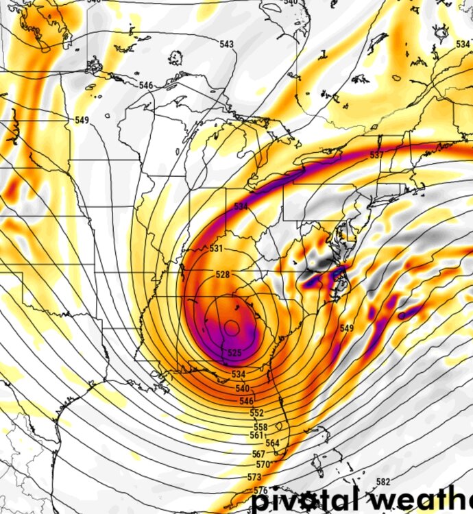
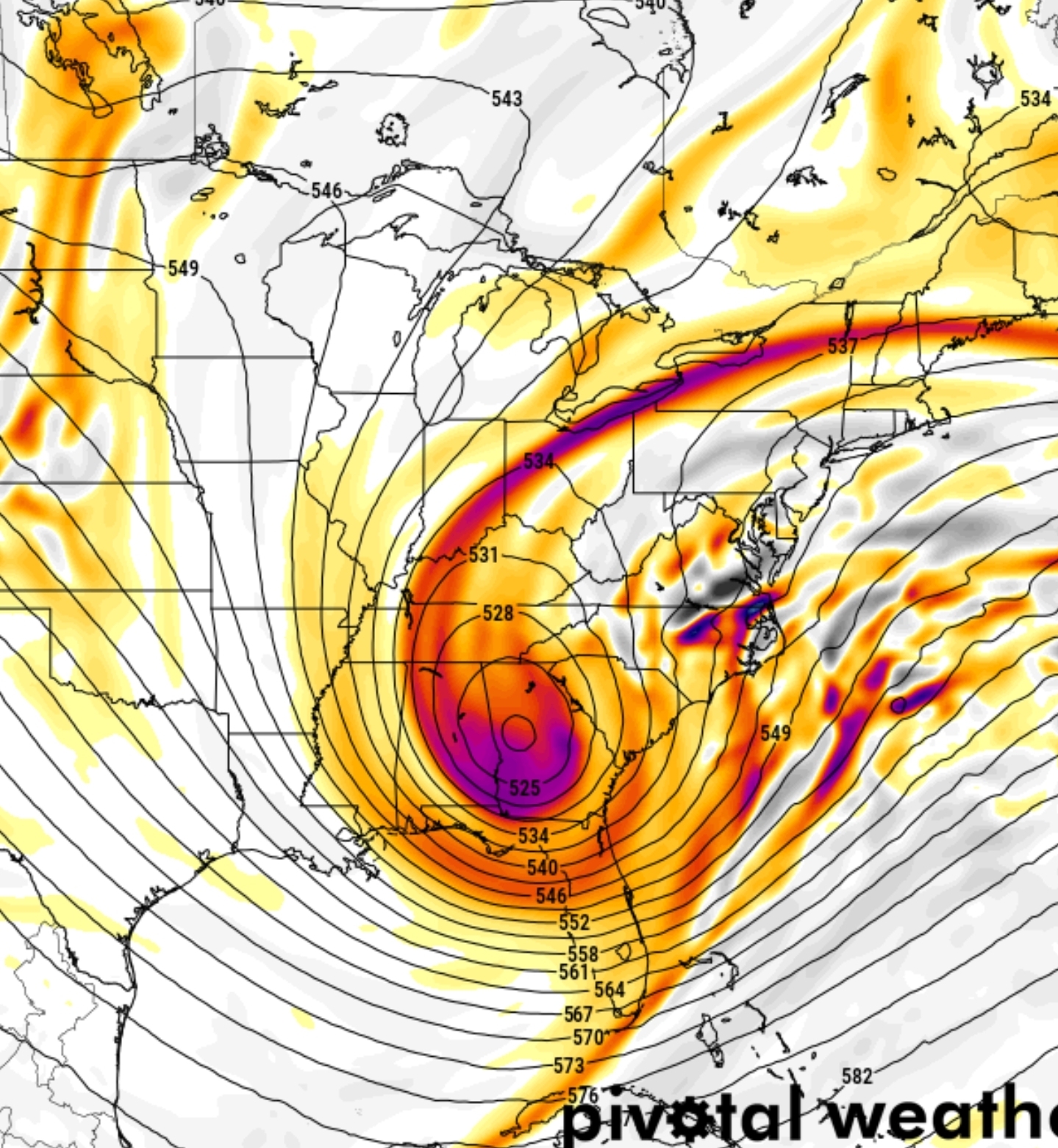
Kuchera.thumb.png.fe889df27cb5fa140cb82751a16bdfb7.png)
-
The “I bring the mojo” Jan 30-Feb 1 potential winter storm
BornAgain13 replied to lilj4425's topic in Southeastern States
Paste Job on the UK for North Carolina and Southern and SE VA. 2'+ -
DT is their. Not happening lol
-
The “I bring the mojo” Jan 30-Feb 1 potential winter storm
BornAgain13 replied to lilj4425's topic in Southeastern States
CMC shows "what could be." -
The “I bring the mojo” Jan 30-Feb 1 potential winter storm
BornAgain13 replied to lilj4425's topic in Southeastern States
1-3' in a lot of areas..thumb.png.4122e5a1e7ef44a3c218428fdc0f075b.png)
-
The “I bring the mojo” Jan 30-Feb 1 potential winter storm
BornAgain13 replied to lilj4425's topic in Southeastern States
-
The “I bring the mojo” Jan 30-Feb 1 potential winter storm
BornAgain13 replied to lilj4425's topic in Southeastern States
Negative at 120! -
The “I bring the mojo” Jan 30-Feb 1 potential winter storm
BornAgain13 replied to lilj4425's topic in Southeastern States
Negative Tilt on CMC . Monster Snow Storm! -
The “I bring the mojo” Jan 30-Feb 1 potential winter storm
BornAgain13 replied to lilj4425's topic in Southeastern States
CMC is a Big Hit! -
The “I bring the mojo” Jan 30-Feb 1 potential winter storm
BornAgain13 replied to lilj4425's topic in Southeastern States
0z GFS.thumb.png.7ff194988628ed3fee3f41dfe2b5c96d.png)
-
The “I bring the mojo” Jan 30-Feb 1 potential winter storm
BornAgain13 replied to lilj4425's topic in Southeastern States
Edit... GFS letting it rip now... especially in the Carolinas. -
The “I bring the mojo” Jan 30-Feb 1 potential winter storm
BornAgain13 replied to lilj4425's topic in Southeastern States
0z GFS is gonna be better than 18z. Not a big hit but hopefully a step in the right direction. -
The “I bring the mojo” Jan 30-Feb 1 potential winter storm
BornAgain13 replied to lilj4425's topic in Southeastern States
Icon is a complete whiff. -
The “I bring the mojo” Jan 30-Feb 1 potential winter storm
BornAgain13 replied to lilj4425's topic in Southeastern States
This is how I feel about the models tonight
-
The “I bring the mojo” Jan 30-Feb 1 potential winter storm
BornAgain13 replied to lilj4425's topic in Southeastern States
I could be wrong but at the end of the NAM, it looked like it was about to go BOOM -
The “I bring the mojo” Jan 30-Feb 1 potential winter storm
BornAgain13 replied to lilj4425's topic in Southeastern States
Are u buying that and the Euro more than what the GFS shows? I know its still early but I know its a good thing if you are optimistic -
The “I bring the mojo” Jan 30-Feb 1 potential winter storm
BornAgain13 replied to lilj4425's topic in Southeastern States
Verbatim u can probably add 4-6" more to these totals with the high ratios coming. I may be wrong. -
The “I bring the mojo” Jan 30-Feb 1 potential winter storm
BornAgain13 replied to lilj4425's topic in Southeastern States
When yall get maps, please post the WeatherNext! Or Google or whatever it is lol @wncsnow -
The “I bring the mojo” Jan 30-Feb 1 potential winter storm
BornAgain13 replied to lilj4425's topic in Southeastern States
18z Eps would of been even better but it had a few lows way out to see which skewed the mean... take those 3 out and it would of been widespread half foot means -
The “I bring the mojo” Jan 30-Feb 1 potential winter storm
BornAgain13 replied to lilj4425's topic in Southeastern States
I would rather have the Euro/AI/EPS on our side first but it would be nice to see the GFS throw a nice bone for us to chew on. Lol -
The “I bring the mojo” Jan 30-Feb 1 potential winter storm
BornAgain13 replied to lilj4425's topic in Southeastern States
The SPIRE Model drops 2-3' lol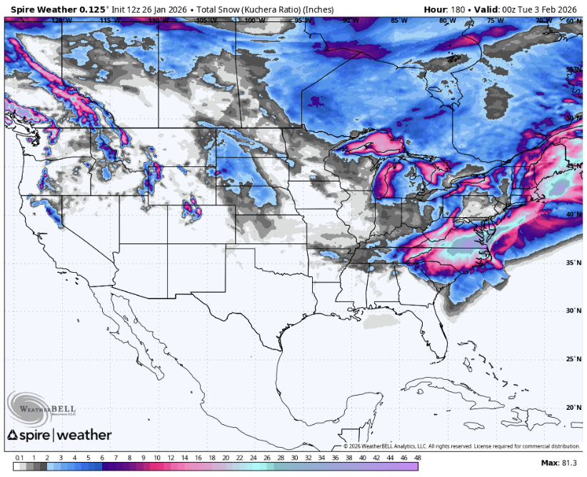
-
The “I bring the mojo” Jan 30-Feb 1 potential winter storm
BornAgain13 replied to lilj4425's topic in Southeastern States
18z Euro and Euro AI are big hits.
.png.c741e5b5c90b56a84f416d92fce93c5f.png)

.png.fdf6b3a273cadc054dcce6a5e7804a02.png)


.png.7f1209f4f42e59bdd4e4f664b88dbce4.png)


.png.1a8c8b0112a8dd8b3f31de1f332ab009.png)


