

BornAgain13
-
Posts
4,468 -
Joined
-
Last visited
Content Type
Profiles
Blogs
Forums
American Weather
Media Demo
Store
Gallery
Everything posted by BornAgain13
-

The “I bring the mojo” Jan 30-Feb 1 potential winter storm
BornAgain13 replied to lilj4425's topic in Southeastern States
Would love to see the Euro group come back.... -
The “I bring the mojo” Jan 30-Feb 1 potential winter storm
BornAgain13 replied to lilj4425's topic in Southeastern States
Model waffling continues. 0z UK was a decent hit. 12z is Out To Sea -
The “I bring the mojo” Jan 30-Feb 1 potential winter storm
BornAgain13 replied to lilj4425's topic in Southeastern States
UK not gonna do it this run. -
The “I bring the mojo” Jan 30-Feb 1 potential winter storm
BornAgain13 replied to lilj4425's topic in Southeastern States
12z CMC.thumb.png.3a809390e785652dcd4a659a707ad7dd.png)
-
The “I bring the mojo” Jan 30-Feb 1 potential winter storm
BornAgain13 replied to lilj4425's topic in Southeastern States
The CMC was a touch off from the 0z Run but not a huge difference -
The “I bring the mojo” Jan 30-Feb 1 potential winter storm
BornAgain13 replied to lilj4425's topic in Southeastern States
12z CMC with a solid run! Not as strong as the GFS but still a big hit! -
The “I bring the mojo” Jan 30-Feb 1 potential winter storm
BornAgain13 replied to lilj4425's topic in Southeastern States
2 Feet+ here on GFS. Oh if only the Euro showed something similar..thumb.png.990513eebe8a93b3af35c913f79f9031.png)
-
The “I bring the mojo” Jan 30-Feb 1 potential winter storm
BornAgain13 replied to lilj4425's topic in Southeastern States
12z GFS with a Monster SnowStorm -
The “I bring the mojo” Jan 30-Feb 1 potential winter storm
BornAgain13 replied to lilj4425's topic in Southeastern States
AI GFS is a big hit! FWIW -
The “I bring the mojo” Jan 30-Feb 1 potential winter storm
BornAgain13 replied to lilj4425's topic in Southeastern States
Consider me not smart lol -
The “I bring the mojo” Jan 30-Feb 1 potential winter storm
BornAgain13 replied to lilj4425's topic in Southeastern States
Someone smarter than me can extrapolate the NAM. But it looked like it has potential at the end? -
The “I bring the mojo” Jan 30-Feb 1 potential winter storm
BornAgain13 replied to lilj4425's topic in Southeastern States
Im not liking the trends y'all, especially with the Euro and WeatherNext. But its still early. If 12z continues to kick this thing out, then that may be the nail in the coffin especially with how close we are to the event. If we dont get it here, im rooting for yall in Raleigh and down east. Could be a big one for yall -
The “I bring the mojo” Jan 30-Feb 1 potential winter storm
BornAgain13 replied to lilj4425's topic in Southeastern States
Would love to see some of the Mets chime in on what they are seeing with a general view of all guidance. @eyewall @Disc @high risk -
The “I bring the mojo” Jan 30-Feb 1 potential winter storm
BornAgain13 replied to lilj4425's topic in Southeastern States
Looking at the 6z GFS , if u toggle back a couple of runs, it was trending to what it showed at 6z. If only we could get it to hold. Having lost the Euro i have my doubts. -
The “I bring the mojo” Jan 30-Feb 1 potential winter storm
BornAgain13 replied to lilj4425's topic in Southeastern States
6z Euro just disappeared well east. -
The “I bring the mojo” Jan 30-Feb 1 potential winter storm
BornAgain13 replied to lilj4425's topic in Southeastern States
Did anyone mention the AI GFS? It trended much more west and NW with QPF. Taken verbatim it would be a big hit
-
The “I bring the mojo” Jan 30-Feb 1 potential winter storm
BornAgain13 replied to lilj4425's topic in Southeastern States
More model fluctuations will happen today.. dont think it gets more locked in until later tomorrow. This system is so touchy. The Euro and gfs may swap places at 12z today lol -
The “I bring the mojo” Jan 30-Feb 1 potential winter storm
BornAgain13 replied to lilj4425's topic in Southeastern States
6z EPS with a big shift east.thumb.png.be9dc7c91be115d2aea86bf7788f0e58.png)
-
The “I bring the mojo” Jan 30-Feb 1 potential winter storm
BornAgain13 replied to lilj4425's topic in Southeastern States
6z Euro is a miss to the east according to the mid Atlantic forum. Its stuck on pivotal. -
The “I bring the mojo” Jan 30-Feb 1 potential winter storm
BornAgain13 replied to lilj4425's topic in Southeastern States
If only the GFS was right but I feel that it may be late to the party so to say... and the Euro Team has already sniffed out this thing going further east. I hope im wrong. -
The “I bring the mojo” Jan 30-Feb 1 potential winter storm
BornAgain13 replied to lilj4425's topic in Southeastern States
6z Euro AI with a small tick NW but overall similar to 0z. -
The “I bring the mojo” Jan 30-Feb 1 potential winter storm
BornAgain13 replied to lilj4425's topic in Southeastern States
6z GEFS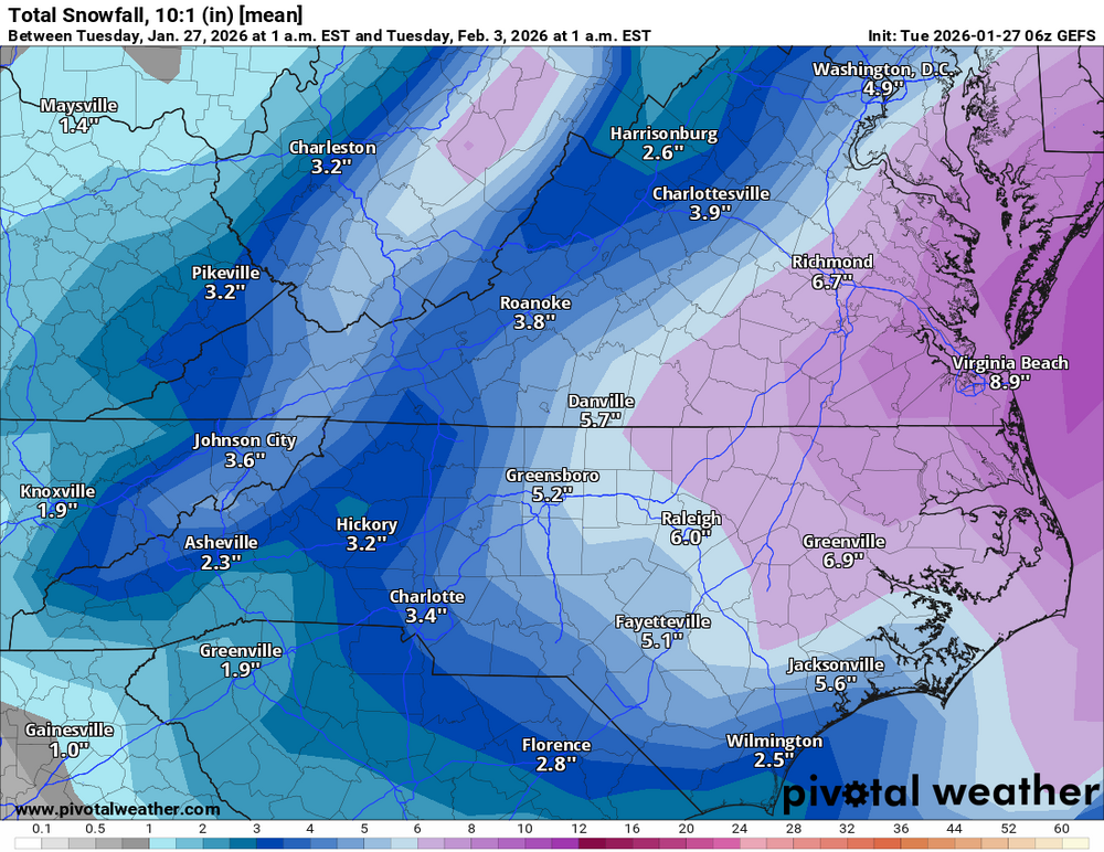
-
The “I bring the mojo” Jan 30-Feb 1 potential winter storm
BornAgain13 replied to lilj4425's topic in Southeastern States
6z GFS finally throws that bone lol. Huge run -
The “I bring the mojo” Jan 30-Feb 1 potential winter storm
BornAgain13 replied to lilj4425's topic in Southeastern States
6z icon is OTS. -
The “I bring the mojo” Jan 30-Feb 1 potential winter storm
BornAgain13 replied to lilj4425's topic in Southeastern States
Definitely not good runs on the Euro group during the night going more away.

.png.734317d85457bd1286bda3961c6f797a.png)
.png.86aaeaa918357ef00737d96c0c28b1c8.png)

.png.02b625dd8b5446f243f1fd5c5e4e7057.png)

