

BornAgain13
-
Posts
4,468 -
Joined
-
Last visited
Content Type
Profiles
Blogs
Forums
American Weather
Media Demo
Store
Gallery
Everything posted by BornAgain13
-

The “I bring the mojo” Jan 30-Feb 1 potential winter storm
BornAgain13 replied to lilj4425's topic in Southeastern States
Hopefully the 18z Euro drops the hammer on everyone. -
The “I bring the mojo” Jan 30-Feb 1 potential winter storm
BornAgain13 replied to lilj4425's topic in Southeastern States
So close yet so far -
The “I bring the mojo” Jan 30-Feb 1 potential winter storm
BornAgain13 replied to lilj4425's topic in Southeastern States
Good run for South Carolina -
The “I bring the mojo” Jan 30-Feb 1 potential winter storm
BornAgain13 replied to lilj4425's topic in Southeastern States
18z GFS not gonna get it done. Closes off to late. Edit... gets it done in some areas! -
The “I bring the mojo” Jan 30-Feb 1 potential winter storm
BornAgain13 replied to lilj4425's topic in Southeastern States
But its a step in the right direction from 12z. -
The “I bring the mojo” Jan 30-Feb 1 potential winter storm
BornAgain13 replied to lilj4425's topic in Southeastern States
18z ICON looks good! Hopefully GFS keeps coming back this way -
The “I bring the mojo” Jan 30-Feb 1 potential winter storm
BornAgain13 replied to lilj4425's topic in Southeastern States
Pic? -
The “I bring the mojo” Jan 30-Feb 1 potential winter storm
BornAgain13 replied to lilj4425's topic in Southeastern States
Model waffles will continue for the next couple of days before honing in on a scenario. -
The “I bring the mojo” Jan 30-Feb 1 potential winter storm
BornAgain13 replied to lilj4425's topic in Southeastern States
EPS/GEFS/UK Ensemble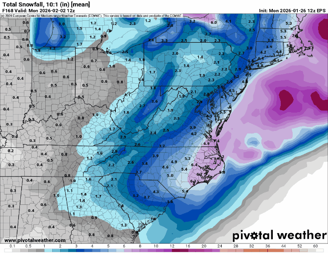
-
The “I bring the mojo” Jan 30-Feb 1 potential winter storm
BornAgain13 replied to lilj4425's topic in Southeastern States
12z EPS did follow the OP and go more east but it's still in a good spot this far out! Still a great signal!.thumb.png.e991cc6bbc941887863ab893c59fce44.png)
-
The “I bring the mojo” Jan 30-Feb 1 potential winter storm
BornAgain13 replied to lilj4425's topic in Southeastern States
Totals were still big for NC but not further north. -
The “I bring the mojo” Jan 30-Feb 1 potential winter storm
BornAgain13 replied to lilj4425's topic in Southeastern States
Just 1 run but central and eastern NC do really good!.thumb.png.c4f43c258f4af7137499a3deca534796.png)
-
The “I bring the mojo” Jan 30-Feb 1 potential winter storm
BornAgain13 replied to lilj4425's topic in Southeastern States
Yes! Its not far off -
The “I bring the mojo” Jan 30-Feb 1 potential winter storm
BornAgain13 replied to lilj4425's topic in Southeastern States
12z CMC Ensemble with a big jump west compared to 0z -
The “I bring the mojo” Jan 30-Feb 1 potential winter storm
BornAgain13 replied to lilj4425's topic in Southeastern States
12z EURO is east. Has some light snow but nothing like 6z. -
The “I bring the mojo” Jan 30-Feb 1 potential winter storm
BornAgain13 replied to lilj4425's topic in Southeastern States
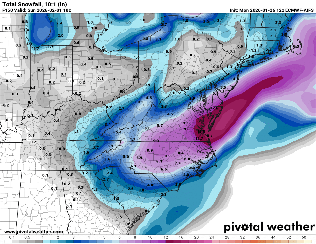
Euro AI is a tick east but still a big hit. These are just 10:1. These totals would be much higher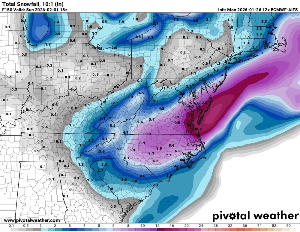
-
The “I bring the mojo” Jan 30-Feb 1 potential winter storm
BornAgain13 replied to lilj4425's topic in Southeastern States
.thumb.png.a3f09d9f41aacf364f6bd44622c7932c.png)
-
The “I bring the mojo” Jan 30-Feb 1 potential winter storm
BornAgain13 replied to lilj4425's topic in Southeastern States
12z GEFS is solid and better than the OP -
The “I bring the mojo” Jan 30-Feb 1 potential winter storm
BornAgain13 replied to lilj4425's topic in Southeastern States
UK is a moderate storm for some. But it gets in their late. -
The “I bring the mojo” Jan 30-Feb 1 potential winter storm
BornAgain13 replied to lilj4425's topic in Southeastern States
CMC agrees with Euro! Monster hit! -
The “I bring the mojo” Jan 30-Feb 1 potential winter storm
BornAgain13 replied to lilj4425's topic in Southeastern States
12z GFS is for Eastern NC but just a small adjustment and its a big dog -
The “I bring the mojo” Jan 30-Feb 1 potential winter storm
BornAgain13 replied to lilj4425's topic in Southeastern States
That is still possible! 5 days out. -
The “I bring the mojo” Jan 30-Feb 1 potential winter storm
BornAgain13 replied to lilj4425's topic in Southeastern States
Blend of Models Trend for the Potential Storm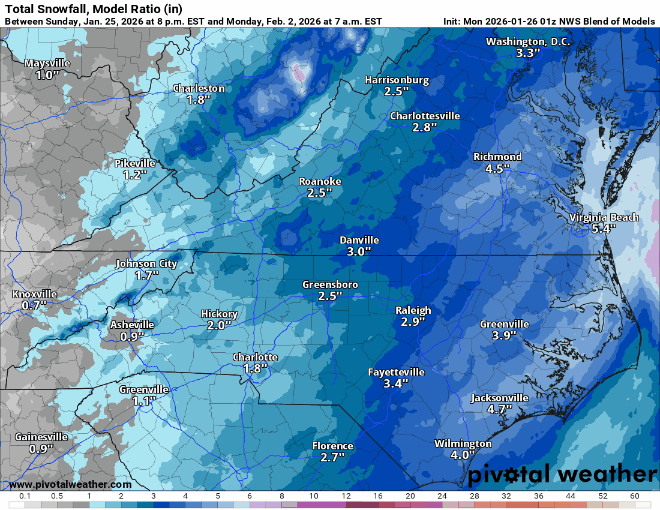
-
The “I bring the mojo” Jan 30-Feb 1 potential winter storm
BornAgain13 replied to lilj4425's topic in Southeastern States
Look at the temps while its snowing. Temps in the 10s and pouring Snow. -
The “I bring the mojo” Jan 30-Feb 1 potential winter storm
BornAgain13 replied to lilj4425's topic in Southeastern States
.thumb.png.96e310dca2b86a40ce9ee2fd90dde853.png)

.png.f078a474952cd6754a08b35ba570df91.png)
.png.755fbaa151116ee8a821c03948b1bc4b.png)

.png.d98a1549de722c0ce7d8b34f736990ec.png)
.png.355768d4b8776ab583b85b95cd8f0363.png)

