Hoosier
-
Posts
47,183 -
Joined
Content Type
Profiles
Blogs
Forums
American Weather
Media Demo
Store
Gallery
Everything posted by Hoosier
-
Even if Joaquin would've made landfall in, say, the Carolinas as many models had been suggesting at one point or another, how unusual would that have been? Northwestward moving storms into the Gulf coast/Southeast seem pretty routine.
-
great pic!
-

What's the most unstable sounding you've ever seen?
Hoosier replied to Hoosier's topic in Lakes/Ohio Valley
I can tell you all about it...we specialize in 80 degree dews in the LAF. Plainfield is a good reminder that you still need to keep an eye out on days that may not look like much tornadic wise at first glance. -
What's the most unstable sounding you've ever seen?
Hoosier replied to Hoosier's topic in Lakes/Ohio Valley
bump...here's another version of the Peoria sounding from the Plainfield tornado day. Sick, sick stuff. -
Yeah, if we're thinking about the same video, it's kinda cool how the tree waited to go down until right after the strongest winds passed. lol The cool thing about stuff like this now is that everybody gets it on camera.
-
I've wondered what it would've been like if areas closer to the surface low had been able to destabilize. I remember someone posting a model image the night before that had good CAPE all the way into northern Indiana with a string of supercells running pretty much the entire length of the state.
-
June 15-17 was a big severe weather event. The 16th/17th were high risk days for much of the subforum except the fringe areas in the north, east, and south.
-
Here is the NARR from the mornings of June 21 and June 22. Pretty amazing to see 850 mb temps below 0C in the Lakes.
-
Come on, even you would be whining about 30s in late June.
-
I was pretty young but I have some vague memories of that summer. Looking back at the dailies, LAF had a low of 35 degrees on June 22, which really sticks out like a sore thumb when you look at records for surrounding dates.
-
I don't spend a lot of time in this forum but it's been my understanding that it's mostly been used for climate change discussions on the larger scale. So, inevitably there is the issue about where to post about climate changes/trends for any given city or more localized regions. Personally I don't have a problem with those types of posts in the subforums as long as it stays on a basic level without getting too deep into the reasons for changes. Numbers are not debatable, reasons behind the numbers are.
-
beavis, I found a wind chill of -58F for ORD on 12/24/1983. Temp was -25F with wind of 25 mph
-
February 1936 might also be worth checking. It was ridiculously cold especially in the northern Plains/upper Midwest.
-
Thanks for the info. Where did you find it?
-
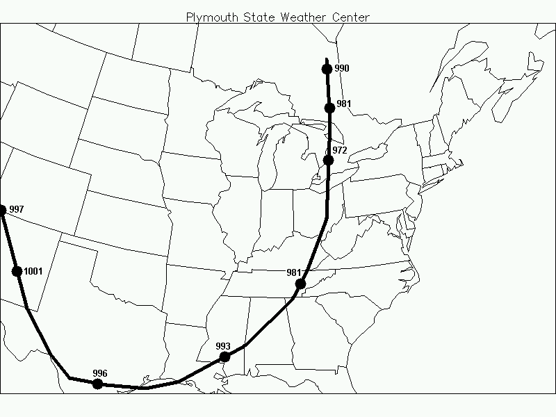
There was easily a 40-50 mb pressure gradient with that storm, so it must've been pretty windy. I was working on a blizzard project a while back but gave it up due to the workload...anyway one of the storms I was working on was 1/12/1918. Here is the approximate track and strength at various points. Numbers could be a bit off since I converted from inches to mb but should be pretty close.
-
Related to this...here is a study about the frequency of various wind chill readings in the northern US. http://www.crh.noaa.gov/crh/ssd/pdf/tsp_15.pdf Too bad they didn't do a map for wind chills of -50 or -60.
-
I don't know where to get hourly data from back then.
-
Muncie might've been lower that day...winds were stronger but there's no temperature data so I can't say for sure.
-
Wish we had wind chill info for 1/12/1918. Basically it was a weaker version of the 1978 Cleveland bomb but it brought in bitter cold air behind it. Some of the numbers must've been pretty low.
-
-53F at IND on 1/20/1985 (temp -22, sustained wind 23 mph) but I've only checked a couple of the notorious cold dates so far.
-
Devastating tornado strikes Joplin, Missouri
Hoosier replied to Hoosier's topic in Weather Forecasting and Discussion
I think that one had a very limited area of EF4 damage. I want to say only one structure but not sure. -
Devastating tornado strikes Joplin, Missouri
Hoosier replied to Hoosier's topic in Weather Forecasting and Discussion
Hard to believe it will be 1 year. I think we knew that it was serious based on the initial reports but I never imagined it would be as bad as it was. -
Devastating tornado strikes Joplin, Missouri
Hoosier replied to Hoosier's topic in Weather Forecasting and Discussion
Not that my opinion matters as much as Dr. Forbes' but I agree with that assessment. Tri-State is in a class by itself and then there are some interchangeable ones farther down the list. I think one could actually make a case that Joplin is #2 but it comes down to how heavily one weights the number of fatalities in years past. Given relatively similar damages when adjusted for inflation, are the 255 St Louis deaths of 1896 more impressive than the ~160 Joplin deaths? -
Devastating tornado strikes Joplin, Missouri
Hoosier replied to Hoosier's topic in Weather Forecasting and Discussion
Went back and looked at some stuff and came across the 00z SGF sounding. Pretty impressive -
Devastating tornado strikes Joplin, Missouri
Hoosier replied to Hoosier's topic in Weather Forecasting and Discussion
Yeah you just beat me to it