

Hoosier
-
Posts
47,183 -
Joined
Content Type
Profiles
Blogs
Forums
American Weather
Media Demo
Store
Gallery
Everything posted by Hoosier
-

Devastating tornado strikes Joplin, Missouri
Hoosier replied to Hoosier's topic in Weather Forecasting and Discussion
I'd probably do the same thing but it's bad advice for the general public, especially in a rain-wrapped case like yesterday when even experienced chasers can be caught in precarious positions. -
Devastating tornado strikes Joplin, Missouri
Hoosier replied to Hoosier's topic in Weather Forecasting and Discussion
I guess it depends if a lot of the fatalities occurred in the commercial areas. It looks like it mowed down a lot of residential real estate. I just think having it plow through at a time of day when everyone is completely oblivious is probably worse. -
Devastating tornado strikes Joplin, Missouri
Hoosier replied to Hoosier's topic in Weather Forecasting and Discussion
This year is becoming like 2005 was for hurricanes...and the next couple days look really active. -
Devastating tornado strikes Joplin, Missouri
Hoosier replied to Hoosier's topic in Weather Forecasting and Discussion
There were some bad circumstances as you mentioned, but yeah, I'm surprised. Joplin is practically in the middle of tornado alley so you'd expect preparedness/awareness to be better than most areas. I always thought the next 100 fatality tornado would occur in a sizeable population center outside of tornado alley or at a big outdoor sporting event. I think we will have to take a look at the entire system to see what improvements can be made, but it may be that there are not a lot of practical solutions. -
Devastating tornado strikes Joplin, Missouri
Hoosier replied to Hoosier's topic in Weather Forecasting and Discussion
http://www.ajc.com/news/nation-world/nws-joplin-storm-an-955263.html -
Devastating tornado strikes Joplin, Missouri
Hoosier replied to Hoosier's topic in Weather Forecasting and Discussion
Looks like a confirmed high-end EF4 so far but survey still ongoing. -
Devastating tornado strikes Joplin, Missouri
Hoosier replied to Hoosier's topic in Weather Forecasting and Discussion
That makes it the deadliest since the Woodward, OK tornado of April 9, 1947, and currently the 9th deadliest on record in the US. -
Devastating tornado strikes Joplin, Missouri
Hoosier replied to Hoosier's topic in Weather Forecasting and Discussion
Yeah, good point. -
Devastating tornado strikes Joplin, Missouri
Hoosier replied to Hoosier's topic in Weather Forecasting and Discussion
The hurricane parallel to this event is something like Charley in 2004. Everyone knows about the potential (or they should), warnings are in effect, but the rapid ramp up into a beast catches people off guard. I really can't think of a worse set of circumstances for Joplin unless it would've hit at night. -
Devastating tornado strikes Joplin, Missouri
Hoosier replied to Hoosier's topic in Weather Forecasting and Discussion
Forward motion wasn't extremely fast but it wasn't a slow mover either. I think it was somewhere around 40 mph give or take. -
Devastating tornado strikes Joplin, Missouri
Hoosier replied to Hoosier's topic in Weather Forecasting and Discussion
We've been incredibly unlucky this year with major tornadoes hitting large population centers. As far as fatalities, you really have to go back to 1953 (Waco, Flint/Worcester) to find something like this less than a month apart. Unfortunately, this type of thing may become less rare in the future with all the population growth and expansion. -
Devastating tornado strikes Joplin, Missouri
Hoosier replied to Hoosier's topic in Weather Forecasting and Discussion
-
Posting this here as it may become a story of national interest... Obviously we have to wait for the survey but it looks like it may have been a violent tornado. The tornado appears to have tracked across the southern portion of the city and quite wide. It only happened a few hours ago and there are already reports of 24 deaths, but that number will probably rise. Joplin has a population of about 50,000. This is the latest example of a major tornado striking a densely populated area, an all too frequent occurrence this year. We have a member from Joplin by the name of JoMo. He was posting in the severe weather thread until the tornado approached. It is unclear whether he was hit but we have not heard from him since the tornado struck. Please keep him in your thoughts.
-
What's the most unstable sounding you've ever seen?
Hoosier replied to Hoosier's topic in Lakes/Ohio Valley
I still can't get over that Bangladesh sounding. What would a warning look like? ...RADAR INDICATED A DANGEROUS SEVERE THUNDERSTORM CAPABLE OF PRODUCING VIOLENT TORNADOES AND BASKETBALL SIZE HAIL... -
What's the most unstable sounding you've ever seen?
Hoosier replied to Hoosier's topic in Lakes/Ohio Valley
Today was about as unstable of a mid-May day here as I can recall. -
What's the most unstable sounding you've ever seen?
Hoosier replied to Hoosier's topic in Lakes/Ohio Valley
We'd need to know the helicity to get a close approximation. Just looking at the CAPE and crudely estimating the helicity, I'd say the EHI would be over 15 and possibly approaching 20. -
What's the most unstable sounding you've ever seen?
Hoosier replied to Hoosier's topic in Lakes/Ohio Valley
With that shear... wicked -
What's the most unstable sounding you've ever seen?
Hoosier replied to Hoosier's topic in Lakes/Ohio Valley
ILX ran a special 18z sounding on 7/13/04: Low level flow isn't that impressive but there's nice veering with height. Also check out the max hail size...I have no idea how that is calculated -
What's the most unstable sounding you've ever seen?
Hoosier replied to Hoosier's topic in Lakes/Ohio Valley
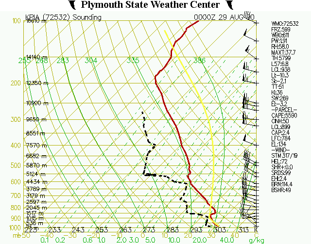
Peoria sounding is the closest thing we have. Given the surface obs at the time of the tornado, I'm guessing the thermodynamic environment in northern IL was very similar. -
What's the most unstable sounding you've ever seen?
Hoosier replied to Hoosier's topic in Lakes/Ohio Valley
We need a RAOB site in Indiana or Kentucky -
What's the most unstable sounding you've ever seen?
Hoosier replied to Hoosier's topic in Lakes/Ohio Valley
Yeah it's harder to get the good shear this far south in summer. Usually you have to rely on some freak meso/microscale interactions to produce strong/violent tornadoes. -
What's the most unstable sounding you've ever seen?
Hoosier replied to Hoosier's topic in Lakes/Ohio Valley
Jesus...I knew 8/4 was really unstable but I didn't realize it was that unstable. I wonder what instability is like in that area of the Middle East that often gets dewpoints well into the 80's. -
Obviously there are different ways to measure instability but I'm focusing on CAPE. I remember one from IA or NE last year or the year before which had MLCAPE well over 5000 (maybe over 6000). 7/13/04 was another crazy unstable day with SBCAPE over 7000 in IL. Another good one is the Peoria sounding from 8/28/90 with MLCAPE over 5500 (SBCAPE of 7000-8000 IIRC)
-
Historic Tornado Outbreak April 27, 2011
Hoosier replied to CUmet's topic in Weather Forecasting and Discussion
That is really impressive. -
Historic Tornado Outbreak April 27, 2011
Hoosier replied to CUmet's topic in Weather Forecasting and Discussion
I won't be surprised if the final number surpasses the total from 1974.