
leo2000
-
Posts
650 -
Joined
-
Last visited
Content Type
Profiles
Blogs
Forums
American Weather
Media Demo
Store
Gallery
Everything posted by leo2000
-
Confirms what I have been thinking (so far). We shall see though.
-
The data seems to show though that this SSW event is a combined reflective-absorptive sudden stratospheric warming event. The reflection phase allows for the Alaskan Ridge and a positive AO and positive NAO in the near term. Absorbing Phase: Subsequently, the stratosphere switches to an absorbing state, where it absorbs the upward wave energy, leading to a breakdown or weakening of the polar vortex. This absorption phase causes downward propagation of anomalous winds and is typically associated with a negative phase of the AO/NAM, leading to an increased likelihood of cold air outbreaks in mid-latitudes, particularly across North America and Eurasia. Tropospheric Impacts The distinct phases of a combined event lead to a sequence of different weather impacts on the Earth's surface: Near-term (Reflective Phase): Stronger westerlies and an active storm track across northern Europe may be observed, with temporary ridging in the North Pacific. Medium-term (Absorptive Phase): Increased pattern uncertainty emerges as the vortex breaks down, typically leading to the negative AO pattern and potential severe winter cold in mid-latitude regions. From Met Jens Bonewitz Stratospheric Update: hashtag#Potential Combined Reflective-Absorptive hashtag#SSW Developing! Following yesterday's discussion (link: https://lnkd.in/egEFCFuq), models continue to indicate persistent hashtag#wave-1 forcing on the stratospheric polar vortex (SPV) extending into December—this time driven primarily by an intensifying hashtag#Aleutian Low. We may be witnessing a combined or consecutive reflective-absorptive hashtag#SSW event. As discussed in the recent hashtag#Hannachi et al. (2025) paper, these complex events occur when upward propagating planetary waves first reflect off the disturbed vortex (creating negative heat fluxes that temporarily strengthen the SPV and accelerate the polar jet), before subsequently being absorbed, leading to vortex breakdown and downward wave activity flux propagation to the troposphere. Expected hashtag#Tropospheric Response: Near-term (into early hashtag#December): hashtag#Pacific: Temporary Alaskan Ridge (AkR) development; N Atlantic: Positive AO/NAO as reflected waves accelerate the jet stream—stronger westerlies and active storm track across northern EuropMedium-term (mid-late December): Increasing pattern uncertainty as absorption phase dominates. Downward coupling from the disturbed SPV likely triggers AO/NAO trend reversal. Enhanced (negative) blocking potential across Atlantic-European sector. Key hashtag#Uncertainty: The timing and magnitude of stratosphere-troposphere coupling in consecutive wave forcing events remains highly non-linear. While the ~60-day lag framework provides guidance, the volatile nature of this setup challenges deterministic forecasts beyond 2-3 weeks. hashtag#Graphics (attached): Time-height evolution of max.wave-1 height amplitude showing sustained and intense forcing in the upper and into the middle stratosphere (1-10 hPa) from late November through early December; source, incl.latest hashtag#forecast: https://lnkd.in/esD7gEtP. The persistent high-amplitude wave activity (>1500-1900 gpdm in the upper stratosphere) represents the continuous pressure on the polar vortex—key driver for the potential reflective-absorptive hashtag#SSW sequence. Additional Context: 500 hPa hashtag#GFS forecast (30 Nov) showing the main tropospheric driver: intense hashtag#Aleutian Low. Note the deep low pressure system over the North Pacific providing upward wave forcing into the stratosphere. Additional diagnostics: https://lnkd.in/eM2nHteb https://lnkd.in/eXr7cGtG
-
It's here folks!
-
Euro weeklies look really good
-
When I type on Google asking about the major SSW will it be either reflective or absorptive the answer has changed before it said reflective now it's saying a combined reflective- absorptive event. Starting out as a reflective phase transitioning into an absorptive phase. Which is why the AO is turning positive with the reflective phase then it will transition mid to late December into the absorptive phase which will flip the AO and NAO both negative. This information is compiled by numerous sources. So December is far from toast. The GEFS shows the MJO going into phase 8. Since, someone is confused I am going to copy the information here. AI Overview The major Sudden Stratospheric Warming (SSW) event forecast for late November and early December 2025 is anticipated to be a potential combined reflective-absorptive event. According to current meteorological models and expert analysis, the event exhibits characteristics of both types, which will influence the timing and location of the resulting weather impacts. Event Type and Expected Progression Initial Reflective Phase (Near-term/Early December): The initial phase is expected to be dominated by wave reflection, where upward-propagating planetary waves temporarily bounce off the disturbed polar vortex. Effect: This phase will likely temporarily strengthen the stratospheric polar vortex and accelerate the polar jet stream, leading to a positive Arctic Oscillation (AO) and North Atlantic Oscillation (NAO) and stronger westerlies across northern Europe in the short term. Surface Response: This might result in a temporary Alaskan Ridge (AkR) development in the Pacific. Subsequent Absorptive Phase (Medium-term/Mid-late December): The reflective phase is expected to be followed by a dominant absorptive phase, where the waves are subsequently absorbed, leading to a breakdown or displacement of the polar vortex and the downward propagation of wave activity to the troposphere. Effect: This absorption will increase pattern uncertainty and is the phase typically associated with a weakened polar vortex, which allows frigid Arctic air to plunge south into lower latitudes. Surface Response: This second phase is expected to lead to cold air outbreaks and potential snow events across parts of the United States, Canada, and Europe as the polar vortex becomes disrupted. The specific classification as a combined event highlights the complexity of this particular SSW and suggests a dynamic, multi-phase impact on Northern Hemisphere winter weather patterns. https://www.linkedin.com/posts/jens-bonewitz-b43002142_potential-ssw-wave-activity-7398315457403064320-w1Uq#:~:text=Jens Bonewitz's Post-,Jens Bonewitz,uncertainty as absorption phase dominates.
-

November 2025 general discussions and probable topic derailings ...
leo2000 replied to Typhoon Tip's topic in New England
Yes, Don was mentioning it with evidence to back it up a forecast that shows it latter now. -
November 2025 general discussions and probable topic derailings ...
leo2000 replied to Typhoon Tip's topic in New England
Very nice theirs some chatter over on the other side of this forum about a robust positive AO we shall see. -
Most of the time it does sometimes it doesn't but most of the time it does.The AO is fluctuating now but doesn't mean it's going to take stay positive.
-
Yes there is, the AO looks to go positive but it's only temporary then return negative or neutral state within the next two weeks. The weeklies also keep an negative EPO which did well last winter. I also don't think we are losing a negative EPO as all forecasts have it diving deeply negative some even have it below -4 sigma.
-
Seems like some utter nonsense talk about a possible AO and positive NAO . A major SSW favors, negative AO and negative NAO phases.
-
The weeklies have gotten even colder and stormier.
-
Brutally cold and snowy winter on the way. I know Don was mentioning about the cold pool is much smaller than in 1968 but this is not arctic air coming it is Siberian cold and with the pdo rising that would increase snowstorm chances.
-
November 2025 general discussions and probable topic derailings ...
leo2000 replied to Typhoon Tip's topic in New England
Different answer on Google search ai answer says as few days to a couple of weeks for a major SSW to be felt in the mid latitudes such as North America and eastern Canada. With the effects potentially lasting up to two months. Regardless, there comes a risk with this as we could end up getting a suppressed storm track depends on where the SPV sets up right over Hudson Bay is ideal. -
The models are simply overdoing the warmth expect more cold dominating over the warmth.
-
November 2025 general discussions and probable topic derailings ...
leo2000 replied to Typhoon Tip's topic in New England
Showing a fantasy storm for Nova Scotia already in the long range a good sign. Gfs 18z at 360 hours lol. -
The best you can ask for really its going to happen for sure now.
-
Some of the operational runs bring it more out east. We will have to see.
-
I got this from Grace over in wx sphere she seems pretty knowledgeable about the weather. Of course the Pacific is the driver it can make make or break Winter. I would not worry though we are going to have a strong negative EPO and a positive Pna or negative Pna.
-
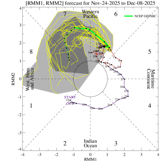
Yes, nothing awful about MJO phase 6 in December so of course phase 7 would be even better. Phase 6, La Nina DEC
-
February may not be a lost month this winter either.
-
The Climate Prediction Center is also showing what the Euro Weeklies is showing with the cold air and above precip and a SE ridge down to the south.
-
I heard from here the cold air will bleed east. Question is, is this a Siberian event? or North Atlantic event type SSW. As the Siberian event lasts longer the models seem to indicate that it's an Siberian event. I am rather confuse though as the EPS model went from 81 percent predicting a major SSW down to 56 percent last night. This is from Ben Noll on X. @BenNollWeather A sudden stratospheric warming event is forecast to peak around Nov. 25. This will probably disrupt the polar vortex, with Arctic air initially plunging into the west-central United States during late November, accentuating the stormy weather pattern headed for this region. https://x.com/i/status/1989324943415234596 Just two months after a rare stratospheric warming event disrupted the polar vortex above Antarctica, one is poised to do the same above the Arctic before the end of November. Watch the Southern Hemisphere's vortex go from perfectly round to ragged. https://x.com/i/status/1989347337932607567
-
Yes we don't want to get too cold suppression depression happens then. We also don't want the shreddar pattern either like we had last year. An interesting video from Met DT about December.
-
November 2025 general discussions and probable topic derailings ...
leo2000 replied to Typhoon Tip's topic in New England
Getting a better Pacific as we head into December can't have both a good Atlantic and Pacific have to lose one rather lose the Atlantic anytime over the Pacific anyday. Still a decent atlantic too though it seems. -
Wow indeed 82 percent now!!! This is from Allan Huffman on Twitter he says: Today's 12z op ECMWF and EPS mean both show the 10mb U wind turning negative, meaning a change to an easterly wind direction over the polar regions and an #SSWE with 41 of 50 EPS members (82%) showing this reversal with 11/25 the day with the most negative members. Sudden Stratospheric Warming Events, can weaken the tropospheric polar vortex, allowing for increased high latitude blocking (-AO) and the enhanced risk for arctic air discharge into the mid-latitudes (North America, Europe, East Asia). A late November SSWE is relatively rare, and COULD help favor a cold start to meteorological winter(December). The last November SSWE was in 1968.


