Jump to content

leo2000

Weenie
  • Posts

    638
  • Joined

  • Last visited

Everything posted by leo2000

  1. Those Euro weeklies are horrendously warm!
  2. That was a strong El Nino that faded into a weak La Nina.
  3. Yes, that looks to be happening and even if it gets mild somewhat in early January but that may not happen as models have been forecasting warm in the long range and it never materializes. I think we could have indeed some storm threats before Christmas and on Christmas itself.
  4. I got the feeling we are going to have a early January thaw for the first two weeks of January then back to the colder pattern we had since late November into all of February.
  5. Risky business to bet on the "coast to coast" ridge holding firm at the margins, as I've been warning @weathertrader (I'm hyping cold right now) Polar vortex anchored over Hudson Bay just needs a subtle nudge and it dumps out e.g. Day 12 (AI-GFS)
  6. Interesting situation happening here the big warm up is being muted by the latest Euro Ensembles as the -WPO is fighting back. On the other hand the latest GEFS holds onto the big warm up and so does the GEPS.
  7. I know many are down on this big warm up the up side however is this may actually offer a chance for a big coastal storm as the cold pattern relaxes.
  8. They are too you can see the EPO ridge in Alaska high heights where before there was low heights. This could a trend GEFS 12z shows this.
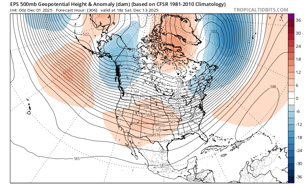
  9. A lot of people are forgetting all it takes is a transitional +PNA to get a big storm to pop on the east coast. Speaking about that models seem to be showing that on the 13th of December. I watch that period very closely for a miller b snowstorm.
  10. Yeah overall cold but I don't like seeing those low heights over Alaska ak vortex.
  11. So we should expect the models to be getting colder?. For some reason the Ak vortex is still there plus the EPS this morning did not look that cold.
  12. I don't buy the +EPO with MJO going in phase 8 along with the weak polar vortex. I do think a +PNA is coming.
  13. Confirms what I have been thinking (so far). We shall see though.
  14. The data seems to show though that this SSW event is a combined reflective-absorptive sudden stratospheric warming event. The reflection phase allows for the Alaskan Ridge and a positive AO and positive NAO in the near term. Absorbing Phase: Subsequently, the stratosphere switches to an absorbing state, where it absorbs the upward wave energy, leading to a breakdown or weakening of the polar vortex. This absorption phase causes downward propagation of anomalous winds and is typically associated with a negative phase of the AO/NAM, leading to an increased likelihood of cold air outbreaks in mid-latitudes, particularly across North America and Eurasia. Tropospheric Impacts The distinct phases of a combined event lead to a sequence of different weather impacts on the Earth's surface: Near-term (Reflective Phase): Stronger westerlies and an active storm track across northern Europe may be observed, with temporary ridging in the North Pacific. Medium-term (Absorptive Phase): Increased pattern uncertainty emerges as the vortex breaks down, typically leading to the negative AO pattern and potential severe winter cold in mid-latitude regions. From Met Jens Bonewitz Stratospheric Update: hashtag#Potential Combined Reflective-Absorptive hashtag#SSW Developing! Following yesterday's discussion (link: https://lnkd.in/egEFCFuq), models continue to indicate persistent hashtag#wave-1 forcing on the stratospheric polar vortex (SPV) extending into December—this time driven primarily by an intensifying hashtag#Aleutian Low. We may be witnessing a combined or consecutive reflective-absorptive hashtag#SSW event. As discussed in the recent hashtag#Hannachi et al. (2025) paper, these complex events occur when upward propagating planetary waves first reflect off the disturbed vortex (creating negative heat fluxes that temporarily strengthen the SPV and accelerate the polar jet), before subsequently being absorbed, leading to vortex breakdown and downward wave activity flux propagation to the troposphere. Expected hashtag#Tropospheric Response: Near-term (into early hashtag#December): hashtag#Pacific: Temporary Alaskan Ridge (AkR) development; N Atlantic: Positive AO/NAO as reflected waves accelerate the jet stream—stronger westerlies and active storm track across northern EuropMedium-term (mid-late December): Increasing pattern uncertainty as absorption phase dominates. Downward coupling from the disturbed SPV likely triggers AO/NAO trend reversal. Enhanced (negative) blocking potential across Atlantic-European sector. Key hashtag#Uncertainty: The timing and magnitude of stratosphere-troposphere coupling in consecutive wave forcing events remains highly non-linear. While the ~60-day lag framework provides guidance, the volatile nature of this setup challenges deterministic forecasts beyond 2-3 weeks. hashtag#Graphics (attached): Time-height evolution of max.wave-1 height amplitude showing sustained and intense forcing in the upper and into the middle stratosphere (1-10 hPa) from late November through early December; source, incl.latest hashtag#forecast: https://lnkd.in/esD7gEtP. The persistent high-amplitude wave activity (>1500-1900 gpdm in the upper stratosphere) represents the continuous pressure on the polar vortex—key driver for the potential reflective-absorptive hashtag#SSW sequence. Additional Context: 500 hPa hashtag#GFS forecast (30 Nov) showing the main tropospheric driver: intense hashtag#Aleutian Low. Note the deep low pressure system over the North Pacific providing upward wave forcing into the stratosphere. Additional diagnostics: https://lnkd.in/eM2nHteb https://lnkd.in/eXr7cGtG
  15. When I type on Google asking about the major SSW will it be either reflective or absorptive the answer has changed before it said reflective now it's saying a combined reflective- absorptive event. Starting out as a reflective phase transitioning into an absorptive phase. Which is why the AO is turning positive with the reflective phase then it will transition mid to late December into the absorptive phase which will flip the AO and NAO both negative. This information is compiled by numerous sources. So December is far from toast. The GEFS shows the MJO going into phase 8. Since, someone is confused I am going to copy the information here. AI Overview The major Sudden Stratospheric Warming (SSW) event forecast for late November and early December 2025 is anticipated to be a potential combined reflective-absorptive event. According to current meteorological models and expert analysis, the event exhibits characteristics of both types, which will influence the timing and location of the resulting weather impacts. Event Type and Expected Progression Initial Reflective Phase (Near-term/Early December): The initial phase is expected to be dominated by wave reflection, where upward-propagating planetary waves temporarily bounce off the disturbed polar vortex. Effect: This phase will likely temporarily strengthen the stratospheric polar vortex and accelerate the polar jet stream, leading to a positive Arctic Oscillation (AO) and North Atlantic Oscillation (NAO) and stronger westerlies across northern Europe in the short term. Surface Response: This might result in a temporary Alaskan Ridge (AkR) development in the Pacific. Subsequent Absorptive Phase (Medium-term/Mid-late December): The reflective phase is expected to be followed by a dominant absorptive phase, where the waves are subsequently absorbed, leading to a breakdown or displacement of the polar vortex and the downward propagation of wave activity to the troposphere. Effect: This absorption will increase pattern uncertainty and is the phase typically associated with a weakened polar vortex, which allows frigid Arctic air to plunge south into lower latitudes. Surface Response: This second phase is expected to lead to cold air outbreaks and potential snow events across parts of the United States, Canada, and Europe as the polar vortex becomes disrupted. The specific classification as a combined event highlights the complexity of this particular SSW and suggests a dynamic, multi-phase impact on Northern Hemisphere winter weather patterns. https://www.linkedin.com/posts/jens-bonewitz-b43002142_potential-ssw-wave-activity-7398315457403064320-w1Uq#:~:text=Jens Bonewitz's Post-,Jens Bonewitz,uncertainty as absorption phase dominates.
  16. Yes, Don was mentioning it with evidence to back it up a forecast that shows it latter now.
  17. Very nice theirs some chatter over on the other side of this forum about a robust positive AO we shall see.
  18. Most of the time it does sometimes it doesn't but most of the time it does.The AO is fluctuating now but doesn't mean it's going to take stay positive.
  19. Yes there is, the AO looks to go positive but it's only temporary then return negative or neutral state within the next two weeks. The weeklies also keep an negative EPO which did well last winter. I also don't think we are losing a negative EPO as all forecasts have it diving deeply negative some even have it below -4 sigma.
  20. Seems like some utter nonsense talk about a possible AO and positive NAO . A major SSW favors, negative AO and negative NAO phases.
  21. The weeklies have gotten even colder and stormier.
×
×
  • Create New...