

Eskimo Joe
-
Posts
19,211 -
Joined
-
Last visited
Content Type
Profiles
Blogs
Forums
American Weather
Media Demo
Store
Gallery
Posts posted by Eskimo Joe
-
-
2 minutes ago, thunderbolt said:
Is there any news stations covering this
Fox 45 has been live off and on on their Facebook page.
-
-
-
-
-
4 minutes ago, Random Chaos said:
Another gauge just south of EC at 13.89"
https://www.wunderground.com/personal-weather-station/dashboard?ID=KMDELLIC60
Gauge about 2 miles south of EC reporting 4"/hr rainfall rates now.
-
-
1 minute ago, GramaxRefugee said:
Currently stuck in a SWA flight at ATL. Diverted here with broken wx radar. Now no flights may be dispatched to BWI due to wx there. Keeping eye out. Anyone verify that Catonsville gauge report?
Two gauges near each other reported 10 - 12"...radar estimate 9.3". I'd say it's valid.
-
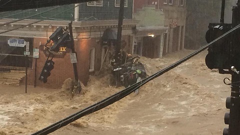
Water approaching 2nd floor of some buildings in EC now.
-
-
Howard 911 getting calls of buildings collapsing in EC now.
-
 1
1
-
-
M12.53" Catonsville w/ ~1"/hr rates still..amazing.
-
M10.03" Catonsville
-
Going to be interesting to see what happens in Montgomery County...storms firing in Damascus and may ride that outflow boundary down I-270.
-
Just now, smokeybandit said:
Looks like it peaked at 27.03 feet. 2016 was 27.1 feet.
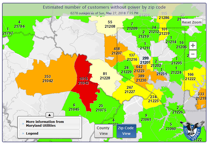
Power is out in the area...might be debris clogged in the gauge too.
-
-
Tornado Warning in WV
Quote000
WFUS51 KLWX 272205
TORLWX
WVC027-031-272230-
/O.NEW.KLWX.TO.W.0010.180527T2205Z-180527T2230Z/BULLETIN - EAS ACTIVATION REQUESTED
Tornado Warning
National Weather Service Baltimore MD/Washington DC
605 PM EDT SUN MAY 27 2018The National Weather Service in Sterling Virginia has issued a
* Tornado Warning for...
Northeastern Hardy County in eastern West Virginia...
South central Hampshire County in eastern West Virginia...* Until 630 PM EDT.
* At 604 PM EDT, a severe thunderstorm capable of producing a tornado
was located 9 miles northeast of Moorefield, moving southeast at 15
mph.HAZARD...Tornado.
SOURCE...Radar indicated rotation.
IMPACT...For those in the direct path of a tornado touchdown,
flying debris will be dangerous to those caught without
shelter. Damage to roofs, siding, and windows may occur.
Mobile homes may be damaged or destroyed. Tree damage is
likely.* This dangerous storm will be near...
Wardensville around 630 PM EDT.Other locations impacted by this tornadic thunderstorm include
Inkerman, Rio, Perry, Bean Settlement, Baker and Mccauley.PRECAUTIONARY/PREPAREDNESS ACTIONS...
TAKE COVER NOW! Move to a basement or an interior room on the lowest
floor of a sturdy building. Avoid windows. If you are outdoors, in a
mobile home, or in a vehicle, move to the closest substantial shelter
and protect yourself from flying debris.&&
LAT...LON 3910 7892 3918 7884 3912 7852 3893 7868
TIME...MOT...LOC 2204Z 303DEG 12KT 3914 7882TORNADO...RADAR INDICATED
HAIL...<.75IN$$
BJL
-
LWX radar estimates are in line with the 2016 flood (6"+ in ~2hrs).
-
Several rain gauges are reporting 2 - 3" rainfall rates still in Howard and Baltimore counties.
-
This is going to be worse than the 2016 floods. Between this and the Baltimore County/City flooding, it's definitely more pronounced.
-
Wow at this language:
Quote
000
WGUS71 KLWX 272129
FFSLWXFlash Flood Statement
National Weather Service Baltimore MD/Washington DC
529 PM EDT SUN MAY 27 2018MDC005-027-272330-
/O.CON.KLWX.FF.W.0017.000000T0000Z-180527T2330Z/
/00000.0.ER.000000T0000Z.000000T0000Z.000000T0000Z.OO/
Howard MD-Baltimore MD-
529 PM EDT SUN MAY 27 2018...THIS IS A FLASH FLOOD EMERGENCY FOR ELLICOTT CITY AND
CATONSVILLE AND NEIGHBORING AREAS......THE FLASH FLOOD WARNING REMAINS IN EFFECT UNTIL 730 PM EDT FOR
EAST CENTRAL HOWARD AND SOUTHWESTERN BALTIMORE COUNTIES...At 526 PM EDT, there have been numerous widespread reports of
significant flash flooding, water rescues, and damage throughout the
area. More substantial heavy rain is moving into the area, so even
in areas where floodwaters started to subside earlier, it is very
likely that flooding will persist and most likely worsen. This is an
EXTREMELY DANGEROUS AND POTENTIALLY CATASTROPHIC situation and you
must move to HIGHER GROUND IMMEDIATELY AND STAY AWAY FROM ANYWHERE
WHERE WATER IS MOVING!!!!This is a FLASH FLOOD EMERGENCY for Ellicott City and Catonsville.
This is a PARTICULARLY DANGEROUS SITUATION. SEEK HIGHER GROUND NOW!Some locations that will experience flooding include...
Ellicott City, Catonsville, Woodlawn, Arbutus, Ilchester and Oella.This includes flood prone locations
River Road along the Patapsco River...
Security Boulevard near Dead Run Near I-70...
Park Drive at Church Road...
and Chatham Road at Route 40.PRECAUTIONARY/PREPAREDNESS ACTIONS...
Move to higher ground now. This is an extremely dangerous and
life-threatening situation. Do not attempt to travel unless you are
fleeing an area subject to flooding or under an evacuation order.Turn around, don't drown when encountering flooded roads. Most flood
deaths occur in vehicles.Move to higher ground now. Act quickly to protect your life.
&&
LAT...LON 3928 7671 3927 7670 3924 7670 3924 7678
3925 7687 3927 7688 3931 7671$$
JE
-
Just now, losetoa6 said:
I just saw a Catonsville station at 8.35"

Link?
-
9 hours ago, nw baltimore wx said:
Does anyone know a way to kill or control common English ivy? If you look at the picture above, I've got a lot of it creeping in under my Leylands on two sides of my yard from my neighbor's yards. They aren't deliberately growing it, so I could kill it, but I don't know of anything that I can use that won't kill everything else. Right now my plan is to run my edger along the neighbor's edge of the property just deep enough to cut the ivy and then pull it all out, but that's going to be a lot of work, and then I'll somehow have to control it to keep it from running back in. Not to mention that I'll probably end up with poison ivy for the rest of the summer.
Anyone have suggestions?
All sweat and elbow grease. It's like mint. Just pull until you can't pull anymore.
-
 1
1
-
-
2018 Mid-Atlantic General Severe Discussion
in Mid Atlantic
Posted
With the Patapsco River now swollen, it's going to take a long time for the south end of town to dry out...well past nightfall before flooding ends there.