

Eskimo Joe
-
Posts
19,071 -
Joined
-
Last visited
Content Type
Profiles
Blogs
Forums
American Weather
Media Demo
Store
Gallery
Posts posted by Eskimo Joe
-
-
Eye becoming visible on satellite. Cat 4 by tomorrow AM?
-
Maria's eye is looking much better defined on radar since this time yesterday:
-
Hurricane warning issued for the U.S. Virgin Islands.
-
When, if ever, do you think we will have an ice free summer in the arctic?
-
I had to retake ODE in the spring b/c of this storm......
That was an epic few days with you, me and Anthony looking at the SREFs and ensembles.
-
This is quite impressive. A cool summer that has owned my garden from start to finish.
-
I don't know where else to put this:
000
SXUS71 KLWX 261943
RERIAD
RECORD EVENT REPORT
NATIONAL WEATHER SERVICE BALTIMORE MD/WASHINGTON DC
340 PM EDT WED MAR 26 2014
...RECORD MONTHLY MARCH SNOWFALL SET AT WASHINGTON DULLES DC...
SO FAR THIS MARCH...MONTHLY SNOWFALL IS NOW UP TO 19.8 INCHES...
WHICH INCLUDES SNOWFALL THROUGH MARCH 25. THIS BREAKS THE PREVIOUS
MARCH MONTHLY SNOWFALL OF 15.5 INCHES TALLIED IN MARCH 1993.
A FINAL RECORD EVENT REPORT WILL BE SENT AT THE END OF THE MONTH.
$
SMZ/DH -
I was in Lancaster at the time, and just completed my last undergraduate finals. Graduation was the next day, but when I saw the north trend the night before, I packed up early on the 18th and drove back to Philadelphia while the roads were still good. I was quite happy to have gotten out of there and back to Philly because my neighborhood consists of tiny streets that never get plowed in a 6" snowstorm, let alone an 18" event.
-
I know this thread isn't 100% related to what my question is, but it was the first one to show up in my search so..... Here I go! I'm a junior in high school who is interested in Meteorology, but right now I'm thinking I may be inclined to major in Aerospace engineering as it is a subject I really enjoy as well and the job prospects seem somewhat better. It is obviously a bit early, but I am compiling a list of prospective colleges to look at/apply to... So far, these are some of the schools on my list..
-University of Texas
-University of Washington
-Georgia Tech
-Rice University
-University of California San Diego
As might be able to tell, I am not really into staying around New England, but that could change. So after all that background, my question becomes, do any of these schools have Meteorology programs, and if so, what are their reputations? If I start college and don't like Aerospace, it'd be good to have Met as a fallback. Also, if there any other schools you guys think of that might suit my desires, I'm open to suggestions.
You should check out Millersville University's met program too. There are tons of undergraduate research / internship opportunities that MU can assist you with.
Link to Earth Sciences dept: http://www.millersville.edu/esci/
-
During severe season, what is meant by CAPE?
CAPE is an acronym for Convective Available Potential Energy, and is used as a metric when identifying the potential for convection (thunderstorm activity). It must be stressed that CAPE is the end all for determining severe weather risk, but is certainly important. Remember that air must have buoyancy (ability to rise) and then condense to form clouds, rain, hail, etc and CAPE provides a measure of this buoyancy. The higher this buoyancy, the quicker air will rise and begin the formation of thunderstorms. The CAPE value is measured in Joules per kilogram (J/Kg) and, generally, you need a minimum of 1,000j/kg of CAPE to see severe weather (Blanchard, 1998). CAPE can reach values of up to 5,000J/Kg, but that is reserved for rare events, such as large scale severe weather outbreaks. Here in the Mid Atlantic a good day is when CAPE gets to ~2,000J/Kg. There are two other types of CAPE talked about in forecast discussions and severe weather outlooks: MLCAPE (Mixed Layer CAPE) and SBCAPE (Surface-Based CAPE). Unfortunately I am not adept at explaining these two terms, but if you were to Google: SPC + MLCAPE or SPC + SBCAPE there are several good snippets of information. Hope this helps!
Reference:
Blanchard, D. O. (1998). Assessing the Vertical distribution of Convective Available Potential Energy. American Meteorological Society, 13, 870 - 877.:
-
Honestly, I'm not positive either. It's just what I've gleaned through years of reading and thinking and I'm probably off in my explanation. Great thread to be corrected in though because I don't know where else I can post this kind of stuff and discuss it. We're only as good as what we know and if what we know is wrong it doesn't help much.
There is a significance of where a noreaster becomes vertically stacked and how it impacts our area but I don't know the finer details.
This is a pretty good loop of the 12/19 storm. Maybe a met can chime in and explain it in more detail?
Fantastic discussion here. Also, that .gif is superb.
-
This is what happened as I recall, the times may not be correct and it may not have completely happened how I remember it but this is what I remember.
We are very used to having tornado warnings in Joplin. The first instinct of everyone when they hear the sirens is to jump up and go outside to look for it. It's even a joke between me and Wx24/7 that once a storm enters the Springfield, MO CWA, they'll issue a tornado warning for it no matter what.
I had been watching the HRRR all day Sunday and noticed that it was developing the very last storm over Joplin but nothing farther south. The helicity was scary crazy as well. I thought this was maybe just the HRRR being flaky until I saw the storm develop over SE KS and that it was moving SE.
As I remember it, the parent supercell storm that was moving SE developed a couple of cells on it's SE flank. These storms went from nothing but a small blip to a storm in no time at all. SPC mesoanalysis was showing 5000 SBCAPE. The last images other than the base velocity radar image I saw was the LFC and LCL heights, which were both 1000 over the area.
As the storm(s) were approaching, I heard constant rolling thunder and lightning. I was watching the initial parent thunderstorm, it had an unorganized couplet that was rather large and I knew it would slide by to the north of me. South of that another couplet was developing on the second 'blip' that had popped up. This one was farther south than the first one but was still really unorganized. I do believe both were Tornado warned. Then suddenly a third storm rapidly developed south of those storms. A tornado warning was issued that included my area and this was the one that produced the EF-5 tornado.
I watched it go from no couplet to a big bad couplet right over me in a few minutes time. ( I just watched the video that someone posted that showed how quickly the tornado went from a tiny rope to a giant wedge and I'm amazed.) I looked out the window to the west and the sky was pretty much black, much like how it looks when the sun is out at your location and there is a storm some distance away, only this time it was cloudy where I was. There was a lowering which was probably part of the wall cloud. It gave off an orangish hazy looking color against the black sky.
The sirens had gone off for one of the other tornado warnings, but they were going off a second time as well. It was then I heard what I thought was rolling thunder... only this time, it got louder.
I listened to the 'rolling thunder' get louder for about 5-10 seconds before I figured out that it was not thunder. I looked up towards where I heard the sound but the blinds were closed so I decided to get in the only safe place which was a closet before the windows blew out. As I turned on the closet light, the power went out. I was not really expecting an EF-5.
The sound was exactly like what people compare it to, a freight train. It was a loud roar, and it had times where it almost sounded like it was growling. The winds at my location were from the north or northwest because I heard the air screaming in the garage door, it screamed, stopped for a few seconds and then screamed again and then the roar got quieter so I ventured out.
I looked into the rest of the house, no glass was broken, still had a roof. I decided to look outside and despite having a tree that fell over, most of the other trees had no damage. It was now foggy outside though. I suspected I had just been through a weak tornado. I went outside and the first thing I smelled when I made it outside was the smell of freshly cut trees or wood. I thought that was a little strange, but some neighbors trees had broken limbs so I thought it was from that. The roof had sustained some shingle damage but nothing really bad.
I came back inside and I turned on a battery powered radio because I was wondering what the rest of the city was getting or what had happened. It was then I heard that St. Johns Hospital was 'leveled' (a report that was not true, although it had sustained heavy heavy damage) I was like.. whoa that's not good. It was around that time I heard firetruck/ambulance sirens. These sirens ran constantly from right after the tornado hit at around 5:40 PM until midnight. They also ran a lot the next day as well.
I walked down the street, heading to a local church (there's almost one on every corner here) and as I was walking that way I noticed a lot of trees down on just the next street over and the damage got progressively worse. People's privacy fences had been blown over, but this was nothing compared to what I saw at the end of the block. As I was walking I noticed the smell of natural gas, it was getting stronger the closer I got but I just had to see. People had gathered at the church and it was being used as some sort of local triage for minor wounds. I kept walking until I reached the end of the block where everything to the south of the intersection was completely destroyed. I looked down the street and I didn't recognize anything and I realized I could see much much much farther than I could before. There was a lot of traffic that was being turned around there and I didn't want to interfere with the rescue work so I returned home.
I didn't sleep at all that Sunday night, the days events, the sounds, the thought that I wouldn't probably be here if the tornado was three blocks closer, all kept replaying in my head.
I let the rescuers do their thing on Monday and it was raining most of the day, but on early Tuesday morning I walked back down there and down the street, and I almost could not stop walking. The entire area looked like it was a landfill. On my left, a car parked in the 'garage' where a house would have been but there was nothing but a slab there, water gushing out of a broken pipe. On my right, another street where nothing remained but debris. On the ground there was a St. Johns medical braclet from someone.
The streets were marked by wooden signs spray painted with the street name. "Haz gas" was spray painted on a piece of wood next to a gas meter, a couple of guys pulled up to check and make sure it wasn't leaking still, it was, so one of them phoned the gas company to tell them it was still leaking. The area was being patrolled by police officers from the area and from other counties farther away, but they didn't have much to say or didn't care I was there since I was on foot.
I ran into a lady who had brought a camera to take pictures, she told me that the State trooper guarding the intersection had told her that she had to see it. Pictures don't really do it justice though, people who have lived here all their lives and are older get turned around and lost because there are no landmarks left since it's just a debris field. It reminds me of a post-apocalyptic scene but it's real life. I probably stood on top of a hill and looked around for about 10 minutes at everything, how far I could see and where the damage path was then I returned home.
I decided to go back on Wednesday, a little later in the day and people had returned home to gather their belongings. There were also rescue workers in the area. I saw a boy and his mother on the 2nd floor of what was left on their house. It didn't exactly look safe but nobody was stopping them. I heard an insurance adjustor talking to a woman as another woman was inside what was left of their house attempting to gather whatever she could. I saw a man sitting on the back deck of his destroyed home, holding his head. I looked down and saw that a bunch of debris had gathered down in this valley and rescue workers were there, attempting to find people in the rubble I guess. I felt uneasy and like I was intruding so I decided to return home.
The last trip down there I took this evening. They had cleared away a bunch of the trees. The road was blocked by electrical trucks working on the electric lines, I didn't want to disturb them so I just watched them work. There was other equipment working in the area as well, no heavy equipment yet though.
There have been helicopters flying over for the past few days. I don't remember what day it was but there were 2 blackhawk copters from the National Guard on patrol then two A-10's flew by. I'm not really sure what the point of all that was and most of my neighbors thought it was really stupid. It's not like they were protecting us from some kind of invasion or something.
The city has a curfew in the disaster zone from 9 PM to 6 AM. You can't be in the area after that time. They were going to make people get permits, but they ran out of permits pretty quickly so they just decided to beef up security.
This radio station did a great job of locating people and getting information out there:
Very happy to hear you are okay. Here is a link that I feel will make everyone appreciate the true impact of the storm.
In response to the bold text, that is typical for when the POTUS comes in. The military will practice the flight route.
-
From the "first person" video, why is there a distinct break in the wind? You hear a roar, you hear screaming and then there is silence which clearly makes the people in the video think that the tornado has passed prior to the real damage starting at 3:10s. Just curious if that was just a downdraft or perhaps a sat tornado.
Yeah, I saw it discussed earlier-- it was probably a microburst or some localized disturbance preceding the arrival of the main core circulation. (And, in itself, that "appetizer" wind was quite destructive-- it was strong enough to smash all the store windows and pelt the building with debris.) It seems that this system was complex, and that the actual primary vortex was perhaps embedded in an envelope of damaging winds.
Could just be multiple vortices revolving around each other a la planets in a solar system.
-
Wowsers!
That is just stunning.
-
Based on what all of you have said, wouldn't this map put JoMo right in the damage zone? I don't know much about this stuff, but that's how the map looks to me. Still keeping JoMo and everyone else affected by this in my thoughts and prayers.
I honestly have no idea who JoMo is, but from what I've read he lives in Joplin. Not sure what part of town so I will not speculate.
-
I agree with you on decimal degrees and you are welcome for the compliment

I need to brush up on KML, play around with it some more. My mind is going crazy thinking of all the cool things you could with the data.
Yes, KML (Keyhole Markup Language for those not familiar with the term) has really enabled the geographically enthused population to map features in software such as Google Earth. In term of meteorology and the Joplin, MO tornado a person could take a picture of damage, reference it with standard lat/lon coordinates and then upload the file in KML format for anyone to view on the web. This really emphasizes the connection between geography and the earth sciences.
-
Well, from someone who works with GIS daily, it's a fantastic map!
Have you worked with KML files (google earth) before? It would cool if you could take those storm reports points with the attribute data and export them to KML files so they can be opened into GE for people to view (Norman did that with the tracks, but didn't have anything you could click on).
Thank you for the compliment, it's now a part of my sig
Yes, I make KML files for NASA on a weekly basis. I think I'm going to hold back on the KML until I get enough data in. I considered a rough overlay of the SPC reports, but since they are in decimal degrees it's not as spatially accurate as I'd like. Disclaimer: I'm not bashing SPC at all, they do an excellent job!
-
Cool map, Joe! It's very informative, so thanks for posting it. (By the way, I don't know why anyone would be annoyed by it. This is a weather forum-- we analyze these events here.)
Re: the path, are those really the start and finish points, or just where the surveying started and ended? It's just crazy that such a large, intense tornado spun up and spun down so fast like that.
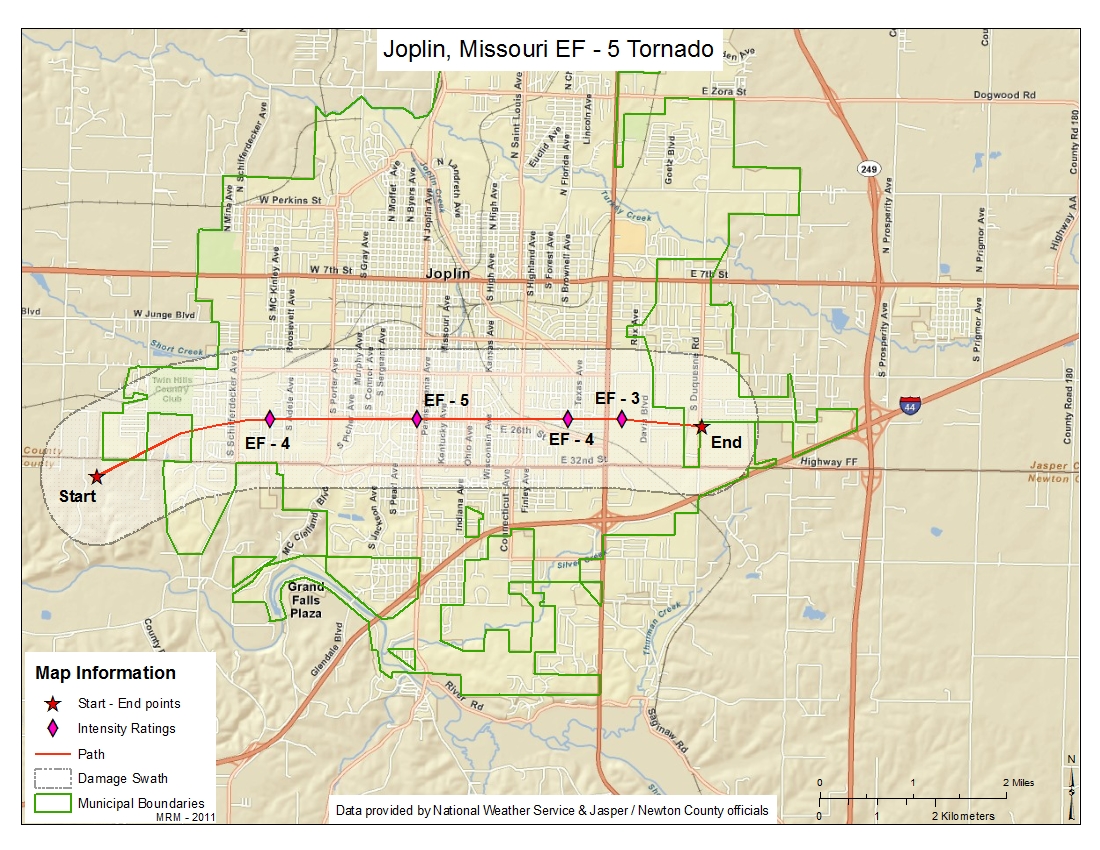
Start and End Paths were taken through this storm assessment: http://www.srh.noaa....ersion=3&max=51
The start and end points were acquired via handheld Global Positioning Satellites (GPS) on a hand held device by the assessment team. I am unsure at this time if the storm was skipping before or after those two points.
Nicely done!
Did you buffer out the width of damage along the line?
Yes, and I'm looking to find point locations of damage reports (ie: where a tree was de-barked or a car was flipped over) and add it into the map as a reference. Unfortunately, that information has yet to be released.
Great map. As Josh said, amazing that it was so violent and intense and had suck a (relatively) short track.
Yup, I intend to do one for Piedmont, Oklahoma once the information is released.
-
I took the liberty of making a map in the Geographic Information system (GIS) software ArcMap of the tornado as it went through Joplin. My intent is not to rub in the damage, but rather to provide a geographical reference for those not familiar with the area. Data was provided by the National Weather Service as well as the Jasper and Netwon County offices of emergency management and department of public works. Please refer to the latest media releases by the aforementioned agencies for additional information.
Hurricane Maria
in Tropical Headquarters
Posted