raindancewx
-
Posts
3,980 -
Joined
-
Last visited
Content Type
Profiles
Blogs
Forums
American Weather
Media Demo
Store
Gallery
Everything posted by raindancewx
-
It won't be of much use for this winter, but I've been working on a "Modoki" calculator for winters - will be useful if we go into an El Nino. Works fairly well using Nino 1.2, Nino 3.4, Nino 4 SSTs (raw) in October, with a recognition that each Box, Box A, B, C, must be calculated separately for the Modoki number to work correctly. The weak La Ninas and weak El Ninos seem to have their cold directly controlled by the structure of the Modoki signature, and with Box C warming quickly over time relative to the other boxes, certain types of events are becoming more likely.
-
Congrats Texans on winning the World Series - we gave you Giles & Bregman from ABQ - so pleased to see them get their rings.
-
One of the things I've always struggled with is trying to figure out the moisture signal in the SW in the cold season, since it is so dependent on the PDO. PDO+ seems to largely cancel out La Nina effects here except in November, April & May. But it looks like the PDO can be predicted by matching the Nino 1.2 reading in October before Nov-Apr, and also the PDO value for March-August before the Nov-Apr. There are never a whole lot of blends that allow an acceptable close blend on those two factors, but when blended correctly, you predict Nov-Apr surprisingly well, at least for the 10 years I have tested so far. Long and the short of it is that Nino 1.2 was frigid in October, which should keep the PDO somewhat negative, but it was still positive in Mar-Aug, which favors for somewhat positive. So I don't think this La Nina forces the PDO super negative just yet. Going by the Nino 1.2 weeklies, Nino 1.2 was -1.4C in October, v. +0.3C last October. (the blurred out years for 2009 are 1967, 1991, 1991, 1991) Oh and I left out 2011, which is a blend of 1952, 1971, and 1999.
-
Puerto Rico isn't directly hit by hurricanes super often - but the years it has been smacked around by big time hurricanes produce a pretty good match to October for a one variable match. Hot lakes, cold ID.
-
I don't think this is a terrible winter for cold in TX or the SW. Might be for moisture...but it should be much colder than last year. The cold in October is displaced much deeper into the West than last October, which is what my analogs had for the winter. So its not going to be cold...we're just closer to the cold sourcing, so the cold shots will be more frequent and stronger.
-
I think is kind of a nuts winter personally, even though on aggregate it will probably come out relatively close to average in a lot of places. Part of me thinks TX could see some kind of fluke storm in late winter, like a blend of a Blue Norther with subtropical jet moisture. October here is directly correlated to December in La Nina, so if we end up 3-4F colder, that alone favors more cold in the SW in Dec. 2016: 75.9F (+4.6F) -->49.7F 2017: ~72.5F (+1.2F) --> ?? I put this in the MO thread, but some of the analog years I like had good snows pretty deep into the South.
-
I don't have much faith in the CFS this early, but it continues to insist on a dry NW for the winter...AND a La Nina.
-
Even in populated areas of New Mexico it can occasionally snow in June & September. Snow is favored precip time above 7,000 feet or so from October to May. Nice pics. Was hoping for some snow in the city this October, but not looking likely. It only happens once a decade though. Suspect my forecast will do OK, with some issues, something always comes up. Last year it was pretty good for January nationally, less so Dec/Feb. As far as I know New Mexico doesn't have any glaciers, the permanent snow/ice line here would be like 15,000 feet above sea level, but obviously the big time mountains get close - I think July is really the issue - even at 13,000 feet its rarely cold enough to snow here in July. "Beautiful Incredible Place" is how I'd describe most of New Mexico really. If you're back by June you will be able to see the white stuff on the higher peaks. Mountains will keep getting snow into mid to late May most years. Even in the city we had an inch of snow in some areas on April 29th this year. The volcanoes (5800 feet) outside the city were the lushest I had ever seen them a few days after it melted, covered in beautiful green grasses, flowers, mud, and wildlife.
-
I have the West pretty warm in Nov, but should be fairly cold TX to ND and east.
-
The biggest thing the ice has going for it in the winter is that the AMO anomaly tends to end up at about 60% of its Summer values in Winter - which would be a much colder Atlantic than last winter. Last Summer was like +0.45 and went to +0.279 for Nov-Apr. This year, more like +0.325 in July-Sept, been assuming +0.15 or so for Nov-Apr, which is much less rare in terms of warmth.
-
We've had some really nice days here lately - down to the 30s the other night, with highs in the 60s, and then low 70s today. Some of you seem interested in skiing, and others talk about "snow fixes" so I included some snow data for the high country in winter outlook if any of you are interested. I'm expecting a pretty decent season up by Chama & Red River against their long-term averages. https://tinyurl.com/yam55n95
-
I'm somewhat optimistic for a cooler winter than last year for the SW & SE - in my area two big early predictors both favor less warmth - the number of 87F days (we had 96!) and the AMO in July to Sept. AMO in July to Sept was 0.325 or so. Last year, 0.460. That's worth around half a degree of cooling. The increase in 87F days, fro 83 to 96, is worth about a degree of cooling. Expecting the winter here to be around 49.6F, +/-2.2F. Will put up my winter outlook tomorrow.
-
Pretty sure it will be warm in Louisiana for the winter, but a lot cooler than last winter. None of that +6F to +8F garbage like last year. Maybe +1 to +3F? I have to re-do my simulations with the heavy rain we've gotten in TX/NM lately. The soil moisture does seem to impact the placement of the highs some. I think effectively there is something of a wake in zone where the sub tropical high will be because of Harvey, Irma, Jose, Katia, and Maria beating the day lights out of it and upwelling some colder ocean temperatures. My area is colder (not actually, you know cold) in La Nina winters that follow relatively long duration periods of heat. We've had (at least) 96 days 87F or higher, that tends to lead to near normal temperatures here. My area is colder (not actually cold) in La Nina winters when the Atlantic is cooler. My area also has exceptionally variable winters near the solar minimum - record heat / record cold are all near the minimum. Barring a complete bust over the next two days for highs, these years were the objective analogs that popped up for winter based on my Summer conditions - its heavily weighted to temps and preicp with low weight to ENSO. This is one method I use to look at winter - I'll give it some weight, but it isn't my forecast. The big big wild card for the winter especially late is if Mount Agung or one of these other suddenly active Ring of Fire volcanoes is going to erupt in a big way soon enough to screw up the Earth's heat intake.
-
I've had at least 0.64" rain today, one of the biggest precipitation days of the year here. Basically 48-50F from 6 pm to 9 pm with steady rain. Feels great actually. I had a wet September in my Summer outlook (from mid-May). Looks pretty good now if the NAM is right about the city getting another 0.6"-1.2" rain by Sept 30. I think I had 1.25", and we're at 0.74" right now. The link has the newest NAM outlook through 9/30/17. https://pbs.twimg.com/media/DKx3ktNU8AE9-V2.jpg:large Will be issuing my winter outlook (snow and DJF temps) sometime between Oct 7 - 15. I'll link it on here if anyone is curious.
-
1938-39 was cold in TX (La Nina), same for 1983-84, and 1984-85, 2000-01 1974-75 wasn't bad 1988-89 wasn't bad 2010-11 wasn't bad Some of the near La Ninas (cold-Neutrals) seem pretty cold in TX actually (1932, 1937, 1944, 1947, 1948, 1962, 1967, 1985, 1996, 2012, 2013)
-
WPC on board too
-
What kind of recovery would see in the ice if Agung erupts at a similar magnitude to 1963? It was a VEI 5 eruption at around 8 degrees away from the equator. I know my coldest winter in 120+ years was 1963-64. Lots of evacuations in Bali right now.
-
Am I crazy for thinking we might be entering a Dustbowl redux? Last winter (2016-17) was very similar to 1931-32 by temperature anomalies nationally. This (2017) Hurricane season is the only one since 1850, other than 1932 - to have a category four hurricane hit Florida, Texas and Puerto Rico in the same season. The PDO, Nino 3.4 (raw) temperatures, AMO (raw) temperatures, and solar activity are all almost identical to 1932 right now. To me, the Dustbowl started after how dry / warm the 1932-33 winter was for much of the Midwest. PDO: Aug 1932: -0.1. Aug 2017: +0.1 AMO: Aug 1932: 23.51C, Aug 2017: 23.66C Sunspots July-June: 1932-33: 14.5 July-June 2017-18: 18.0? Other: Both years two years after Super (Modoki) El Ninos: 1930/2015 Look at how close Nino 3.4 is for August 2017 & August 1932 too - https://pbs.twimg.com/media/DKS8WhyVAAAb3KN.jpg:large
-
Seems like in addition to the snow on the highest peaks, Eastern New Mexico will be dealing with severe weather and a big rain event later in the week. I'm expecting around 0.3" here by next week.
-
As mentioned earlier in this topic, its interesting seeing the ice extent coming back a bit with the AMO dropping a lot from last year. Came in at 0.314 in Sept 2017, down from 0.461(!) last September. We've caught 2008, and are running ahead of 2007, 2012, 2015, 2016 for sea ice extent on 9.11. We may catch 2010 or another year for lowest extent if there aren't more big losses soon. https://pbs.twimg.com/media/DJkbUBAU8AAmg72.jpg:large
-
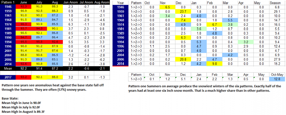
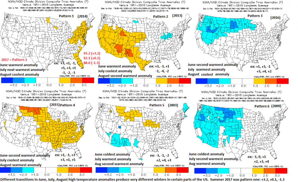
The transition in mean highs in Jun->Jul->Aug is a pretty decent indicator of snow in ABQ. We had pattern one this Summer. Against 1931-2016 mean highs, June was +3.2, July was +0.1, and August was -1.3F. Historically, going from warmer to cooler anomalies from June to July to August tends to come before a snowy winter in Albuquerque. It isn't particularly biased by El Nino either, only 35% of the years that fit the pattern are El Nino. Most are actually Neutrals (58%), which is what I expect this year to be. Pattern one Summers also tend to have slightly warmer than normal winter highs in the Northeast, even with 2014-15 in there as a striking counter-example.
-
NSIDC has sea ice extent on 8/29/17 higher than 2007, 2011, 2012, 2015, 2016. Outside chance the lowest extent date ends up above 2008 too?
-
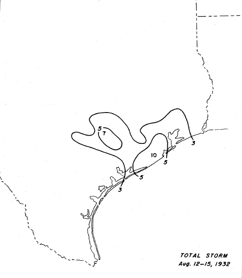
This is what I found for the 1932 Freeport Hurricane rain totals, which happened on a similar path, and with somewhat slow movement. It was a cat four though, don't think Harvey will be. Probably less wind, more rain as a result.
-
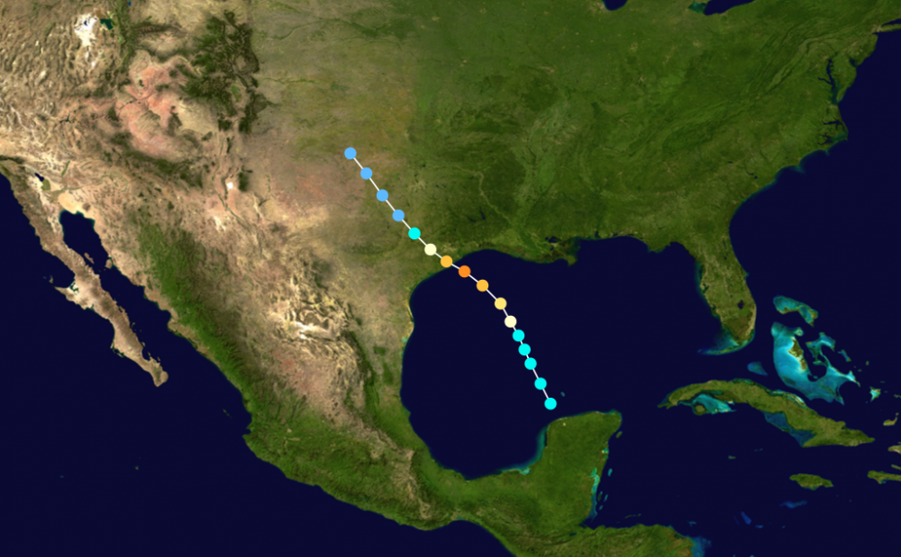
As I noted - this year is kind of like 1932 in a background sense (PDO, AMO, Solar, ENSO, ENSO sequence, Modoki status, etc). Here was hurricane two in 1932: https://en.wikipedia.org/wiki/1932_Freeport_hurricane
-
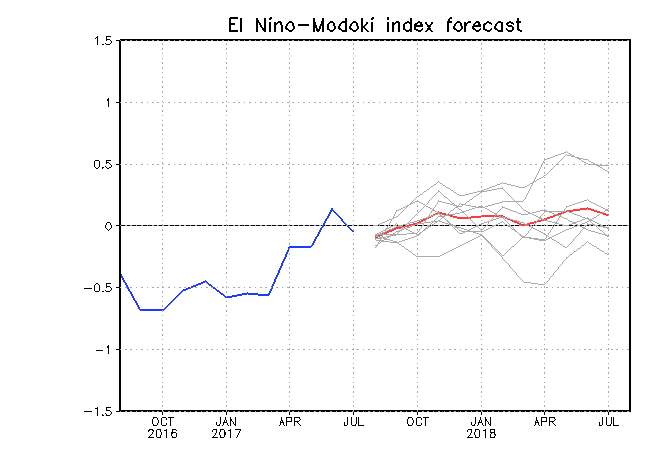
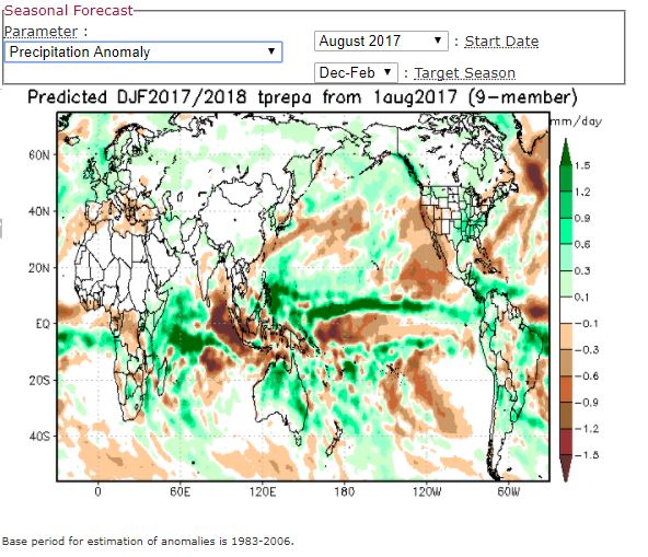
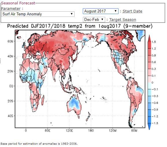
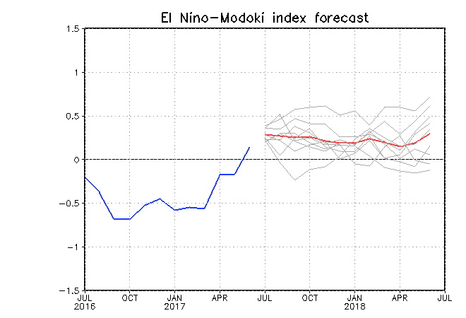
Had a lovely cloudy/cool day yesterday here, 76F for the high 60F at night. 78F or 79F today? https://t.co/on5O30hu92 Fall Outlook Anyway - Jamstec August update is in. Still likes a Neutral winter (but it uses a weird base period 1983-2006), and it has the West pretty cold now. Modoki values in winter are correlated somewhat with low solar, so I think its on the right track in dropping the Modoki value to 0, maybe to below 0 next month. >0 means Central Tropical Pacific is warmer than East/West Tropical Pacific. <0 means the opposite. So high Modoki values (>0 ) are a La Nina Traditional or El Nino Modoki signature (2009), while low values (<0) are a La Nina Modoki or El Nino Traditional signature. It does get weird, because just about La Ninas are -Modoki values, so -0.3 might be a better indicator. The +/-0 works well for El Ninos though. Last winter (DJF) was a La Nina Modoki, with -0.4C officially in DJF (after several -0.8C and -0.7C periods), with a -0.5 Modoki reading. I'm rooting for a -0.0 to -0.2 Modoki reading and a cold Neutral (-0.2 to -0.4C) ONI at this point. JAMSTEC had -0.2C in Aug 2016 for DJF 2016-17, but ended up at -0.4C. It shows +0.1C for DJF 17-18. So hopefully we stay in the negative Neutral zone. I like -0.3C or so for winter, maybe -0.5C in the Fall for one period.