

WestMichigan
-
Posts
1,135 -
Joined
-
Last visited
Content Type
Profiles
Blogs
Forums
American Weather
Media Demo
Store
Gallery
Posts posted by WestMichigan
-
-
-
1 mile visibility at GRR just before noon. It is crazy outside right now.
-
4 hours ago, weatherbo said:
Breezy, smokey, and 52 here at noon. A two day rain total of 1.68" brings the monthly total to 3.25". Woods are lush and green.
Sounds like mosquito heaven.
-
Ended up with a little over 1.5" here today. Thankfully the lake shadow didn't seem to come into play.
-
You cut off the date, when is that? ^
-
7 hours ago, fluoronium said:
My grass is cooked but tougher plants have been showing up in its place.
With all those leaves it doesn't look like much grass would grow there anyway.
-
17 minutes ago, frostfern said:
I see a lot of miss south stank for MBY even if the pattern improves marginally. El Nino is such a b****. Never in my life has a summer been as boring as this one. Not even any heat. Just cool dry and boring. The new San Diego.
No heat? How many 90 degree days has GRR had? I count 5 so far. That doesn't sound like no heat. You could make a case for lower humidity than normal.
-
22 minutes ago, Nelson said:
That's the one thing that has struck me more than anything so far this summer - the low dewpoints. I can't remember a stretch where they have been, on average, as low as they've been.
Other than lack of rain, I am not sure anyone is complaining about the low dewpoints. Except for our resident palm tree lover.
-
 1
1
-
-
Where was a discussion like this in the winter instead of the usual decline in QPF that seemed to occur with nearly every storm. We definitely need the rain so this is a good thing.
Latest GEFS/ECMWF ensembles support potential for three quarters of
an inch to an inch of rainfall from Sunday through Tuesday. A
gradual trend upward a bit in ensemble qpf has been noted the past
48 hours which seems reasonable given the evolution of the upper
level pattern.
-
And so it begins....

-
A tale of two different regimes here.
-
12 hours ago, frostfern said:
I heard soft rumble thunder and didn’t believe it because almost every direction out the window looked clear. There’s a tiny cell moving in from the SE. Might be the last rain I see for the next week though.
Damn thing is going to miss just west though. Ugh.

Same thing here. I did manage to sneak in 0.26" around 11:00 last night. Kinda surprised me given it was well after dark and the radar was clear in my area when it started.
-
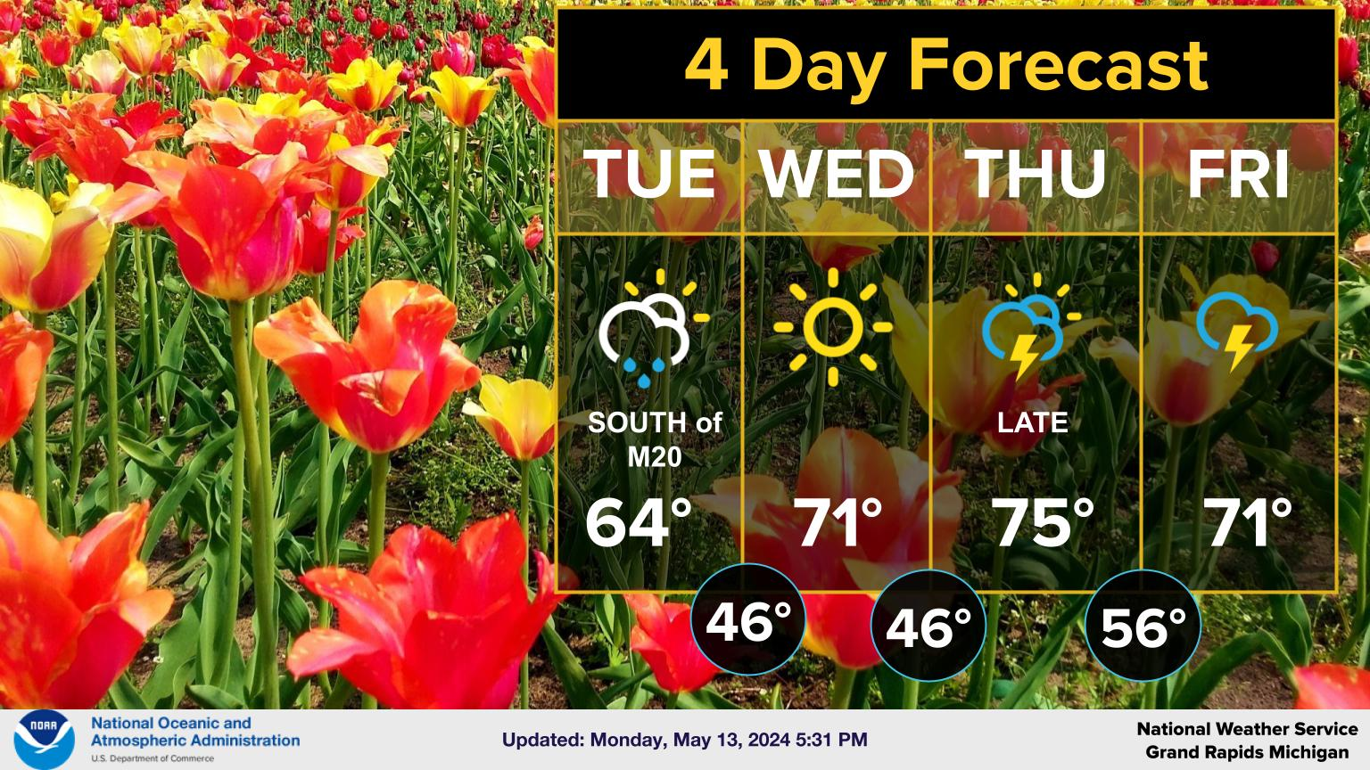
Continuing the theme of dry

It is likely that we`ll finish May without another drop of rain.
Assuming this holds, our climatological station at Grand Rapids
will finish the driest month of May since the Dust Bowl of the
1930s. May 1936 registered 0.72" of total rainfall, which is the
driest May on record, while this May is only a tad wetter at
0.84", which would rank 2nd driest at Grand Rapids. Other sites
such as Lansing and Muskegon, assuming no more rain, would end up
with the 5th driest May on record.
-
 3
3
-
-
On 5/18/2023 at 3:17 PM, Chicago Storm said:
frost is overrated for garden/foliage damage.
Tell that to the fruit tree growers.
-
34 minutes ago, frostfern said:
There actually have been some significant straight line wind events on this side of the state the last few years. There have been long periods with little garden variety or general thunder. Things get brown every summer by July. I remember garden variety storms and nocturnal heavy rain events being more common in the 90s and 00s.
When I first moved to Michigan in 2010 I distinctly remember in Holland waking up multiple times to tstorms very late at night to right before sunrise. It almost was regular enough to make me think this is how it goes in Michigan. Then reality set in over the next 12 years and I realized this was an anomaly, not the norm.
-
1
-
-
I haven't found any alternative yet. Hopefully someone has.
-
1
-
-
2 hours ago, nwohweather said:
It's the oddest thing about Michigan. You have legitimately nice neighborhoods in SE Michigan connected by gravel roads. Ohio in very rural places can have extremely narrow roads, but they're always paved
There are a lot of dirt roads in Ohio. Where I grew up in SE Ohio there are more dirt than paved.
-
17 hours ago, BuffaloWeather said:
Where do you get these maps from? Buffalo had a top 5 snowfall year and according to your map we didn't. I had 185" here with annual around 120" and it shows me 50% of normal last winter.

Just like GRR having the 3rd snowiest winter ever and being shown below normal to near normal. The resolution of the map isn't very good for local areas.
-
1
-
-
11 hours ago, weatherbo said:
Here's some final totals and the snowfall history map.
And lastly, a sign that Spring is just around the corner.
MQT:
Four days of heavy rain and snow brought record-breaking precipitation amounts across portions of Upper Michigan between April 29th and May 2nd. Of particular note was the 24-hour snowfall observation of 27" in Herman, MI on May 1st; the greatest 1- day May snowfall east of the Mississippi River in the official U.S. climate record! #906wx

Those totals for qpf are amazing. Shoveling/plowing that stuff must have been a nightmare. 52" is more in one storm than a majority of the forum received all winter.
-
 1
1
-
-
38 minutes ago, A-L-E-K said:
looks p mild to warm to me, especially western sub, lol at the northeast which looks like total piss
You passed up an opportunity to say best climo
-
 2
2
-
-
Had enough flakes this morning to turn the deck slightly slushy. Mostly rain now. Keeping the May snow streak alive for another year.
-
2
-
-
15 hours ago, IWXwx said:
The trough just keeps on troughin'


Waiting for our Dayton area friend Spartman to come on and complain how it will never get warm in his back yard this summer.
-
1
-
-
GRR temperature departures through 4/11 were +12.7. Now they stand at +3.3. Realistically the departure wasn't going to stay that high for the month but it has been quite the switch since the 11th.
-
4 hours ago, dta1984 said:
I am! Hopeful that the weather works out, but we have a backup plan just in case.
Congratulations!
-
1
-

June 2023 General Discussion
in Lakes/Ohio Valley
Posted
accuweather