

WestMichigan
-
Posts
1,242 -
Joined
-
Last visited
Content Type
Profiles
Blogs
Forums
American Weather
Media Demo
Store
Gallery
Posts posted by WestMichigan
-
-
Can you guys send a little rain this way? Things are getting pretty brown out here.
-
Grass is crunchy brown up here.
-
 1
1
-
-
6 hours ago, nwohweather said:
Gonna call this the year of the east wind
I'll second that
-
 1
1
-
-
17 hours ago, Harry Perry said:
I don’t know about all of that, but I do know that I’m enjoying one above normal day on the lake today before the weather turns to shit for the rest of the foreseeable future.
What lake are you on?
-
1 hour ago, Harry Perry said:
How. The entire state has had SO much rain, especially mid Michigan. The ground is literally saturated.
Next weeks “heat-wave” getting shorter and shorter per some guidance. Would end the week into the weekend with mid 50’s, rain and another upper level low lol. Even some Saharan dust (more mud rain).
The entire state has had SO much rain? Holland, Grand Rapids, and Muskegon are all below normal this month continuing the long term dryness.
-
Not liking the looks of this heading into summer.
-
1 hour ago, A-L-E-K said:
more dust storm related than fires but we really should get serious about how we're using (ie wasting) some of the most fertile soil on the planet growing industrial monocrops in about the most ecologically harmful manner possible
I don't disagree, but wow, that came out of left field.
-
1 hour ago, nvck said:
36mph max gust so far at the campus weather station, which is pretty impressive as the anemometer is only 10ft off the ground
Peak gust of 58mph here.
-
Solid C here. Colder temps allowed the below normal snowfall to stick around. If it wasn't for the lake this would have definitely been an F.
-
 2
2
-
-
2 hours ago, TheClimateChanger said:
So much for that UHI. DTW had a low of 29F on the 5th, versus 39F at FNT and 37F at MBS. Crazy.
Was it cloudy at the other sites?
-
Some very light snow flakes falling this morning. Not accumulating but a couple of months ago this would have been mood flakes. Now it is just a nuisance given the time of year and prior warmth.
-
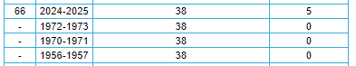
2 hours ago, IWXwx said:
2024-'25 The winter of the mid-south.
And Sault Ste Marie
-
1
-
-
Everything including the kitchen sink in this forecast.
-
1
-
-
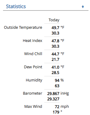
The highlighted report was form my weather station.
My yard
My neighbor's barn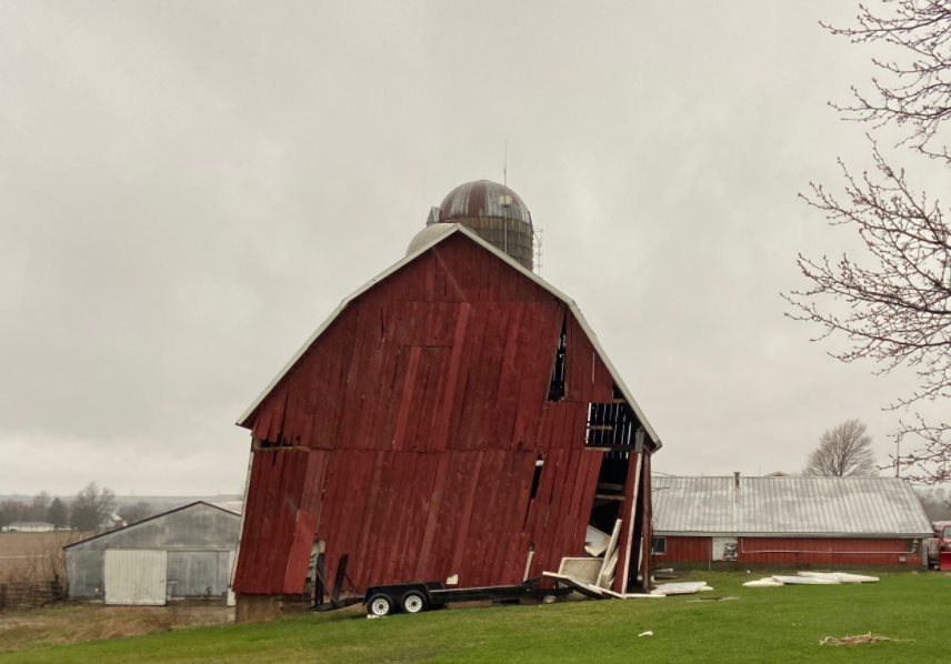
-
9
-
-
2 hours ago, Imneversatisfied said:
It's looking like a high impact freezing rain event for northern Michigan this weekend. Both GFS and CMC have freezing rain falling for over 24 hrs! Does anyone have freezing rain accumulation maps? I can't seem to find any.

-
13 minutes ago, Powerball said:
With the PV stretching out before it dissipates, there should still be a couple opportunities in the 2nd half of March for transient cold blasts and even light snowfall amounts in this subforum.
But yeah, the prospects of a significant snowfall and lost-lasting cold look increasingly unlikely at this point between the Teleconnections and MJO forecast.
One thing to watch though, as we transition into Summer, will be the worsening drought in the SW USA. It is giving shades of 2011 (although obviously the ENSO state isn't quite the same).
It isn't just the SW. Draw a diagonal line from there to Minnesota then go 500 miles either side of that. Many parts of this sub forum are pretty dry also.
-
 1
1
-
1
-
-
10 hours ago, buckeye said:
For a March snowstorm its lasting effect was solid. It got brutal cold for a couple weeks on its heels and the deep cover stuck around unusually long for the time of year.
As far as blizzard criteria, probably about an hour at the end the wind really kicked up and we had white out conditions…. But it didn’t last long.I lived just SW of the Avery Rd and Hayden Run Rd intersection and that was a snowstorm I won't forget.
-
We can't even pull off a good rainstorm this year. Yesterday the forecast was for about 1.4" at GRR. At this point breaking 0.5" might be a challenge. This lack of precipitation better change soon or it is going to be a long, hot, dry summer.
-
2
-
-
The UP is having a huge snow year and Weatherbo has been completely silent. Anyone have any idea what happened to him?
-
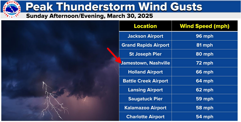
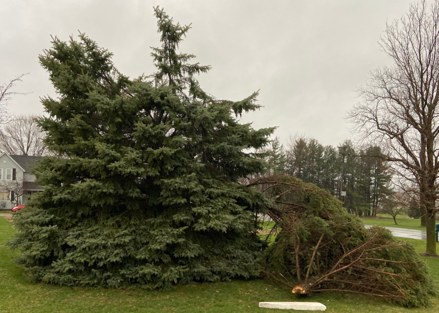
It got a little windy here today. I think outside of hurricane Ike when I lived in Central Ohio this is the highest wind I have ever recorded.
-
2
-
-
1 hour ago, A-L-E-K said:
extended looks active and wet, v nice
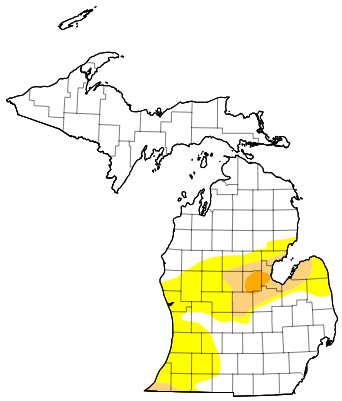
Given this week's drought monitor update it would sure be nice to see some active and wet weather. A lot of the region needs precip regardless of what form it takes.
-
2
-
-
30 minutes ago, RogueWaves said:
Have had nearly 150% of avg snow for Feb. But, like D & J, lets see how much we can melt away in the final few days of the month. (SMDH)
Same thing here. December and January started out with snow and melted it all off in the final few days. February is starting to feel like the movie Groundhog Day.
-
1
-
-
Had a mix resembling white rain but leaning towards snow here. Didn't accumulate though.
-
1 hour ago, TheClimateChanger said:
I'm just going off of xMacis. Looks like it's pretty typical for Ohio in a historical sense. Obviously, you may have done somewhat better in rural Knox county.
xMacis reports CMH has had 23 days with 1" or more, which is only 36th most since 1948, and even that exaggerates the rarity versus limiting the comparison to the 1950 to early/mid 90s time frame.

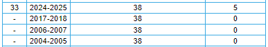
CLE has had 38 days of 1" or more snow cover. Looks like 69 other years have had as many or more [out of 133 years], and that includes a bunch of years from downtown where the snow cover would be less resilient.
CAK has also had 38 days of 1" or more snow cover, which is a bit more impressive. But even still 35 other years had at least that many [out of 76 years with sufficient data], so pretty much par for the course [at least historically].
What about consecutive days, vs the snow then melt then snow dilly84 referenced?
Late June 2025 Heat Wave
in Lakes/Ohio Valley
Posted
At least now we know who to blame for this....