

snowman19
-
Posts
7,493 -
Joined
Content Type
Profiles
Blogs
Forums
American Weather
Media Demo
Store
Gallery
Posts posted by snowman19
-
-
3 minutes ago, White Gorilla said:
I am curious how the ridge axis out west would sharpen better given the strong Pacific flow
@bluewave Pointed this out yesterday, you have a raging fast, record PAC jet circling almost the entire globe, blasting right into the west coast. Any +PNA that tries to form can’t sustain itself, that strong jet just crashes right into it and knocks it down as fast as it pops up
-
 2
2
-
-
Just now, Allsnow said:
Looks to be all southern stream. I would think temps are warm for the coast.
All southern stream and a low in the Great Lakes
-
 1
1
-
2
-
-
4 minutes ago, SnowGoose69 said:
With no -NAO the southern stream alone wouldn’t get this up here anyway. The ICON scenario isn’t really logical. In order to get a solely southern stream system like 2/83 or 12/09 the NAO has to be fairly negative
This! The setup is really horrible. No -NAO, no -AO, no 50/50 low, +EPO, +WPO, a positively tilted trough, and a marginal, weak +PNA that isn’t really poleward. When you combine this with the fact that there is a very putrid Pacific airmass over us with no arctic high locked in over SE Canada to funnel the cold down, good luck getting a snowstorm in the metro area this weekend
-
4
-
-
1 minute ago, Allsnow said:
We had a completely different h5 set up for Boxing Day lol. Just because it trended west does not automatically make it comparable.
The issue is the progressive nature of the flow { wave spacing and vortex} all killing the sharpness of the ridge.
Lmaooo exactly. There is absolutely no comparison whatsoever to Boxing Day, zero lol. You had an extreme -NAO and -AO and deep arctic air with a banana high in place, strong 50/50 low, among other things, nothing is similar to this weekend
-
3
-
 1
1
-
1
-
-
Pretty bad info given, the GFS wasn’t a “solid hit” unless 1-2 inches total is considered a solid hit now: https://www.tropicaltidbits.com/analysis/models/?model=gfs®ion=neus&pkg=asnowd&runtime=2020012618&fh=198
-
1
-
 1
1
-
2
-
-
1 hour ago, Rtd208 said:
In addition to my post above. Larry Cosgrove seem to think the pattern/models is pointing to another milder month here in February and also doesn't think any kid blocking will be present at least thru most of March. On a positive note, he still believes we will turn colder and have a backloaded winter (his opinion), we'll see.
Just read Larry’s newsletter from yesterday evening, he seems unenthusiastic about next weekend’s system as far as snow on the east coast and he wrote off February as mild for the eastern seaboard with little if any high latitude blocking. He seems to think the end of February through mid-March gets cold, then he’s thinking a very rapid warmup takes hold right after mid-March with a La Niña possibly developing
-
1
-
1
-
1
-
-
12 minutes ago, Snow88 said:
With a low that strong? LoL
Look back at the coastal storms of Jan, Feb, and Mar, 1998. Very strong lows took benchmark and east of benchmark tracks and they were all rain for the entire metro area
-
2
-
1
-
-
11 minutes ago, Mersky said:
He is a daily limited poster just like his buddy snowman19 for a reason.
You should be 5 posted. You contribute nothing because you know nothing I’m sure and are nothing but a troll
-
2
-
1
-
-
2 minutes ago, NutleyBlizzard said:
Believe me It wont be. Taken verbatim that's snow down to the coast. Typical warm thermal bias with the global models. Good thing at this point is we have a signal for a strong storm. Bad thing is my Superbowl party could be in serious jeopardy.
Why exactly wouldn’t it be rain? The cold is not there near the coast
-
1
-
3
-
-
4 minutes ago, Allsnow said:
I like HM but he has busted very badly so far. He called for a very cold and snowy December and January with massive -EPO and +PNA blocking, he also called for a continuation of cold/snow through February. It hasn’t been a good winter for him at all
-
1
-
-
5 minutes ago, Snow88 said:
Hopefully the icon has a clue.
The ICON Lmfaoo!!
-
1
-
-
13 minutes ago, donsutherland1 said:
Morning thoughts...
At 9 am, rain was moving into the New York City Metro Area. As of 9 am, rainfall totals included: Baltimore: 1.47"; Philadelphia: 0.59"; and, Washington, DC: 1.33". A widespread 0.50"-1.50" rainfall with some locally higher amounts remains on track for the region.
Meanwhile, ENSO and teleconnections developments have continued to evolve toward a scenario where a milder February may now be more likely than a colder one.
During February, the ENSO Region 3.4 anomaly will likely average 0.00°C to +0.75°C. The most recent 6-week moving average is +0.52°C.
During February, both the AO and EPO will likely remain predominantly positive. The AO has been positive on 75% days this winter to date, including 68% during which it was +1.000 or above.
This ENSO-teleconnections combination typically favors a warmer than normal February.
Late yesterday (18z GEFS) and overnight (0z EPS/0z and 6z GEFS) now show the trough shifting to the west and potential ridge development in the East near the end of their timeframes.
In addition, the CFSv2 has been steadily evolving toward a milder solution in the East.
Most recent CFSv2 forecasts:
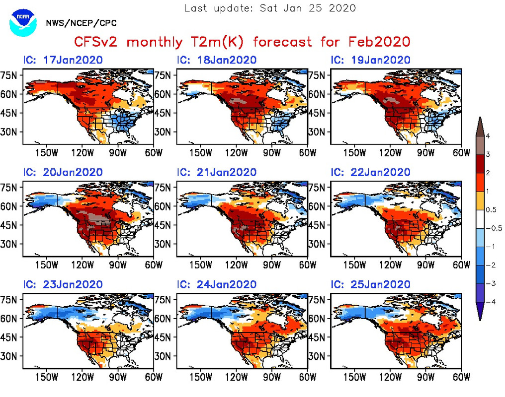
The CFS has been getting warmer and warmer for February with each run. Now that we are at the tail end of January, the CFS holds more weight. Based on the latest ensembles, the ugly pattern continues at least through the 1st 2 weeks of February.....
-
1
-
1
-
-
10 minutes ago, jm1220 said:
If there isn’t a good PNA ridge and/or some blocking, this will likely end up over Detroit. I’m more interested in those over any particular storm.
The EPS was definitely huggy
-
1
-
2
-
-
16 minutes ago, PaulyFromPlattsburgh said:
yikes 12z gfs cuts that day 9 threat now.
No 50/50 low, No -NAO block, it can easily amp and cut, nothing to stop it
-
1
-
1
-
2
-
-
23 minutes ago, Snow88 said:
Gfs


Best of luck getting snow anywhere south of New England next weekend. There is no cold air, you kinda need that to snow....
-
 1
1
-
1
-
-
31 minutes ago, Barman49 said:
What is the date of the last Miller A to hit the east coast?? We were so spoiled it seems like 5 years ago.
Sent from my GM1925 using Tapatalk
We’ve really been spoiled for the last 20 years. 2000-2019 when all added up and averaged out had way more anomalous cold and snowy winters than the previous 20 year cycle (1979-1999), which by and large were duds minus a few. It seems to go in 20 year cycles for the most part; the 1959-1979 winters were way more anomalous for cold and snow than the winters which followed.....
-
1 hour ago, Allsnow said:
Gefs in agreement with eps/geps at 12z with flushing out the vortex first week of February. Let’s see if we can hold this as we move closer.
Until it’s under 10 days, and even then, I view these new model runs with extreme skepticism. The models have been making the pattern look great, very cold and snowy, blocking in the long range for several runs in a row, keep it there, never move it forward in time, then they lose it completely. This has been going on literally since the first week of December. It honestly reminds of 2011-2012 when the models showed a great pattern in the long range that never materialized from December right through March. AK vortexes normally are not in a hurry to just disappear without a fight. I’ll believe it when I see it. I still don’t think we see a true full scale change, if there is to be one, until the end of February....
-
4
-
-
1 hour ago, forkyfork said:
maybe this one will happen!
Extremely marginal PAC airmass in place and that’s putting it nicely, no arctic high in SE Canada, +EPO, no strong 50/50 low, no -NAO block to stop it from becoming an inland runner/lakes cutter should it amp up....what could possibly go wrong??
-
2
-
-
4 hours ago, RDRY said:
Ah, the EURO with the next tracking debacle to appropriately close this fine month. Two days to meltdown? Four?
The ridge out west is meaningless. It’s still a crud, garbage pac maritime airmass trapped over us. Same pattern next weekend. The Euro has been doing this ALL winter, it’s been absolutely horrible
-
34 minutes ago, Allsnow said:
Yes, but it originates from the pac as the vortex is wound tight with all the cold. Nice pna spike but a crap airmass. The eps has less then a inch for that timeframe
This! It’s what some people don’t understand, all the +PNA is doing is trapping PAC air, even if a -NAO block were to form, it would just trap the crap PAC air coming in from the west at that time under the block. It’s a putrid maritime airmass
-
1
-
1
-
-
3 minutes ago, bluewave said:
Yeah, we may end up needing help from MJO or other factors to get that vortex out of Alaska. This is our first time since the 2006-2012 era that we had such a strong +EPO from December into at last the start of February. The chart below shows how different this is from what we have experienced since 2012. The CPC chart is the inverse of how we typically discuss the EPO. The negative values are what we consider the +EPO. The positive values since 2013 reflect the predominant -EPO over this period.
https://www.cpc.ncep.noaa.gov/data/teledoc/ep_ts.shtml

Agreed. I just don’t think that vortex simply goes away overnight. It’s almost always a process. If a real change is to actually come, I think it’s the end of February or even the beginning of March
-
42 minutes ago, sferic said:
Are the catkills at 1500 feet on up still game for snow on Saturday?
If the models are correct, it even turns to rain in the Catskills Saturday
-
1
-
-
54 minutes ago, Allsnow said:
The roundy plots have the kelvin weakening and moving closer to the colder phases. Then around feb 10-15 we are in p1/2.
I think if there is to be a change it’s post 2/15, more like late/end of February. Vortex over AK setups just don’t flip overnight, they always stay longer than expected, then you have to seed Canada with cold again and scour out the PAC maritime air....that’s takes some time. Come March, with the wavelength change, IO forcing is actually cold, not warm anymore, so if we have IO forcing at that point, I’d expect a cold March, yet again
-
2
-
-
25 minutes ago, Snow88 said:
Eps is really interesting. There are several members witn accumulating snow right to the coast.
The EPS actually went north with the upper level low since the last run, a bad sign even for southern New England
-
1
-
1
-


Mid to Long Range Threats
in New York City Metro
Posted
The Euro is even further OTS than the CMC, like next to no precip at all this weekend