

Stovepipe
-
Posts
4,255 -
Joined
-
Last visited
Content Type
Profiles
Blogs
Forums
American Weather
Media Demo
Store
Gallery
Posts posted by Stovepipe
-
-
4 minutes ago, Jed33 said:
MRX evening update. Pay special attention to the last part! WPC has upped totals and thinks it will be easy to exceed 8in Central Valley and north! Astounding to say the least!

000
FXUS64 KMRX 150308 AAB
AFDMRX

Area Forecast Discussion...UPDATED
National Weather Service Morristown TN
1008 PM EST Sun Jan 14 2024

...New UPDATE...

.UPDATE...
Issued at 944 PM EST Sun Jan 14 2024

A bit late on the evening update here, but wanted to have a little bit to see some early time steps of the 00z guidance and see the radar trends this evening as snow began to make it into our CWA.

Main changes to the forecast were to update the PoP grids to
reflect current radar trends and pretty strong onset of snowfall
pushing into our area over the next 4-6 hours. Have seen several reports from Knoxville and points west that show snowfall accumulating on surfaces already. Albeit light, the fact that it`s already accumulating certainly lends confidence to the increase in
snowfall totals with the afternoon forecast package earlier today.
Current NBM hourly PoPs show this initial wave of precip moving out around 09z, with a distinct lull thereafter through about 13-14z before the main show moves in after daybreak. This seems very reasonable given the latest CAM guidance, but do not want to try and time a 3-4hr lull in precipitation given that it won`t have a significant impact on expected storm total amounts.

Another notable change was to include some sleet and freezing rain precip types down in the Marion county area. NAM forecast
soundings for Huntsville this evening did indeed show a weak warm
nose through much of the overnight hours. Conceptually this would
extend further ENE into our CWA in the warm SWLY flow around
850mb in that region. We`ve had a report of a light glazing in
parts of eastern Marion county which confirms this thinking. Not
expecting this to last as the column will continue to cool and
precip rates increase. But it is in line with the uncertainty in
ptypes, and storm total accumulations for the southern valley and
far southeast Tennessee.

Lastly, WPC has upped the snowfall amounts for the event in the I-40 corridor and points north. Didn`t want to make wholesale changes to the forecast for the evening update, but this trend doesn`t seem unreasonable given what`s already occurring this
evening. And it is worth noting that for the last few days, NBM
and HREF probabilistic guidance has been showing some healthy
probability of seeing storm total snowfall amounts easily
exceeding 8" across portions of the forecast area. Will let the
overnight shift make any substantive changes that are necessary since they will have the full suite of the latest NBM
probabilistic guidance as well as the 00z models at their

-
 6
6
-
 7
7
-
-
It escalated in Halls, moderate snow, wind whipping. Got a dusting quick and building.
-
9
-
-
Just now, Jesse from KY said:
I am happy to say that it just started snowing at my location in Bell County. Temp is 27F
I'm happy for you, make the most of it, I expect snow angel pics by morning!
-
4
-
 1
1
-
-
1 minute ago, Silas Lang said:
Yeah, this storm could prove to be truly historic. A long duration, state wide mauler of a snow storm. Factor in the artic air and the fact that things will be shut down a few days...this one will be remembered.
Yep, seems like an historic 20 year storm for sure.
Edit: Watch me end up with 2 inches lol.
-
4
-
1
-
-
7 minutes ago, PowellVolz said:
Surprised at what’s falling vs what’s on radar. This is moderate snow with 50% fatties mixed in.

.Squeezing out some pretty good flakes at 29.5 degrees and low returns, I'll allow it!
-
3
-
-
3 minutes ago, nrgjeff said:
Last visit and post for the night. @Chattownsnow and @Uncle Nasty I think the chart above from @TellicoWx eases the Chattanooga anxiety a little bit. We should be able to avoid a Dallas Cowboys style melt-down.
I'll feel better when I see snow falling. Warm air is hanging tough in KCHA but we're always the last to cool off. Already snowing in Knoxville. LOL Chatty. Back to the game!
-
5
-
1
-
3
-
 1
1
-
-
Just now, Greyhound said:
Coming down pretty good in Fountain City
.
-
3
-
1
-
2
-
1
-
-
7 minutes ago, BhamParker said:
Light snow and already a dusting on the grassy and elevated surfaces for now. I am 3,000 feet off Ski Mointain Road in Gatlinburg.
.I'm so glad that is working out for you, y'all enjoy it!
-
3
-
-
1 minute ago, Keith said:
I am also in Halls (KTNKNOXV674) and stuck on 33.
Nice to meet you Keith, you are a stone's throw from my house! Don't worry, I'll only throw snowballs.

-
3
-
3
-
-
Getting our first flakes in Halls!
-
13
-
-
1 minute ago, Greyhound said:
Stove……What’s the name/station ID of yours (if you don’t mind me asking)
.KTNKNOXV744, there's a link in my sig. Just hit the freezing mark!
-
4
-
-
2 minutes ago, bearman said:
Tiny dust speck flakes in North Knox. Mybe real dust flakes!
Possibly brine flakes!
-
2
-
4
-
-
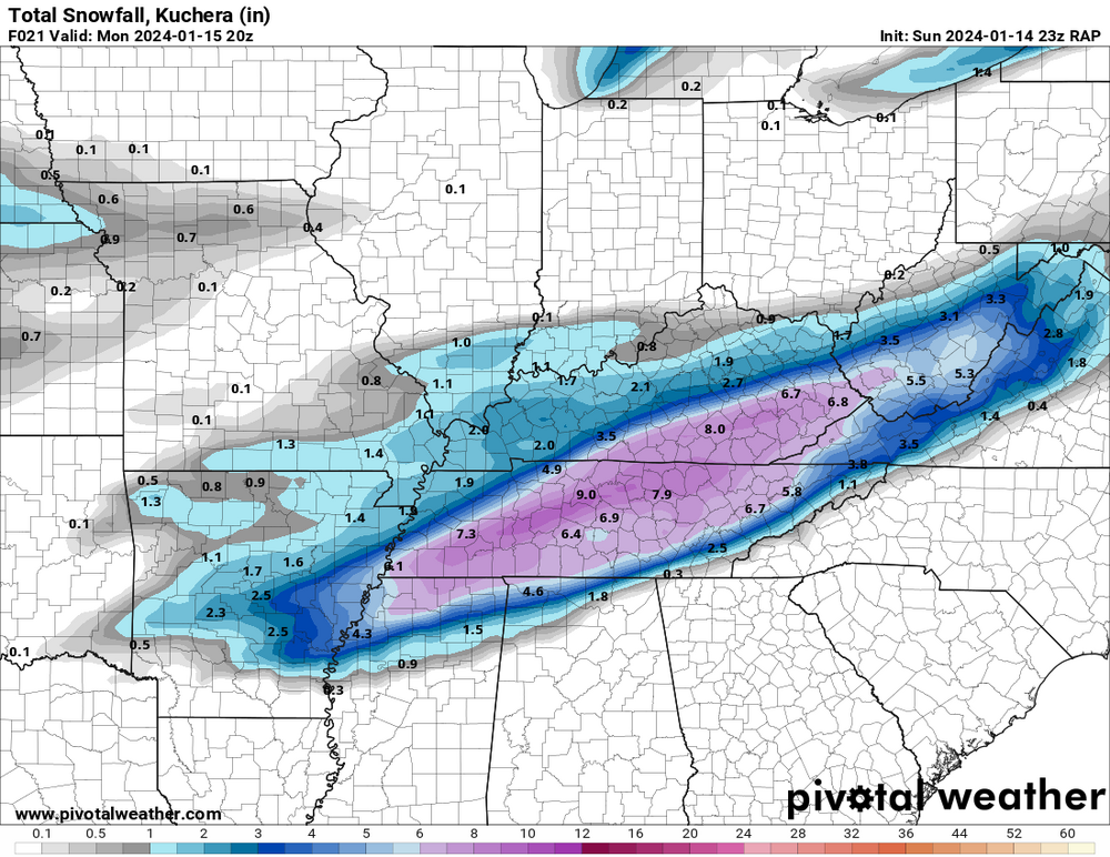
1 minute ago, Kentucky said:
23z RAP thru 21

-
4
-
1
-
-
15 minutes ago, PowellVolz said:

.At least we know our weather stations are calibrated, I'm right there with you.
Also, LOL at the ads!
-
1
-
1
-
-
Apologies to Mr. Boyd and Mr. Thompson.

-
3
-
1
-
9
-
-
1 minute ago, Mrwolf1972 said:
My dew point down to 21 south loudon temp 36
Sent from my SM-S916U1 using Tapatalk
Same in Halls.
-
2
-
-
1 minute ago, Tucker1027 said:


.I like this guy, he looks like the Hunter S. Thompson of the weather world.
-
2
-
-
21 minutes ago, PowellVolz said:

.I may have to order me a pair of those sweet pink loafers!
-
3
-
2
-
-
2 minutes ago, BlunderStorm said:
RAP significantly upped totals for 21z across the board.

Great googly moogly!

-
2
-
5
-
-
2 minutes ago, Carvers Gap said:
Yeah, it does. Chattanooga is in the mix as well.
Phrasing!
-
1
-
2
-
-
22 minutes ago, Olhausen said:
You think the globals are going to be way off with this one? Short range models have been showing way higher totals to the north pretty much every run since this system got within their range.
Prepare the pancake table my friend and post pics!
-
1
-
1
-
-
35 minutes ago, PowellVolz said:
I was counting on 14:1 north of 40 in ETn. Is that too steep?
.I was thinking of you when driving down a freshly brined Maynardville Hwy yesterday.
-
1
-
-
12z GFS with a 12 inch dollop on Reb.

-
4
-
2
-
-
Just now, fountainguy97 said:
Rufus!!
Took the words right out of my mouth, I was just about to post Rufus!
-
3
-
2
-

January 15th-17th 2024 Arctic Blast/Snow Event
in Tennessee Valley
Posted
Models are trolling at this point.