

Metasequoia
-
Posts
660 -
Joined
-
Last visited
Content Type
Profiles
Blogs
Forums
American Weather
Media Demo
Store
Gallery
Posts posted by Metasequoia
-
-
4 minutes ago, wilsonvoid1 said:
honestly the euro 18z looks good 8-10 inches of slop for NYC!

Borrowed this from New England thread @rgwp96 thank you.
A lot could change if it cranks sunday! we could get an easy 6 inches just from Sunday afternoon if dynamic cooling takes shape!
.Thanks. Unrealistic 10 to 1 ratios, but still nice to have something to track.
-
Has the NAM received an upgrade since last Winter? If not, I think we have plenty of reason to be skeptical about its outputs.
-
10 minutes ago, pazzo83 said:
Yeah - that was the case with Hugo when it passed over Charlotte. The damage was extensive.
Fran in 1996 was a bruiser for Raleigh Durham. Widespread power outages and blocked roads for over a week.
-
FWIW - the 18Z 3K NAM looks much better than the 12K and not much different than 12Z.
-
The model run to run consistency is pretty bad. I agree with Rjay that we still don't have a good handle on this storm. The setup looks sensitive to modest changes. I could see the Euro swinging heavy snow back into the City on the next run.
-
 1
1
-
-
Would a met or someone that knows their stuff provide some guidance on using ensembles near the start of a storm? How useful are they at this point?
-
1 minute ago, jm1220 said:
If we can get the Euro to show that as well for a couple runs, maybe we're onto something. Trend does seem to be to develop that offshore low sooner which brings colder air in and heavy snow banding.
The three best models showing significant impacts tonight would be quite welcome. Let's see. Euro has has decent runs as of late...
-
1
-
-
2 minutes ago, mannynyc said:
UKMET bomb

Now this is finally getting interesting for NYC.
-
1
-
-
Nam not so different from the GFS...in tuck and snowfall outputs. So maybe it's the Americans vs. the world. Euro can be the tie breaker.
-
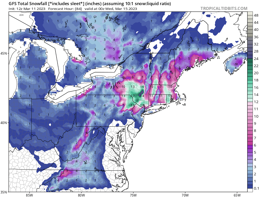
33 minutes ago, romba said:
Vastly different snow maps- Tidbits 10:1 GFS snow map
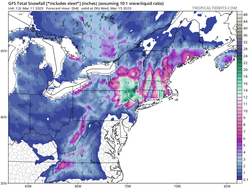
versus Pivotal 10:1
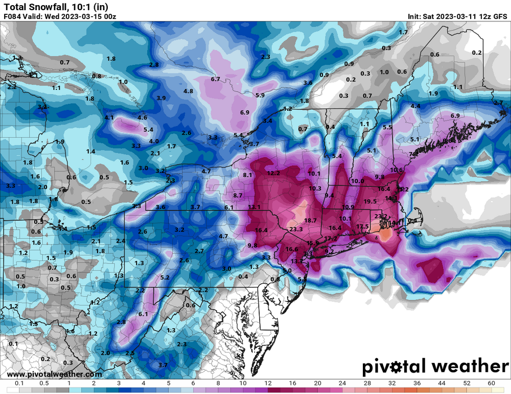
Tropical Tidbits has issues with depicting snow accumulations for Long Island and parts of the City. I think this partly explains the difference between the two maps.
-
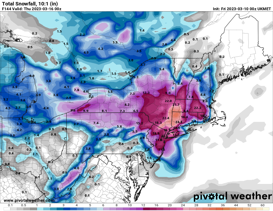
1 minute ago, David-LI said:
Coppied from NE forum
Where can I sign?
Looks great...perhaps the boundary layer doesn't support these accumulations?
-
I thought the GFS and CMC were close to something decent for NYC. If the low bombs out 6 or so hours earlier then maybe the CCB clobbers.
-
1
-
-
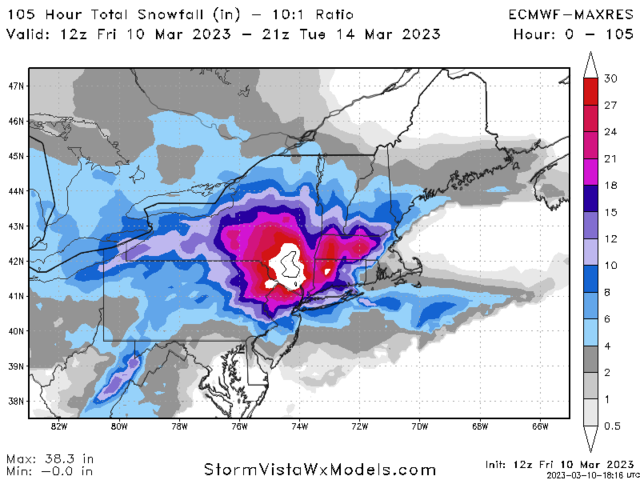
6 minutes ago, Rjay said:
Weenie map

Ukie has produced a few runs like this recently...maybe not quite this good though.
-
Looks closer a BECS than a MECS.
-
2 minutes ago, brooklynwx99 said:
UKMET closes S of LI. MECS verbatim
.png.d1f3fc01fd4bff2dbed9a64672d30492.png)
Ideal track for the metro?
-
6 minutes ago, jm1220 said:
Horrendous. 3/14/17 all over again but even warmer this time so maybe we get a snow shower at the end while I-84 gets two feet. Worst winter ever.
Five days to go. The low could still end up being 50 plus miles east and stronger, which would significantly change the outcome for the better. Of course it could just rain too...
-
 1
1
-
-
13 minutes ago, Heisy said:
Is that basically the control run?
.I thought para was a new version of a weather model that's being tested.
-
33 minutes ago, MJO812 said:
Euro para !


Hmmm...I wonder how it compares to the standard European model regarding accuracy.
-
12 minutes ago, NutleyBlizzard said:
We need it to to go benchmark and really bomb out. There’s no cold high in place.
Yes. Nearly everything has to go right for the City...lower Hudson Valley has more hope. Maybe there's a slushy inch for wave one unless a norlun appears from the mists.
-
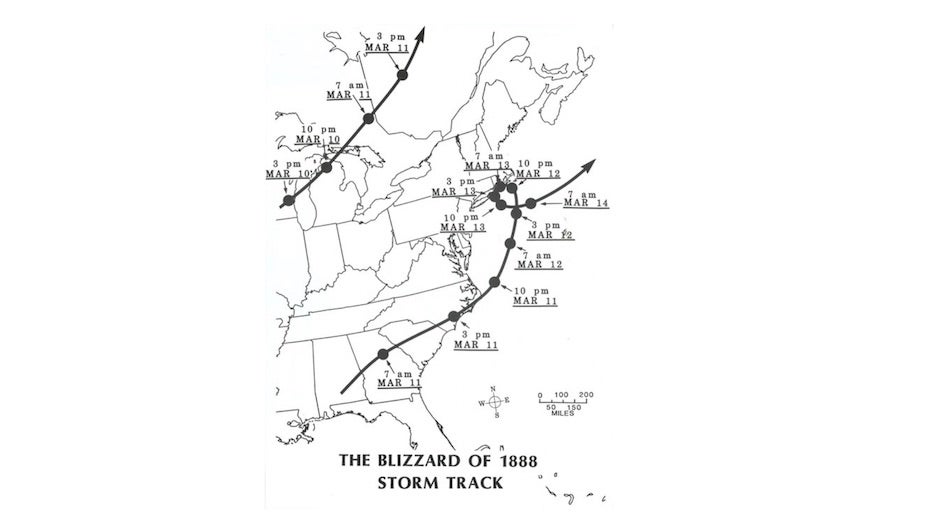
2 minutes ago, SnoSki14 said:
How did March 1888 play out? Was that a miller B
-
1
-
-
I don't hate this look a week out ...obviously further south is preferred.
-
2
-
-
It's time to move onto the next late season opportunity whatever that is. There hasn't been a good model run for our region in days and the storm is two days away.
-
A fourth flash and crack of thunder in BPC...and still not really sticking. Pretty sweet nonetheless.
-
1 minute ago, Metasequoia said:
Second lightening strike with thunder in Battery Park City. So weird.
A third time just now.
-
1
-

Snow Friday 1/19/24: is it a period of light snow (less than 2"), or is there a chance of a 5" swath in part of the NYC subforum? Event OBS.
in New York City Metro
Posted
Also, the "big winners" might only get a couple more inches of snow.
Looks like it will snow tomorrow and cover more than just cold surfaces and even stick around for a few days. I'd call that a win this season.
Also, inverted troughs are biatches to forecast.